 |
|
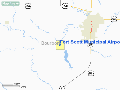
Fort Scott Municipal Airport |
Coordinates: 37°47â²54â³N 094°46â²10â³W / 37.79833°N 94.76944°W / 37.79833; -94.76944
| Fort Scott Municipal Airport |
| IATA: FSK â ICAO: KFSK â FAA LID: FSK |
| Summary |
| Airport type |
Public |
| Owner |
City of Fort Scott |
| Serves |
Fort Scott, Kansas |
| Elevation AMSL |
918 ft / 280 m |
| Runways |
| Direction |
Length |
Surface |
| ft |
m |
| 18/36 |
4,403 |
1,342 |
Asphalt |
| Statistics (2006) |
| Aircraft operations |
10,980 |
| Based aircraft |
18 |
| Source: Federal Aviation Administration |
Fort Scott Municipal Airport (IATA: FSK, ICAO: KFSK, FAA LID: FSK) is a city-owned public-use airport located four miles (6 km) southwest of the central business district of Fort Scott, a city in Bourbon County, Kansas, United States.
Facilities and aircraft
Fort Scott Municipal Airport covers an area of 245 acres (99 ha) which contains one asphalt paved runway (18/36) measuring 4,403 x 75 ft (1,342 x 23 m). For the 12-month period ending May 10, 2006, the airport had 10,980 aircraft operations, an average of 30 per day: 96% general aviation, 2% air taxi and 2% military. At that time there were 18 aircraft based at this airport: 67% single-engine and 33% multi-engine.
The above content comes from Wikipedia and is published under free licenses – click here to read more.
|
Location &
QuickFacts
|
FAA
Information Effective: |
2008-06-05 |
|
Airport
Identifier: |
FSK |
|
Airport
Status: |
Operational |
|
Longitude/Latitude: |
094-46-09.7000W/37-47-54.1000N
-94.769361/37.798361 (Estimated) |
|
Elevation: |
918 ft / 279.81 m (Surveyed) |
|
Land: |
245 acres |
|
From
nearest city: |
4 nautical miles SW of Fort Scott, KS |
|
Location: |
Bourbon County, KS |
|
Magnetic Variation: |
04E (1995) |
Owner & Manager
|
Ownership: |
Publicly owned |
|
Owner: |
City Of Fort Scott |
|
Address: |
1 East 3rd Street
Fort Scott, KS 66701 |
|
Phone
number: |
620-223-0550 |
|
Manager: |
Kenny Howard |
|
Address: |
1869 Indian Rd., P.o. Box 151
Fort Scott, KS 66701 |
|
Phone number: |
620-223-5490 |
Airport Operations and Facilities
|
Airport
Use: |
Open to public |
|
Wind
indicator: |
Yes |
|
Segmented Circle: |
No |
|
Control
Tower: |
No |
|
Lighting
Schedule: |
DUSK-DAWN
ACTVT MIRL RY 18/36; VASI RY 18; PAPI RY 36 & REIL RYS 18 & 36 - CTAF. |
|
Beacon
Color: |
Clear-Green (lighted land airport) |
|
Landing
fee charge: |
No |
|
Sectional chart: |
Kansas City |
|
Region: |
ACE - Central |
|
Traffic
Pattern Alt: |
800 ft |
|
Boundary
ARTCC: |
ZKC - Kansas City |
|
Tie-in
FSS: |
ICT - Wichita |
|
FSS on
Airport: |
No |
|
FSS Toll
Free: |
1-800-WX-BRIEF |
|
NOTAMs
Facility: |
ICT (NOTAM-d service avaliable) |
|
Federal Agreements: |
NGY |
Airport Communications
|
CTAF: |
122.800 |
|
Unicom: |
122.800 |
Airport Services
|
Fuel
available: |
100LLA1+ |
|
Airframe
Repair: |
NONE |
|
Power
Plant Repair: |
NONE |
|
Bottled
Oxygen: |
NONE |
|
Bulk
Oxygen: |
NONE |
|
Runway Information
Runway 18/36
|
Dimension: |
4403 x 75 ft / 1342.0 x 22.9 m |
|
Surface: |
ASPH, Good Condition |
|
Weight Limit: |
Single wheel: 12500 lbs. |
|
Edge Lights: |
Medium |
|
|
Runway 18
|
Runway 36
|
|
Longitude: |
094-46-09.7451W |
094-46-09.6794W |
|
Latitude: |
37-48-15.8511N |
37-47-32.3239N |
|
Elevation: |
903.00 ft |
918.00 ft |
|
Alignment: |
127 |
127 |
|
Traffic
Pattern: |
Left |
Left |
|
Markings: |
Non-precision instrument, Good Condition |
Non-precision instrument, Good Condition |
|
Crossing
Height: |
39.00 ft |
39.00 ft |
|
VASI: |
4-box on left side |
2-light PAPI on left side |
|
Visual
Glide Angle: |
3.00° |
3.00° |
|
Runway End
Identifier: |
Yes |
Yes |
|
Centerline
Lights: |
No |
No |
|
Touchdown
Lights: |
No |
No |
|
Obstruction: |
18 ft tree, 342.0 ft from runway, 59 ft right of
centerline, 8:1 slope to clear |
49 ft road, 936.0 ft from runway, 15:1 slope to clear |
|
Radio Navigation Aids
|
ID |
Type |
Name |
Ch |
Freq |
Var |
Dist |
|
FSK |
NDB |
Fort Scott |
|
379.00 |
05E |
0.2 nm |
|
PTS |
NDB |
Pittsburg |
|
365.00 |
05E |
21.5 nm |
|
EAD |
NDB |
Nevada |
|
209.00 |
06E |
22.5 nm |
|
LLU |
NDB |
Spring River |
|
356.00 |
05E |
28.8 nm |
|
MSB |
NDB |
Monarch |
|
410.00 |
04E |
30.7 nm |
|
PPF |
NDB |
Parsons |
|
258.00 |
06E |
44.8 nm |
|
CNU |
VOR/DME |
Chanute |
029X |
109.20 |
05E |
40.5 nm |
|
BUM |
VORTAC |
Butler |
106X |
115.90 |
07E |
31.4 nm |
|
OSW |
VORTAC |
Oswego |
123X |
117.60 |
08E |
43.7 nm |
Remarks
-
DEER FENCE AROUND
AIRPORT PERIMETER.
-
GROUND DROPS
RAPIDLY 250' FROM RWY END.
-
CONDL-PRVD THE
APCH TO RWY 17 IS MAINTAINED FOR A MINIMUM 34:1 GLIDE SLOPE AND RWY 36 FOR A
MINIMUM 20:1 GLIDE SLOPE AND THE TRANSITIONAL SURFACE BE MAINTAINED FOR A 7:1
SLOPE.
Based Aircraft
|
Aircraft based
on field: |
18 |
|
Single Engine
Airplanes: |
12 |
|
Multi Engine
Airplanes: |
6 |
Operational Statistics
Time Period: 2005-05-11 - 2006-05-10
|
Aircraft
Operations: |
212/Week |
|
Air Taxi: |
1.8% |
|
General
Aviation Local: |
64.5% |
|
General
Aviation Itinerant: |
31.9% |
|
Military: |
1.8% |
Fort Scott Municipal Airport
Address:
Bourbon County, KS
Tel:
620-223-0550,
620-223-5490
Images
and information placed above are from
http://www.airport-data.com/airport/FSK/
We
thank them for the data!
|
General Info |
| Country |
United
States |
| State |
KANSAS
|
| FAA ID |
FSK
|
| Latitude |
37-47-54.350N |
|
Longitude |
094-46-09.772W |
|
Elevation |
918 feet
|
| Near
City |
FORT
SCOTT |
We don't guarantee the information is fresh and accurate. The data may
be wrong or outdated.
For more up-to-date information please refer to other sources.
|
|


