 |
|
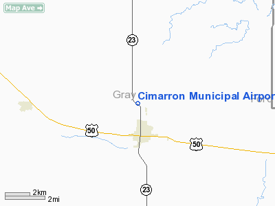
Cimarron Municipal Airport |
Coordinates: 37°49â²50â³N 100°21â²01â³W / 37.83056°N 100.35028°W / 37.83056; -100.35028
| Cimarron Municipal Airport |
| IATA: none â ICAO: none â FAA LID: 8K8 |
| Summary |
| Airport type |
Public |
| Owner |
City of Cimarron |
| Serves |
Cimarron, Kansas |
| Elevation AMSL |
2,752 ft / 839 m |
| Runways |
| Direction |
Length |
Surface |
| ft |
m |
| 01/19 |
2,800 |
853 |
Asphalt |
| 11/29 |
2,450 |
747 |
Turf |
| Statistics (2006) |
| Aircraft operations |
3,500 |
| Based aircraft |
10 |
| Source: Federal Aviation Administration |
Cimarron Municipal Airport (FAA LID: 8K8) is a city-owned public-use airport located two miles (3 km) north of the central business district of Cimarron, a city in Gray County, Kansas, United States.
Facilities and aircraft
Cimarron Municipal Airport covers an area of 80 acres (32 ha) which contains two runways: 01/19 with a 2,800 x 32 ft (853 x 10 m) asphalt pavement and 11/29 with a 2,450 x 50 ft (747 x 15 m) turf surface.
For the 12-month period ending June 13, 2006, the airport had 3,500 general aviation aircraft operations, an average of 10 per day. At that time there were 10 aircraft based at this airport: 100% single-engine.
The above content comes from Wikipedia and is published under free licenses – click here to read more.
|
Location &
QuickFacts
|
FAA
Information Effective: |
2008-06-05 |
|
Airport
Identifier: |
8K8 |
|
Airport
Status: |
Operational |
|
Longitude/Latitude: |
100-21-01.5200W/37-49-50.0760N
-100.350422/37.830577 (Estimated) |
|
Elevation: |
2752 ft / 838.81 m (Estimated) |
|
Land: |
80 acres |
|
From
nearest city: |
2 nautical miles N of Cimarron, KS |
|
Location: |
Gray County, KS |
|
Magnetic Variation: |
09E (1985) |
Owner & Manager
|
Ownership: |
Publicly owned |
|
Owner: |
City Of Cimarron |
|
Address: |
Po Box 467
Cimarron, KS 67835 |
|
Phone number: |
620-855-2215 |
|
Manager: |
Don Ratzlaff |
|
Address: |
Po Box 467
Cimarron, KS 67835 |
|
Phone number: |
620-855-2215 |
Airport
Operations and Facilities
|
Airport
Use: |
Open to public |
|
Wind
indicator: |
Yes |
|
Segmented Circle: |
No |
|
Control
Tower: |
No |
|
Lighting
Schedule: |
DUSK-DAWN
ACTVT LIRL RY 01/19 - CTAF. |
|
Beacon
Color: |
Clear-Green (lighted land airport) |
|
Landing
fee charge: |
No |
|
Sectional chart: |
Wichita |
|
Region: |
ACE - Central |
|
Boundary
ARTCC: |
ZKC - Kansas City |
|
Tie-in
FSS: |
ICT - Wichita |
|
FSS on
Airport: |
No |
|
FSS Toll
Free: |
1-800-WX-BRIEF |
|
NOTAMs
Facility: |
ICT (NOTAM-d service avaliable) |
|
Federal Agreements: |
N1 |
Airport Communications
Airport Services
|
Airframe
Repair: |
NONE |
|
Power
Plant Repair: |
NONE |
|
Bottled
Oxygen: |
NONE |
|
Bulk
Oxygen: |
NONE |
|
Runway Information
Runway 01/19
|
Dimension: |
2800 x 32 ft / 853.4 x 9.8 m |
|
Surface: |
ASPH, Good Condition
TURF ROUGH & UNEVEN WITH LOW SPOTS. |
|
Edge Lights: |
Low |
|
|
Runway 01
|
Runway 19
|
|
Longitude: |
100-20-51.0000W |
100-20-49.5200W |
|
Latitude: |
37-49-39.1800N |
37-50-06.8400N |
|
Traffic
Pattern: |
Left |
Left |
|
Markings: |
Nonstandard, Good Condition
01/19 NSTD MARKINGS; NO NRS AT THLDS & RY CNTRLN STRIPE IS NSTD DUE TO
SPACING; DSPLCD THLD MKD WITH NSTD LONGITUDINAL STRIPES. |
Nonstandard, Good Condition
RWY 01/19 NSTD MARKINGS; NO NRS AT THLDS & RY CNTRLN STRIPE IS NSTD DUE
TO SPACING; DSPLCD THLD MKD WITH NSTD LOGITUDINAL STRIPES. |
|
Displaced
threshold: |
170.00 ft |
280.00 ft |
|
Obstruction: |
15 ft road, 200.0 ft from runway, 120 ft left of
centerline
APCH RATIO 24:1 AT DSPLCD THR.
+15 FT ROAD AT 45 FT; 8 FT SIGNS 50 FT L OF CNTRLN. |
, 50:1 slope to clear
APCH RATIO 50:1 AT DSPLCD THR. |
|
Runway 11/29
|
Dimension: |
2450 x 50 ft / 746.8 x 15.2 m |
|
Surface: |
TURF, Poor Condition
TURF ROUGH & UNEVEN WITH LOW SPOTS. |
|
|
Runway 11
|
Runway 29
|
|
Traffic
Pattern: |
Left |
Left |
|
Obstruction: |
25 ft pline, 20.0 ft from runway |
, 50:1 slope to clear |
|
Radio Navigation Aids
|
ID |
Type |
Name |
Ch |
Freq |
Var |
Dist |
|
GC |
NDB |
Pieve |
|
347.00 |
09E |
17.8 nm |
|
MEJ |
NDB |
Meade |
|
389.00 |
09E |
32.8 nm |
|
TQK |
NDB |
Scott City |
|
256.00 |
08E |
46.6 nm |
|
DDC |
VORTAC |
Dodge City |
019X |
108.20 |
08E |
16.4 nm |
|
GCK |
VORTAC |
Garden City |
080X |
113.30 |
11E |
18.6 nm |
Remarks
-
PRVDD APCHS TO
ARPT ARE MAINT FOR A MIN 20:1 GLIDE SLOPE AND TRSNL SFC MAINT FOR 7:1 SLOPE.
Based Aircraft
|
Aircraft based
on field: |
6 |
|
Single Engine
Airplanes: |
6 |
Operational Statistics
Time Period: 2005-06-14 - 2006-06-13
|
Aircraft
Operations: |
68/Week |
|
General
Aviation Local: |
85.7% |
|
General
Aviation Itinerant: |
14.3% |
Cimarron Municipal Airport
Address:
Gray County, KS
Tel:
620-855-2215
Images
and information placed above are from
http://www.airport-data.com/airport/8K8/
We
thank them for the data!
|
General Info |
| Country |
United
States |
| State |
KANSAS
|
| FAA ID |
8K8
|
| Latitude |
37-49-50.076N |
|
Longitude |
100-21-01.520W |
|
Elevation |
2752
feet |
| Near
City |
CIMARRON
|
We don't guarantee the information is fresh and accurate. The data may
be wrong or outdated.
For more up-to-date information please refer to other sources.
|
|


