 |
|
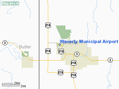
Waverly Municipal Airport |
|
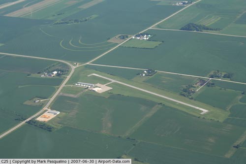 |
(Click on the photo to enlarge) |
Location &
QuickFacts
|
FAA
Information Effective: |
2007-07-05 |
|
Airport
Identifier: |
C25 |
|
Airport
Status: |
Operational |
|
Longitude/Latitude: |
092-30-28.5670W/42-44-31.0290N
-92.507935/42.741953 (Estimated) |
|
Elevation: |
992 ft / 302.36 m (Surveyed) |
|
Land: |
48 acres |
|
From
nearest city: |
2 nautical miles NW of Waverly, IA |
|
Location: |
Bremer County, IA |
|
Magnetic Variation: |
05E (1970) |
Owner & Manager
|
Ownership: |
Publicly owned |
|
Owner: |
City Of Waverly
MIKE CHERRY - PUBLIC WORKS DEPT. |
|
Address: |
110 1st Ave Se
Waverly, IA 50677 |
|
Phone
number: |
319-352-4252 |
|
Manager: |
Chris Renner |
|
Address: |
1710 35th St Nw
Waverly, IA 50677 |
|
Phone number: |
319-352-4703 |
Airport Operations and Facilities
|
Airport
Use: |
Open to public |
|
Wind
indicator: |
Yes |
|
Segmented Circle: |
No |
|
Control
Tower: |
No |
|
Lighting
Schedule: |
DUSK-DAWN
ACTVT LIRL RY 11/29 - CTAF. |
|
Beacon
Color: |
Clear-Green (lighted land airport) |
|
Landing
fee charge: |
No |
|
Sectional chart: |
Chicago |
|
Region: |
ACE - Central |
|
Boundary
ARTCC: |
ZAU - Chicago |
|
Tie-in
FSS: |
FOD - Fort Dodge |
|
FSS on
Airport: |
No |
|
FSS
Phone: |
515-955-8114 |
|
FSS Toll
Free: |
1-800-WX-BRIEF |
|
NOTAMs
Facility: |
FOD (NOTAM-d service avaliable) |
|
Federal Agreements: |
NY1 |
Airport Communications
|
CTAF: |
122.800 |
|
Unicom: |
122.800 |
Airport Services
|
Fuel
available: |
100LL |
|
Airframe
Repair: |
MAJOR |
|
Power
Plant Repair: |
MAJOR |
|
Bottled
Oxygen: |
NONE |
|
Bulk
Oxygen: |
NONE |
|
Runway Information
Runway 11/29
|
Dimension: |
2800 x 50 ft / 853.4 x 15.2 m |
|
Surface: |
ASPH, Good Condition |
|
Weight Limit: |
Single wheel: 12500 lbs.
Dual wheel: 16000 lbs. |
|
Edge Lights: |
Low |
|
|
Runway 11
|
Runway 29
|
|
Longitude: |
092-30-46.4620W |
092-30-10.6030W |
|
Latitude: |
42-44-35.1170N |
42-44-26.9670N |
|
Elevation: |
992.00 ft |
983.00 ft |
|
Alignment: |
107 |
127 |
|
Traffic
Pattern: |
Left |
Left |
|
Markings: |
Non-precision instrument, Fair Condition |
Non-precision instrument, Fair Condition |
|
Crossing
Height: |
30.00 ft |
30.00 ft |
|
VASI: |
2-light PAPI on left side |
2-light PAPI on left side |
|
Visual
Glide Angle: |
3.00° |
3.00° |
|
Runway End
Identifier: |
Yes |
Yes |
|
Obstruction: |
23 ft trees, 880.0 ft from runway, 115 ft right of
centerline, 29:1 slope to clear |
, 50:1 slope to clear |
|
Radio Navigation Aids
|
ID |
Type |
Name |
Ch |
Freq |
Var |
Dist |
|
CCY |
NDB |
Charles City |
|
375.00 |
03E |
20.1 nm |
|
OLZ |
NDB |
Oelwein |
|
260.00 |
02E |
23.7 nm |
|
IY |
NDB |
Chukk |
|
417.00 |
03E |
25.5 nm |
|
IIB |
NDB |
Wapsie |
|
206.00 |
02E |
30.2 nm |
|
HPT |
NDB |
Hampton |
|
230.00 |
03E |
31.7 nm |
|
XWY |
NDB |
West Union |
|
278.00 |
02E |
34.2 nm |
|
IFA |
NDB |
Iowa Falls |
|
368.00 |
03E |
37.1 nm |
|
VTI |
NDB |
Garrison |
|
338.00 |
03E |
38.0 nm |
|
CJJ |
NDB |
Cresco |
|
293.00 |
02E |
41.0 nm |
|
MIW |
NDB |
Marshalltown |
|
239.00 |
03E |
42.1 nm |
|
DEH |
NDB |
Decorah |
|
236.00 |
01E |
46.7 nm |
|
JWJ |
VOR/DME |
Elmwood |
031X |
109.40 |
03E |
41.9 nm |
|
ALO |
VORTAC |
Waterloo |
059X |
112.20 |
06E |
12.1 nm |
|
MCW |
VORTAC |
Mason City |
096X |
114.90 |
06E |
41.9 nm |
Remarks
-
GND DROPS OFF
APRXLY 50-75 FT AT END OF RY 11 SAFETY AREA.
-
RY 11 PLINES L &
R ON APCH. PLINE R ON APCH MKD WITH BALL MARKERS.
Based
Aircraft
|
Aircraft based
on field: |
21 |
|
Single Engine
Airplanes: |
19 |
|
Multi Engine
Airplanes: |
2 |
Operational Statistics
Time Period:
2005-09-08 -
2006-09-07
|
Aircraft
Operations: |
261/Week |
|
Air Taxi: |
2.2% |
|
General
Aviation Local: |
39.1% |
|
General
Aviation Itinerant: |
58.7% |
Waverly Municipal Airport
Address:
Bremer County, IA
Tel:
319-352-4252,
319-352-4703
Images
and information placed above are from
http://www.airport-data.com/airport/C25/
We
thank them for the data!
|
General Info |
| Country |
United
States |
| State |
IOWA
|
| FAA ID |
C25
|
| Latitude |
42-44-31.029N |
|
Longitude |
092-30-28.567W |
|
Elevation |
992 feet
|
| Near
City |
WAVERLY
|
We don't guarantee the information is fresh and accurate. The data may
be wrong or outdated.
For more up-to-date information please refer to other sources.
|
|


