 |
|
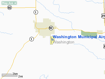
Washington Municipal Airport |
|
|
Location &
QuickFacts
|
FAA
Information Effective: |
2007-07-05 |
|
Airport
Identifier: |
AWG |
|
Airport
Status: |
Operational |
|
Longitude/Latitude: |
091-40-24.3980W/41-16-33.9630N
-91.673444/41.276101 (Estimated) |
|
Elevation: |
754 ft / 229.82 m (Surveyed) |
|
Land: |
160 acres |
|
From
nearest city: |
2 nautical miles SE of Washington, IA |
|
Location: |
Washington County, IA |
|
Magnetic Variation: |
02E (1985) |
Owner & Manager
|
Ownership: |
Publicly owned |
|
Owner: |
City Of Washington |
|
Address: |
215 E Washington
Washington, IA 52353 |
|
Phone
number: |
319-653-6584 |
|
Manager: |
Mike Roe
AIRPORT COMMISSION CHAIR |
|
Address: |
1625 South Airport Rd
Washington, IA 52353 |
|
Phone number: |
319-653-2266 |
Airport Operations and Facilities
|
Airport
Use: |
Open to public |
|
Wind
indicator: |
Yes |
|
Segmented Circle: |
No |
|
Control
Tower: |
No |
|
Lighting
Schedule: |
DUSK-DAWN
ACTVT MIRL RY 13/31 (MED INTST ONLY); MIRL RY 18/36; PAPI RYS 18 & 36
AND REIL RYS 18 & 36 - CTAF. |
|
Beacon
Color: |
Clear-Green (lighted land airport) |
|
Landing
fee charge: |
No |
|
Sectional chart: |
Chicago |
|
Region: |
ACE - Central |
|
Boundary
ARTCC: |
ZAU - Chicago |
|
Tie-in
FSS: |
FOD - Fort Dodge |
|
FSS on
Airport: |
No |
|
FSS
Phone: |
515-955-8114 |
|
FSS Toll
Free: |
1-800-WX-BRIEF |
|
NOTAMs
Facility: |
AWG (NOTAM-d service avaliable) |
|
Federal Agreements: |
NY1 |
Airport Communications
|
CTAF: |
122.700 |
|
Unicom: |
122.700 |
Airport Services
|
Fuel
available: |
100LLA
FUEL AVBL 24 HRS BY CREDIT CARD OR CALL 319-653-2266 FOR AFTER HRS
ASSISTANCE. |
|
Airframe
Repair: |
MAJOR |
|
Power
Plant Repair: |
MAJOR |
|
Bottled
Oxygen: |
NONE |
|
Bulk
Oxygen: |
NONE |
|
Runway Information
Runway 13/31
|
Dimension: |
3401 x 50 ft / 1036.6 x 15.2 m |
|
Surface: |
CONC, Fair Condition |
|
Weight Limit: |
Single wheel: 28000 lbs. |
|
Edge Lights: |
Non-standard lighting system
NSTD MIRL; EDGE LGTS 20 FT FM PAVEMENT EDGE. |
|
|
Runway 13
|
Runway 31
|
|
Longitude: |
091-40-40.2600W |
091-40-08.6300W |
|
Latitude: |
41-16-45.9000N |
41-16-22.2600N |
|
Elevation: |
752.00 ft |
753.00 ft |
|
Alignment: |
127 |
127 |
|
Traffic
Pattern: |
Left |
Left |
|
Markings: |
Non-precision instrument, Good Condition |
Non-precision instrument, Good Condition |
|
Displaced
threshold: |
0.00 ft |
335.00 ft |
|
Obstruction: |
150 ft tower, 7500.0 ft from runway, 200 ft left of
centerline, 48:1 slope to clear |
48 ft trees, 745.0 ft from runway, 485 ft left of
centerline, 11:1 slope to clear
APCH SLOPE 23:1 TO DSPLCD THLD.
+16 FT ROAD 175 FT ON CNTRLN EXTDD. +10 FT ROAD 50 FT ON CNTRLN EXTDD. |
|
Runway 18/36
|
Dimension: |
4000 x 75 ft / 1219.2 x 22.9 m |
|
Surface: |
CONC, Good Condition |
|
Surface
Treatment: |
Wire Comb or Wire Tine |
|
Edge Lights: |
Medium
NSTD MIRL; EDGE LGTS 20 FT FM PAVEMENT EDGE. |
|
|
Runway 18
|
Runway 36
|
|
Longitude: |
091-40-34.6200W |
091-40-37.4300W |
|
Latitude: |
41-16-46.5500N |
41-16-07.0800N |
|
Elevation: |
751.00 ft |
751.00 ft |
|
Alignment: |
127 |
3 |
|
Traffic
Pattern: |
Left |
Left |
|
Markings: |
Non-precision instrument, Good Condition |
Non-precision instrument, Good Condition |
|
Crossing
Height: |
25.00 ft |
25.00 ft |
|
VASI: |
2-light PAPI on right side |
2-light PAPI on left side |
|
Visual
Glide Angle: |
3.00° |
3.00° |
|
Runway End
Identifier: |
Yes |
Yes |
|
Obstruction: |
142 ft tower, 5200.0 ft from runway, 280 ft right of
centerline, 35:1 slope to clear |
, 50:1 slope to clear |
|
Radio Navigation Aids
|
ID |
Type |
Name |
Ch |
Freq |
Var |
Dist |
|
AWG |
NDB |
Washington |
|
219.00 |
02E |
0.2 nm |
|
MPZ |
NDB |
Mount Pleasant |
|
212.00 |
02E |
21.4 nm |
|
FFL |
NDB |
Fairfield |
|
332.00 |
03E |
21.4 nm |
|
OOA |
NDB |
Oskaloosa |
|
414.00 |
03E |
36.9 nm |
|
TZT |
NDB |
Belle Plaine |
|
371.00 |
02E |
45.8 nm |
|
BEX |
NDB |
Bloomfield |
|
269.00 |
02E |
46.9 nm |
|
EOK |
NDB |
Keokuk |
|
366.00 |
02E |
50.0 nm |
|
DDD |
VOR/DME |
Port City |
112X |
116.50 |
01E |
24.3 nm |
|
OTM |
VOR/DME |
Ottumwa |
053X |
111.60 |
06E |
33.1 nm |
|
CID |
VOR/DME |
Cedar Rapids |
088X |
114.10 |
05E |
37.1 nm |
|
IOW |
VORTAC |
Iowa City |
109X |
116.20 |
05E |
14.8 nm |
|
MZV |
VORTAC |
Moline |
091X |
114.40 |
05E |
46.8 nm |
|
BRL |
VORTAC |
Burlington |
051X |
111.40 |
05E |
47.5 nm |
Remarks
-
RY 36 IS CALM
WIND RY.
-
GCO AVBL ON FREQ
121.725 THRU FOD AFSS.
-
CONDL: PROVIDED A
CLEAR APPROACH TO EACH RWY IS MAINTAINED FOR A MINIMUM 20:1 GLIDE SLOPE AND
THE TRANSITIONAL SURFACE IS MAINTAINED FOR A 7:1 SLOPE.
Based
Aircraft
|
Aircraft based
on field: |
27 |
|
Single Engine
Airplanes: |
21 |
|
Multi Engine
Airplanes: |
5 |
|
Ultralights: |
1 |
Operational Statistics
Time Period:
2005-05-18 -
2006-05-17
|
Aircraft
Operations: |
272/Week |
|
General
Aviation Local: |
43.2% |
|
General
Aviation Itinerant: |
56.8% |
Washington Municipal Airport
Address:
Washington County, IA
Tel:
319-653-6584,
319-653-2266
Images
and information placed above are from
http://www.airport-data.com/airport/AWG/
We
thank them for the data!
|
General Info |
| Country |
United
States |
| State |
IOWA
|
| FAA ID |
AWG
|
| Latitude |
41-16-33.963N |
|
Longitude |
091-40-24.398W |
|
Elevation |
754 feet
|
| Near
City |
WASHINGTON |
We don't guarantee the information is fresh and accurate. The data may
be wrong or outdated.
For more up-to-date information please refer to other sources.
|
|


