 |
|
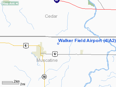
Location &
QuickFacts
|
FAA
Information Effective: |
2007-07-05 |
|
Airport
Identifier: |
4IA2 |
|
Airport
Status: |
Operational |
|
Longitude/Latitude: |
091-13-12.5670W/41-35-10.0850N
-91.220157/41.586135 (Estimated) |
|
Elevation: |
715 ft / 217.93 m (Estimated) |
|
Land: |
4 acres |
|
From
nearest city: |
2 nautical miles NE of West Liberty, IA |
|
Location: |
Muscatine County, IA |
|
Magnetic Variation: |
01E (1995) |
Owner & Manager
|
Ownership: |
Privately owned |
|
Owner: |
John Walker |
|
Address: |
1039 Hayes Avenue
West Liberty, IA 52776 |
|
Phone
number: |
319-627-2268 |
|
Manager: |
John Walker |
|
Address: |
1039 Hayes Avenue
West Liberty, IA 52776 |
|
Phone number: |
319-627-2268 |
Airport Operations and Facilities
|
Airport
Use: |
Private |
|
Wind
indicator: |
Yes |
|
Segmented Circle: |
No |
|
Control
Tower: |
No |
|
Sectional chart: |
Chicago |
|
Region: |
ACE - Central |
|
Boundary
ARTCC: |
ZAU - Chicago |
|
Tie-in
FSS: |
FOD - Fort Dodge |
|
FSS on
Airport: |
No |
|
FSS
Phone: |
515-955-8114 |
|
FSS Toll
Free: |
1-800-WX-BRIEF |
|
Runway Information
Runway 18/36
|
Dimension: |
2300 x 66 ft / 701.0 x 20.1 m |
|
Surface: |
TURF, |
|
|
Runway 18
|
Runway 36
|
|
Traffic
Pattern: |
Left |
Left |
|
Obstruction: |
|
8 ft trees, 200.0 ft from runway |
|
Radio Navigation Aids
|
ID |
Type |
Name |
Ch |
Freq |
Var |
Dist |
|
AWG |
NDB |
Washington |
|
219.00 |
02E |
27.5 nm |
|
OQW |
NDB |
Maquoketa |
|
386.00 |
02E |
35.3 nm |
|
MXO |
NDB |
Monticello |
|
397.00 |
01E |
37.1 nm |
|
MPZ |
NDB |
Mount Pleasant |
|
212.00 |
02E |
40.8 nm |
|
CWI |
NDB |
Clinton |
|
377.00 |
01E |
42.6 nm |
|
FFL |
NDB |
Fairfield |
|
332.00 |
03E |
49.0 nm |
|
DDD |
VOR/DME |
Port City |
112X |
116.50 |
01E |
13.6 nm |
|
CID |
VOR/DME |
Cedar Rapids |
088X |
114.10 |
05E |
31.2 nm |
|
IOW |
VORTAC |
Iowa City |
109X |
116.20 |
05E |
18.1 nm |
|
MZV |
VORTAC |
Moline |
091X |
114.40 |
05E |
30.7 nm |
|
CVA |
VORTAC |
Davenport |
085X |
113.80 |
04E |
33.9 nm |
|
DVN |
VOT |
Davenport Municipal |
|
111.80 |
|
28.6 nm |
Remarks
-
MINIMUM 20:1
GLIDE SLOPE; TREES PENETRATE 20:1 BY 55 FT; MAINTAIN TRANSITIONAL SURFACE FOR
7:1 SLOPE.
Based Aircraft
|
Aircraft based
on field: |
2 |
|
Single Engine
Airplanes: |
1 |
|
Multi Engine
Airplanes: |
1 |
Walker Field Airport
Address:
Muscatine County, IA
Tel:
319-627-2268
Images
and information placed above are from
http://www.airport-data.com/airport/4IA2/
We
thank them for the data!
|
General Info |
| Country |
United
States |
| State |
IOWA
|
| FAA ID |
4IA2
|
| Latitude |
41-35-10.085N |
|
Longitude |
091-13-12.567W |
|
Elevation |
715 feet
|
| Near
City |
WEST
LIBERTY |
We don't guarantee the information is fresh and accurate. The data may
be wrong or outdated.
For more up-to-date information please refer to other sources.
|
|


