 |
|
Vinton Veterans Memorial Airpark Airport |
|
|
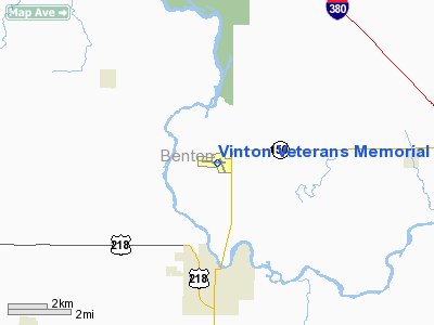
Location &
QuickFacts
|
FAA
Information Effective: |
2007-07-05 |
|
Airport
Identifier: |
VTI |
|
Airport
Status: |
Operational |
|
Longitude/Latitude: |
092-01-33.3410W/42-13-07.0540N
-92.025928/42.218626 (Estimated) |
|
Elevation: |
845 ft / 257.56 m (Estimated) |
|
Land: |
232 acres |
|
From
nearest city: |
3 nautical miles N of Vinton, IA |
|
Location: |
Benton County, IA |
|
Magnetic Variation: |
03E (1985) |
Owner & Manager
|
Ownership: |
Publicly owned |
|
Owner: |
City Of Vinton |
|
Address: |
Po Box 529
Vinton, IA 52349 |
|
Phone
number: |
319-472-4707 |
|
Manager: |
Darrell Kinney
CHAIRMAN, ARPT CMSN.
MGR NOT
AT FIELD. |
|
Address: |
City Hall - P.o. Box 529
Vinton, IA 52349 |
|
Phone number: |
319-472-3722
ARPT PHONE 319-849-2022 OR 319-472-2758. |
Airport
Operations and Facilities
|
Airport
Use: |
Open to public |
|
Wind
indicator: |
Yes |
|
Segmented Circle: |
No |
|
Control
Tower: |
No |
|
Lighting
Schedule: |
DUSK-DAWN
MIRL RY 09/27 PRESET ON LOW INTST; TO INCR INTST & ACTVT PAPI RYS 09 &
27 AND REIL RYS 09 & 27 - CTAF. |
|
Beacon
Color: |
Clear-Green (lighted land airport) |
|
Landing
fee charge: |
No |
|
Sectional chart: |
Chicago |
|
Region: |
ACE - Central |
|
Boundary
ARTCC: |
ZAU - Chicago |
|
Tie-in
FSS: |
FOD - Fort Dodge |
|
FSS on
Airport: |
No |
|
FSS
Phone: |
515-955-8114 |
|
FSS Toll
Free: |
1-800-WX-BRIEF |
|
NOTAMs
Facility: |
VTI (NOTAM-d service avaliable) |
|
Federal Agreements: |
NGY |
Airport Communications
|
CTAF: |
122.800 |
|
Unicom: |
122.800 |
Airport Services
|
Fuel
available: |
100LL
SELF-SERVE FUEL AVBL 24 HRS. |
|
Airframe
Repair: |
MINOR |
|
Power
Plant Repair: |
MINOR |
|
Bottled
Oxygen: |
NONE |
|
Bulk
Oxygen: |
NONE |
|
Runway Information
Runway 09/27
|
Dimension: |
4000 x 60 ft / 1219.2 x 18.3 m |
|
Surface: |
CONC, Good Condition |
|
Edge Lights: |
Non-standard lighting system
RY 09/27 - NSTD MIRL; LGTS CLEAR ON BOTH ENDS. |
|
|
Runway 09
|
Runway 27
|
|
Longitude: |
092-02-07.4100W |
092-01-14.1600W |
|
Latitude: |
42-13-10.2600N |
42-13-08.5300N |
|
Elevation: |
824.00 ft |
838.00 ft |
|
Traffic
Pattern: |
Left |
Left |
|
Markings: |
Non-precision instrument, Fair Condition |
Non-precision instrument, Fair Condition |
|
VASI: |
2-light PAPI on left side |
2-light PAPI on left side |
|
Visual
Glide Angle: |
4.00° |
3.00° |
|
Runway End
Identifier: |
Yes |
Yes |
|
Obstruction: |
74 ft trees, 1660.0 ft from runway, 50 ft right of
centerline, 19:1 slope to clear |
31 ft trees, 1005.0 ft from runway, 235 ft right of
centerline, 25:1 slope to clear |
|
Runway 16/34
|
Dimension: |
2500 x 50 ft / 762.0 x 15.2 m |
|
Surface: |
ASPH, Good Condition |
|
Weight Limit: |
Single wheel: 12500 lbs. |
|
|
Runway 16
|
Runway 34
|
|
Longitude: |
092-01-34.0400W |
092-01-23.1100W |
|
Latitude: |
42-13-22.5700N |
42-12-59.2500N |
|
Elevation: |
838.00 ft |
839.00 ft |
|
Alignment: |
127 |
127 |
|
Traffic
Pattern: |
Left |
Left |
|
Markings: |
Basic, Good Condition |
, |
|
Displaced
threshold: |
0.00 ft |
200.00 ft |
|
Obstruction: |
, 50:1 slope to clear |
28 ft trees, 588.0 ft from runway, 142 ft right of
centerline, 13:1 slope to clear |
|
Radio Navigation Aids
|
ID |
Type |
Name |
Ch |
Freq |
Var |
Dist |
|
VTI |
NDB |
Garrison |
|
338.00 |
03E |
0.3 nm |
|
IIB |
NDB |
Wapsie |
|
206.00 |
02E |
14.4 nm |
|
TZT |
NDB |
Belle Plaine |
|
371.00 |
02E |
23.1 nm |
|
OLZ |
NDB |
Oelwein |
|
260.00 |
02E |
28.1 nm |
|
MXO |
NDB |
Monticello |
|
397.00 |
01E |
39.6 nm |
|
MIW |
NDB |
Marshalltown |
|
239.00 |
03E |
40.2 nm |
|
GGI |
NDB |
Grinnell |
|
248.00 |
02E |
43.9 nm |
|
XWY |
NDB |
West Union |
|
278.00 |
02E |
44.9 nm |
|
CID |
VOR/DME |
Cedar Rapids |
088X |
114.10 |
05E |
22.6 nm |
|
JWJ |
VOR/DME |
Elmwood |
031X |
109.40 |
03E |
39.9 nm |
|
ALO |
VORTAC |
Waterloo |
059X |
112.20 |
06E |
26.2 nm |
|
IOW |
VORTAC |
Iowa City |
109X |
116.20 |
05E |
45.9 nm |
Remarks
-
RY 16/34 CLSD
NIGHTS AND USED AS TWY FM RY 09/27 TO RAMP; TWY EDGE LGTS 30 FT FM PAVEMENT
EDGES.
-
COURTESY CAR AVAILABLE.
Based Aircraft
|
Aircraft based
on field: |
22 |
|
Single Engine
Airplanes: |
22 |
Operational Statistics
Time Period:
2005-06-27 -
2006-06-26
|
Aircraft
Operations: |
75/Week |
|
General
Aviation Local: |
43.2% |
|
General
Aviation Itinerant: |
56.8% |
Vinton Veterans Memorial Airpark Airport
Address:
Benton County, IA
Tel:
319-472-4707,
319-472-3722
Images
and information placed above are from
http://www.airport-data.com/airport/VTI/
We
thank them for the data!
|
General Info |
| Country |
United
States |
| State |
IOWA
|
| FAA ID |
VTI
|
| Latitude |
42-13-07.054N |
|
Longitude |
092-01-33.341W |
|
Elevation |
845 feet
|
| Near
City |
VINTON
|
We don't guarantee the information is fresh and accurate. The data may
be wrong or outdated.
For more up-to-date information please refer to other sources.
|
|


