 |
|
|
|
|
|
Location &
QuickFacts
|
FAA
Information Effective: |
2007-07-05 |
|
Airport
Identifier: |
8C5 |
|
Airport
Status: |
Operational |
|
Longitude/Latitude: |
092-32-52.7501W/41-59-17.6338N
-92.547986/41.988232 (Estimated) |
|
Elevation: |
960 ft / 292.61 m (Surveyed) |
|
Land: |
10 acres |
|
From
nearest city: |
2 nautical miles E of Toledo, IA |
|
Location: |
Tama County, IA |
|
Magnetic Variation: |
03E (1985) |
Owner & Manager
|
Ownership: |
Publicly owned |
|
Owner: |
City Of Toledo |
|
Address: |
City Clerk 103 S Church
Toledo, IA 52342 |
|
Phone
number: |
515-484-2160 |
|
Manager: |
Jeff Else
OTHER CONTACT: KEITH HANUS 515-484-3443 |
|
Address: |
401 S. Elm
Toledo, IA 52342 |
|
Phone number: |
515-484-3433 |
Airport
Operations and Facilities
|
Airport
Use: |
Open to public |
|
Wind
indicator: |
Yes |
|
Segmented Circle: |
No |
|
Control
Tower: |
No |
|
Lighting
Schedule: |
DUSK-DAWN |
|
Beacon
Color: |
Clear-Green (lighted land airport) |
|
Landing
fee charge: |
No |
|
Sectional chart: |
Chicago |
|
Region: |
ACE - Central |
|
Traffic
Pattern Alt: |
800 ft |
|
Boundary
ARTCC: |
ZAU - Chicago |
|
Tie-in
FSS: |
FOD - Fort Dodge |
|
FSS on
Airport: |
No |
|
FSS
Phone: |
515-955-8114 |
|
FSS Toll
Free: |
1-800-WX-BRIEF |
|
NOTAMs
Facility: |
FOD (NOTAM-d service avaliable) |
Airport Communications
|
Runway Information
Runway 17/35
|
Dimension: |
1850 x 100 ft / 563.9 x 30.5 m |
|
Surface: |
TURF, Fair Condition |
|
|
Runway 17
|
Runway 35
|
|
Traffic
Pattern: |
Left |
Left |
|
Displaced
threshold: |
0.00 ft |
395.00 ft |
|
Obstruction: |
35 ft tree, 720.0 ft from runway, 150 ft right of
centerline, 20:1 slope to clear |
28 ft pole, 445.0 ft from runway, 100 ft right of
centerline, 15:1 slope to clear
RWY 35 APCH SLOPE 41:1 TO DSPLCD THLD. |
|
Radio Navigation Aids
|
ID |
Type |
Name |
Ch |
Freq |
Var |
Dist |
|
TZT |
NDB |
Belle Plaine |
|
371.00 |
02E |
13.4 nm |
|
MIW |
NDB |
Marshalltown |
|
239.00 |
03E |
18.0 nm |
|
GGI |
NDB |
Grinnell |
|
248.00 |
02E |
18.6 nm |
|
VTI |
NDB |
Garrison |
|
338.00 |
03E |
27.4 nm |
|
IIB |
NDB |
Wapsie |
|
206.00 |
02E |
38.5 nm |
|
PEA |
NDB |
Pella |
|
257.00 |
02E |
39.3 nm |
|
IFA |
NDB |
Iowa Falls |
|
368.00 |
03E |
43.4 nm |
|
OOA |
NDB |
Oskaloosa |
|
414.00 |
03E |
45.9 nm |
|
IKV |
NDB |
Ankeny |
|
275.00 |
03E |
48.7 nm |
|
OXV |
NDB |
Knoxville |
|
284.00 |
03E |
48.8 nm |
|
OLZ |
NDB |
Oelwein |
|
260.00 |
02E |
48.9 nm |
|
JWJ |
VOR/DME |
Elmwood |
031X |
109.40 |
03E |
17.7 nm |
|
TNU |
VOR/DME |
Newton |
072X |
112.50 |
03E |
27.9 nm |
|
CID |
VOR/DME |
Cedar Rapids |
088X |
114.10 |
05E |
34.6 nm |
|
ALO |
VORTAC |
Waterloo |
059X |
112.20 |
06E |
34.8 nm |
Remarks
-
175 FT BY 25 FT
ASPH STRIP AT THE AER 17 USED AS TWY.
-
ARPT CLSD SS-SR.
Based Aircraft
|
Aircraft based
on field: |
4 |
|
Single Engine
Airplanes: |
4 |
Operational Statistics
Time Period:
2005-09-27 -
2006-09-26
|
Aircraft
Operations: |
33/Week |
|
General
Aviation Local: |
64.7% |
|
General
Aviation Itinerant: |
35.3% |
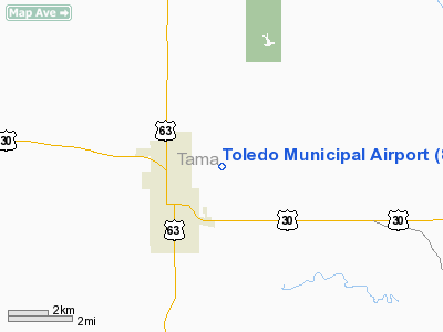
Toledo Municipal Airport
Address:
Tama County, IA
Tel:
515-484-2160,
515-484-3433
Images
and information placed above are from
http://www.airport-data.com/airport/8C5/
We
thank them for the data!
|
General Info |
| Country |
United
States |
| State |
IOWA
|
| FAA ID |
8C5
|
| Latitude |
41-59-29.969N |
|
Longitude |
092-33-42.693W |
|
Elevation |
960 feet
|
| Near
City |
TOLEDO
|
We don't guarantee the information is fresh and accurate. The data may
be wrong or outdated.
For more up-to-date information please refer to other sources.
|
|


