|
|
The Eastern Iowa Airport
 |
 |
| IATA: CID â ICAO: KCID
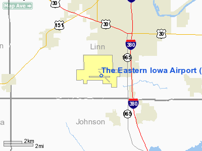
Location of the Eastern Iowa Airport
|
| Summary |
| Airport type |
Public |
| Operator |
Cedar Rapids Airport Commission |
| Location |
Cedar Rapids, Iowa |
| Elevation AMSL |
869 ft / 264.9 m |
| Coordinates |
41°53â²04.9â³N 91°42â²38.9â³W / 41.884694°N 91.710806°W / 41.884694; -91.710806 |
| Runways |
| Direction |
Length |
Surface |
| ft |
m |
| 9/27 |
8,601 |
2,622 |
Asphalt/Concrete |
| 13/31 |
6,200 |
1,890 |
Asphalt/Concrete |
The Eastern Iowa Airport (IATA: CID, ICAO: KCID) is a commercial airport in Cedar Rapids, Iowa, in the United States. The airport serves Cedar Rapids, Iowa City, and other communities in eastern Iowa. It is located along Wright Brothers Boulevard on the southern edge of Cedar Rapids, about two miles (3.2 kilometers) west of Interstate 380. Passenger experience
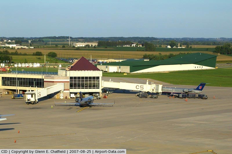
This airport is served almost entirely by regional jets. MD-80 jet service is provided by Allegiant Air; American, Delta and United use all regional jets to their hubs from the Eastern Iowa Airport. The airport is served by five airlines with non-stop flights to nine destinations. The airport is mid-sized, with 14 gates; Six gates on the upper concourse (C) are equipped with jet bridge boarding and Gates B1-B7 are ground level boarding areas.
In the pre-security area, there is the Sam Adams Brewhouse with a full-service menu or grab-n-go items including Pizza Hut Express. There is also a gift shop, and a locally-owned coffee shop, Blue Strawberry located with the Corridor Concierge, also referred to as the information center where visitors can ask questions about the airport or receive tourist-related information. A small exhibit on the airport's history is also near check-in.
Usually, the longest a passenger has to wait in the security line is five minutes. However, at busier times of the year like the holidays and spring break, as well as the early morning bank of flights outbound to the hubs between 5am-8am, lines can be longer. Upstairs on the concourse, or past the security checkpoint, construction is underway for the Millstream Brewhaus, which will feature beer made at the Millstream Brewery in the Amana Colonies. A kiosk will be placed on the concourse where various items will be sold.
For arriving passengers, this airport's small size provides a short walk to the baggage claim area. Also, there are several national rental car company counters, and a courtesy shuttle counter in this area.
On 25 August 2009, The Eastern Iowa Airport reduced its number of destinations to nine. Delta ended all regularly scheduled service to Atlanta and Cincinnati on 18 August 2009. Service is now routed through its Detroit and Minneapolis hubs. Meanwhile, the airport's St. Louis service ended after 52 years when American stopped flying between the two cities on 25 August 2009.[1]
Runway Reconstruction
On 3 June 2010, The Eastern Iowa Airport closed Runway 9/27 for reconstruction. The closure lasted until 23 September 2010 when the runway reopened. A temporary runway had been set up parallel to the closed runway. Beginning 3 July 2010 and lasting for 4 weeks, Runway 13/31 was also closed as they reconstructed the intersection with Runway 9/27. [2]
History
Cedar Rapids' first airport was Hunter Field, a private airport established by Dan Hunter in the 1920s. It was located along Bowling Street SW north of U.S. Highway 30. The airport was originally used for private charter service, pilot training, and airmail, but it was inoperable during bad weather. This led to the need for a new airport.
The Cedar Rapids Municipal Airport was completed with military funding in 1944 but was not officially dedicated until April 27, 1947. The Cedar Rapids Parks Department operated the airport until a new Airport Commission was established in 1945; Donald Hines, who led the effort to build the airport, was the commission's director until he retired in 1973 (he died in 1975). Scheduled east-west passenger service from United Airlines began in 1947, and north-south passenger service from Ozark Airlines began in 1957. By 1969, the airport handled 31 commercial flights per day and recorded 353,000 passengers a year.
The present terminal was dedicated in 1986 with a ceremony that U.S. Secretary of Transportation Elizabeth Dole attended. The Cedar Rapids Airport was renamed The Eastern Iowa Airport in 1997 in order to reflect its status as a regional airport. In 2000 the airport enplaned and deplaned one million passengers for the first time in its history; it set a record in 2005 with 1,004,434 passengers. [3]
Airlines and destinations
Eastern Iowa Airport consists of two passenger concourses: Concourse B with gates B1 - B7, and Concourse C with gates C1 - C6.
| Airlines |
Destinations |
Concourse |
| Allegiant Air |
Las Vegas, Orlando-Sanford, Phoenix/Mesa, St. Petersburg/Clearwater |
B |
| American Eagle |
Dallas/Fort Worth |
C |
| AmericanConnection operated by Chautauqua Airlines |
Chicago-O'Hare |
C |
| Delta Connection operated by Mesaba Airlines |
Detroit, Minneapolis/St. Paul |
C |
| Delta Connection operated by Pinnacle Airlines |
Detroit, Minneapolis/St. Paul |
C |
| United Express operated by Mesa Airlines |
Chicago-O'Hare |
C |
| United Express operated by Shuttle America |
Chicago-O'Hare |
C |
| United Express operated by SkyWest Airlines |
Chicago-O'Hare, Denver |
C |
| United Express operated by Trans States Airlines |
Denver |
C |
Cargo Airlines
| Airlines |
Destinations |
| Ameriflight |
Cincinnati, Omaha |
| Cap City |
Davenport, St. Paul Downtown |
| Central Airlines |
Minneapolis Flying Cloud, Kansas City Downtown |
| FedEx Express |
Des Moines, Indianapolis, Memphis, Madison |
| Planemaster |
Spencer |
| UPS |
Des Moines, Louisville |
Airport Management
- Dan Mann : A.A.E., Airport Director
- Donald D. Swanson : Director of Finance & Administration
- Sara Mau : A.A.E., Director of Operations
- Pam Hinman : Director of Marketing & Communications
- Kathleen A. Bell : Deputy Director of Finance & Administration
The above content comes from Wikipedia and is published under free licenses – click here to read more.
|
 |
(Click on the photo to enlarge) |
|
 |
(Click on the photo to enlarge) |
|
 |
(Click on the photo to enlarge) |
|
 |
(Click on the photo to enlarge) |
Location &
QuickFacts
|
FAA
Information Effective: |
2007-07-05 |
|
Airport
Identifier: |
CID |
|
Airport
Status: |
Operational |
|
Longitude/Latitude: |
091-42-38.8753W/41-53-04.8805N
-91.710799/41.884689 (Estimated) |
|
Elevation: |
869 ft / 264.87 m (Surveyed) |
|
Land: |
3288 acres |
|
From
nearest city: |
6 nautical miles SW of Cedar Rapids, IA |
|
Location: |
Linn County, IA |
|
Magnetic Variation: |
02E (1985) |
Owner & Manager
|
Ownership: |
Publicly owned |
|
Owner: |
City Of Cedar Rapids |
|
Address: |
City Hall, 2nd Ave Island
Cedar Rapids, IA 52406 |
|
Phone
number: |
319-286-5051 |
|
Manager: |
Mr. Dan Mann, A.a.e. |
|
Address: |
2515 Arthur Collins Pkwy Sw
Cedar Rapids, IA 52404-8952 |
|
Phone number: |
319-362-3131 |
Airport Operations and Facilities
|
Airport
Use: |
Open to public |
|
Wind
indicator: |
Yes |
|
Segmented Circle: |
No |
|
Control
Tower: |
Yes |
|
Lighting
Schedule: |
DUSK-DAWN
WHEN ATCT CLSD ACTVT PAPI RYS 09 & 27; MALSR RYS 09 & 27 (2330-0500) &
TWY LGTS - CTAF. RY 09/27 EDGE LGTS PRESET STEP 2; TO INCR INTST ACTVT
- CTAF. MIRL RY 13/31; REIL RY 13; VASI RY 31 & PAPI RY 13 & MALSR RY
31 NOT AVBL WHEN ATCT CLSD. |
|
Beacon
Color: |
Clear-Green (lighted land airport) |
|
Landing
fee charge: |
No |
|
Sectional chart: |
Chicago |
|
Region: |
ACE - Central |
|
Traffic
Pattern Alt: |
1000 ft |
|
Boundary
ARTCC: |
ZAU - Chicago |
|
Tie-in
FSS: |
FOD - Fort Dodge |
|
FSS on
Airport: |
No |
|
FSS
Phone: |
515-955-8114 |
|
FSS Toll
Free: |
1-800-WX-BRIEF |
|
NOTAMs
Facility: |
CID (NOTAM-d service avaliable) |
|
Certification type/date: |
I B S 05/1973
INDEX C LEVEL ARFF AVAILABLE UPON REQUEST WITH 48 HRS NOTICE.
319-366-2246 |
|
Federal
Agreements: |
NGY3 |
Airport
Communications
|
CTAF: |
118.700 |
|
Unicom: |
122.950 |
Airport Services
|
Fuel
available: |
100LLA
FOR FUEL SVC AFTER HRS CALL 319-366-2246. |
|
Airframe
Repair: |
MAJOR |
|
Power
Plant Repair: |
MAJOR |
|
Bottled
Oxygen: |
HIGH/LOW |
|
Bulk
Oxygen: |
HIGH/LOW |
|
Runway Information
Runway 09/27
|
Dimension: |
8601 x 150 ft / 2621.6 x 45.7 m
2200 FT CONC WEST END. |
|
Surface: |
ASPH-CONC, Fair Condition |
|
Surface
Treatment: |
Saw-cut or plastic Grooved |
|
Weight Limit: |
Single wheel: 100000 lbs.
Dual wheel: 174000 lbs.
Dual tandem wheel: 300000 lbs. |
|
Edge Lights: |
High |
|
|
Runway 09
|
Runway 27
|
|
Longitude: |
091-43-45.0062W |
091-41-51.3273W |
|
Latitude: |
41-53-04.7427N |
41-53-03.3773N |
|
Elevation: |
852.00 ft |
860.00 ft |
|
Alignment: |
91 |
127 |
|
ILS Type: |
ILS |
ILS/DME |
|
Traffic
Pattern: |
Left |
Left |
|
Markings: |
Precision instrument, Good Condition |
Precision instrument, Good Condition |
|
Crossing
Height: |
0.00 ft |
49.00 ft |
|
Displaced
threshold: |
0.00 ft |
425.00 ft |
|
VASI: |
4-light PAPI on right side |
4-light PAPI on left side
PAPI RESTRICTED TO 5 DEGS RIGHT & LEFT OF CNTRLN. |
|
Visual
Glide Angle: |
0.00° |
3.00° |
|
RVR
Equipment: |
touchdown |
touchdown |
|
Approach
lights: |
MALSR |
MALSR |
|
Runway End
Identifier: |
|
No |
|
Obstruction: |
, 50:1 slope to clear |
14 ft rr, 740.0 ft from runway, 39:1 slope to clear |
|
Decleard
distances: |
Take off run available 8601.00 ft
Take off distance available 8601.00 ft
Actual stop distance available 8176.00 ft
Landing distance available 8176.00 ft |
Take off run available 8601.00 ft
Take off distance available 8601.00 ft
Actual stop distance available 8601.00 ft
Landing distance available 8176.00 ft |
|
Runway 13/31
|
Dimension: |
6200 x 150 ft / 1889.8 x 45.7 m
2200 FT CONC WEST END. |
|
Surface: |
ASPH-CONC, |
|
Surface
Treatment: |
Saw-cut or plastic Grooved |
|
Weight Limit: |
Single wheel: 100000 lbs.
Dual wheel: 174000 lbs.
Dual tandem wheel: 300000 lbs. |
|
Edge Lights: |
Medium |
|
|
Runway 13
|
Runway 31
|
|
Longitude: |
091-42-54.4832W |
091-41-57.4881W |
|
Latitude: |
41-53-28.0238N |
41-52-44.0137N |
|
Elevation: |
869.00 ft |
848.00 ft |
|
Alignment: |
127 |
127 |
|
Traffic
Pattern: |
Left |
Left |
|
Markings: |
Non-precision instrument, Good Condition |
Non-precision instrument, Good Condition |
|
Crossing
Height: |
51.00 ft |
43.00 ft |
|
VASI: |
4-light PAPI on left side |
4-box on left side |
|
Visual
Glide Angle: |
3.00° |
3.00° |
|
Approach
lights: |
|
MALSR |
|
Runway End
Identifier: |
Yes |
|
|
Decleard
distances: |
Take off run available 6200.00 ft
Take off distance available 6200.00 ft
Actual stop distance available 6200.00 ft
Landing distance available 6200.00 ft |
Take off run available 6200.00 ft
Take off distance available 6200.00 ft
Actual stop distance available 6200.00 ft
Landing distance available 6200.00 ft |
|
Radio Navigation Aids
|
ID |
Type |
Name |
Ch |
Freq |
Var |
Dist |
|
VTI |
NDB |
Garrison |
|
338.00 |
03E |
24.5 nm |
|
TZT |
NDB |
Belle Plaine |
|
371.00 |
02E |
25.6 nm |
|
MXO |
NDB |
Monticello |
|
397.00 |
01E |
31.9 nm |
|
IIB |
NDB |
Wapsie |
|
206.00 |
02E |
35.8 nm |
|
AWG |
NDB |
Washington |
|
219.00 |
02E |
36.4 nm |
|
OQW |
NDB |
Maquoketa |
|
386.00 |
02E |
44.5 nm |
|
GGI |
NDB |
Grinnell |
|
248.00 |
02E |
46.9 nm |
|
OLZ |
NDB |
Oelwein |
|
260.00 |
02E |
49.5 nm |
|
CID |
VOR/DME |
Cedar Rapids |
088X |
114.10 |
05E |
3.4 nm |
|
DDD |
VOR/DME |
Port City |
112X |
116.50 |
01E |
40.1 nm |
|
IOW |
VORTAC |
Iowa City |
109X |
116.20 |
05E |
22.4 nm |
Remarks
-
BIRDS ON & INVOF ARPT.
-
WHEN ATCT CLSD &
DURING SNOW & ICE EVENTS; ALL ARR/ DEP ACFT ANNOUNCE THEIR INTENTIONS ON CTAF
5 MINS PRIOR TO USING THE RYS. PERSONNEL & EQUIPMENT PERFORMING SNOW & ICE
REMOVAL OPNS WILL MONITOR CTAF.
-
TWY D IS A
NON-MOVEMENT AREA FM TWY B TO THE SAFETY CENTER EXIT.
Based
Aircraft
|
Aircraft based
on field: |
141 |
|
Single Engine
Airplanes: |
115 |
|
Multi Engine
Airplanes: |
11 |
|
Jet Engine
Airplanes: |
11 |
|
Helicopters: |
4 |
Major Carriers Serving
This Airport
|
American Eagle Airlines Inc. |
51.2% |
|
Skywest Airlines Inc. |
22.2% |
|
Comair Inc. |
11.9% |
|
Northwest Airlines Inc. |
8.2% |
|
Atlantic Southeast Airlines |
4.4% |
|
Mesa Airlines Inc. |
2.1% |
Most Popular
Destinations
|
Chicago O'hare Intl (ORD) |
45.3% |
|
Dallas/fort Worth Intl (DFW) |
21.9% |
|
Cincinnati/northern Kentucky Intl (CVG) |
11.9% |
|
Denver Intl (DEN) |
8.4% |
|
Minneapolis-st Paul Intl/wold-chamberlain/ (MSP) |
8.2% |
|
Hartsfield - Jackson Atlanta Intl (ATL) |
4.4% |
Most Popular Aircraft
|
N667GB |
0.7% |
|
N676AE |
0.7% |
|
N933JN |
0.6% |
|
N778SK |
0.6% |
|
N610AE |
0.6% |
|
N678AE |
0.6% |
|
N906AE |
0.6% |
|
N764SK |
0.6% |
|
N801AE |
0.6% |
|
N821AE |
0.6% |
Operational Statistics
Time Period:
2005-09-01 -
2006-08-31
|
Aircraft
Operations: |
173/Day |
|
Commerical: |
12.1% |
|
Air Taxi: |
40.3% |
|
General
Aviation Local: |
11.8% |
|
General
Aviation Itinerant: |
35.5% |
|
Military: |
0.3% |
The Eastern Iowa Airport
Address:
Linn County, IA
Tel:
319-286-5051,
319-362-3131
Images
and information placed above are from
http://www.airport-data.com/airport/CID/
We
thank them for the data!
|
General Info |
| Country |
United
States |
| State |
IOWA
|
| FAA ID |
CID
|
| Latitude |
41-53-04.518N |
|
Longitude |
091-42-39.140W |
|
Elevation |
864 feet
|
| Near
City |
CEDAR
RAPIDS |
We don't guarantee the information is fresh and accurate. The data may
be wrong or outdated.
For more up-to-date information please refer to other sources.
|
|