 |
|
Storm Lake Municipal Airport |
|
|
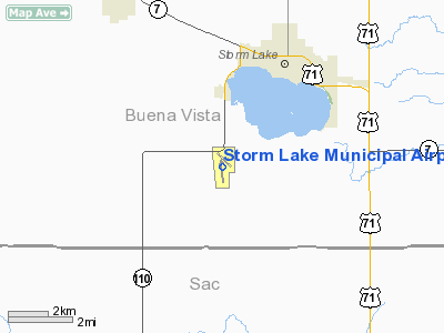
Location &
QuickFacts
|
FAA
Information Effective: |
2007-07-05 |
|
Airport
Identifier: |
SLB |
|
Airport
Status: |
Operational |
|
Longitude/Latitude: |
095-14-26.4000W/42-35-50.1000N
-95.240667/42.597250 (Estimated) |
|
Elevation: |
1488 ft / 453.54 m (Surveyed) |
|
Land: |
160 acres |
|
From
nearest city: |
3 nautical miles SW of Storm Lake, IA |
|
Location: |
Buena Vista County, IA |
|
Magnetic Variation: |
04E (1995) |
Owner & Manager
|
Ownership: |
Publicly owned |
|
Owner: |
City Of Storm Lake |
|
Address: |
City Hall P.o. Box 1086
Storm Lake, IA 50588 |
|
Phone
number: |
712-732-8001 |
|
Manager: |
Jim Bartholomew |
|
Address: |
850 630th St
Storm Lake, IA 50588 |
|
Phone number: |
712-732-6494
EVENING PHONE 712-732-6301 |
Airport Operations and Facilities
|
Airport
Use: |
Open to public |
|
Wind
indicator: |
Yes |
|
Segmented Circle: |
No |
|
Control
Tower: |
No |
|
Lighting
Schedule: |
DUSK-DAWN
ACTVT MIRL RY 13/31 & RY 17/35 & REIL RYS 17 & 35 - CTAF. |
|
Beacon
Color: |
Clear-Green (lighted land airport) |
|
Landing
fee charge: |
No |
|
Sectional chart: |
Omaha |
|
Region: |
ACE - Central |
|
Boundary
ARTCC: |
ZMP - Minneapolis |
|
Tie-in
FSS: |
FOD - Fort Dodge |
|
FSS on
Airport: |
No |
|
FSS
Phone: |
515-955-8114 |
|
FSS Toll
Free: |
1-800-WX-BRIEF |
|
NOTAMs
Facility: |
SLB (NOTAM-d service avaliable) |
|
Federal Agreements: |
N |
Airport Communications
|
CTAF: |
122.700 |
|
Unicom: |
122.700 |
Airport Services
|
Fuel
available: |
100 A |
|
Airframe
Repair: |
MAJOR |
|
Power
Plant Repair: |
MAJOR |
|
Bottled
Oxygen: |
NONE |
|
Bulk
Oxygen: |
NONE |
|
Runway Information
Runway 06/24
|
Dimension: |
1855 x 90 ft / 565.4 x 27.4 m |
|
Surface: |
TURF, Good Condition
CLSD WINTER MONTHS NOV THRU MAR. |
|
|
Runway 06
|
Runway 24
|
|
Longitude: |
095-14-37.8600W |
095-14-15.1200W |
|
Latitude: |
42-35-54.2900N |
42-36-01.5700N |
|
Elevation: |
1488.00 ft |
1488.00 ft |
|
Alignment: |
67 |
127 |
|
Traffic
Pattern: |
Left |
Left |
|
Obstruction: |
6 ft fence, 210.0 ft from runway, 35:1 slope to clear |
, 50:1 slope to clear |
|
Runway 13/31
|
Dimension: |
3034 x 50 ft / 924.8 x 15.2 m |
|
Surface: |
CONC, Good Condition
CLSD WINTER MONTHS NOV THRU MAR. |
|
Weight Limit: |
Single wheel: 4000 lbs. |
|
Edge Lights: |
Medium |
|
|
Runway 13
|
Runway 31
|
|
Longitude: |
095-14-37.3653W |
095-14-08.2271W |
|
Latitude: |
42-36-12.7010N |
42-35-51.8479N |
|
Elevation: |
1477.00 ft |
1467.00 ft |
|
Alignment: |
127 |
127 |
|
Traffic
Pattern: |
Left |
Left |
|
Markings: |
Basic, Good Condition |
Basic, Good Condition |
|
Displaced
threshold: |
172.00 ft |
0.00 ft |
|
Obstruction: |
24 ft road, 460.0 ft from runway, 10:1 slope to clear
APCH RATIO FM DSPLCD THR 26:1. |
, 50:1 slope to clear |
|
Runway 17/35
|
Dimension: |
5000 x 75 ft / 1524.0 x 22.9 m |
|
Surface: |
CONC, Good Condition
CLSD WINTER MONTHS NOV THRU MAR. |
|
Weight Limit: |
Single wheel: 30000 lbs.
Dual wheel: 38000 lbs. |
|
Edge Lights: |
Medium |
|
|
Runway 17
|
Runway 35
|
|
Longitude: |
095-14-31.8929W |
095-14-25.9624W |
|
Latitude: |
42-36-03.8276N |
42-35-14.6211N |
|
Elevation: |
1480.00 ft |
1480.00 ft |
|
Alignment: |
127 |
127 |
|
Traffic
Pattern: |
Left |
Left |
|
Markings: |
Non-precision instrument, Good Condition |
Non-precision instrument, Good Condition |
|
Crossing
Height: |
27.00 ft |
27.00 ft |
|
VASI: |
2-light PAPI on left side |
2-light PAPI on left side |
|
Visual
Glide Angle: |
3.00° |
3.00° |
|
Runway End
Identifier: |
Yes |
Yes |
|
Radio Navigation Aids
|
ID |
Type |
Name |
Ch |
Freq |
Var |
Dist |
|
SLB |
NDB |
Storm Lake |
|
434.00 |
04E |
0.3 nm |
|
CKP |
NDB |
Pilot Rock |
|
423.00 |
05E |
16.0 nm |
|
SKI |
NDB |
Sac City |
|
356.00 |
04E |
17.3 nm |
|
POH |
NDB |
Pocahontas |
|
428.00 |
06E |
27.7 nm |
|
LTU |
NDB |
Little Sioux |
|
326.00 |
05E |
32.2 nm |
|
MEY |
NDB |
Mapleton |
|
335.00 |
05E |
35.1 nm |
|
DNS |
NDB |
Denison |
|
350.00 |
04E |
37.4 nm |
|
EGQ |
NDB |
Emmetsburg |
|
410.00 |
04E |
38.3 nm |
|
CIN |
NDB |
Carroll |
|
397.00 |
04E |
38.9 nm |
|
ORC |
NDB |
Orange City |
|
521.00 |
05E |
43.2 nm |
|
SHL |
NDB |
Sheldon |
|
338.00 |
05E |
45.4 nm |
|
SU |
NDB |
Salix |
|
414.00 |
07E |
49.3 nm |
|
SPW |
VOR/DME |
Spencer |
037X |
110.00 |
05E |
34.0 nm |
|
DDL |
VOR/DME |
Sheldon |
023X |
108.60 |
05E |
45.3 nm |
|
FOD |
VORTAC |
Fort Dodge |
082X |
113.50 |
07E |
41.9 nm |
Remarks
-
GCO AVBL ON FREQ
121.725 THRU FOD AFSS.
-
RY 35 IS CALM
WIND RY.
-
PROVIDED APCH TO
EACH RY CLEAR FOR A 20:1 GLIDE SLOPE & MNTN A CLEAR TRSNL SFC FOR A 7:1 SLOPE.
Based
Aircraft
|
Aircraft based
on field: |
33 |
|
Single Engine
Airplanes: |
32 |
|
Jet Engine
Airplanes: |
1 |
Operational Statistics
Time Period:
2005-07-13 -
2006-07-12
|
Aircraft
Operations: |
291/Week |
|
General
Aviation Local: |
43.2% |
|
General
Aviation Itinerant: |
56.8% |
Storm Lake Municipal Airport
Address:
Buena Vista County, IA
Tel:
712-732-8001,
712-732-6494
Images
and information placed above are from
http://www.airport-data.com/airport/SLB/
We
thank them for the data!
|
General Info |
| Country |
United
States |
| State |
IOWA
|
| FAA ID |
SLB
|
| Latitude |
42-35-49.900N |
|
Longitude |
095-14-26.400W |
|
Elevation |
1488
feet |
| Near
City |
STORM
LAKE |
We don't guarantee the information is fresh and accurate. The data may
be wrong or outdated.
For more up-to-date information please refer to other sources.
|
|


