 |
|
Spencer Municipal Airport |
Spencer Municipal Airport
Northwest Iowa Regional Airport |
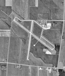 |
| USGS aerial image, 10 April 1991 |
| IATA: SPW â ICAO: KSPW â FAA LID: SPW |
| Summary |
| Airport type |
Public |
| Owner |
City of Spencer |
| Serves |
Spencer, Iowa |
| Location |
Riverton Township, Clay County |
| Elevation AMSL |
1,339 ft / 408 m |
| Coordinates |
43°09â²56â³N 095°12â²10â³W / 43.16556°N 95.20278°W / 43.16556; -95.20278 |
| Website |
SpencerIowaCity.com/... |
| Runways |
| Direction |
Length |
Surface |
| ft |
m |
| 12/30 |
6,000 |
1,829 |
Concrete |
| 18/36 |
5,100 |
1,554 |
Concrete |
| Statistics (2007) |
| Aircraft operations |
15,300 |
| Based aircraft |
36 |
| Source: FAA, airport website |
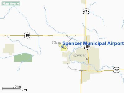
Spencer Municipal Airport (IATA: SPW, ICAO: KSPW, FAA LID: SPW), also known as Northwest Iowa Regional Airport, is a public airport located three miles (5 km) northwest of the central business district of Spencer, a city in Clay County, Iowa, United States. It is owned by the City of Spencer.
The airport is not served by any commercial airlines at this time but it was once the home of Great Lakes Airlines. The airline was named after the nearby Iowa Great Lakes. The airline has since relocated to Cheyenne, Wyoming. History
Opened in March, 1942. Provided contract glider training to the United States Army Air Forces, 1942-1944. Training provided by Hunter Flying Service. An all-way turf airfield with a 4,000' x 4,000' landing/takeoff area. Used primarily C-47 Skytrains and Waco CG-4 unpowered Gliders. The mission of the school was to train glider pilot students in proficiency in operation of gliders in various types of towed and soaring flight, both day and night, and in servicing of gliders in the field.
Inactivated during 1944 with the drawdown of AAFTC's pilot training program. Declared surplus and turned over to the Army Corps of Engineers on 30 September 1945. Eventually discharged to the War Assets Administration (WAA) and became a civil airport.
Facilities and aircraft
Spencer Municipal Airport covers an area of 812 acres (329 ha) which contains two concrete paved runways: 12/30 measuring 6,000 x 100 ft (1,829 x 30 m) and 18/36 measuring 5,100 x 75 ft (1,554 x 23 m).
For the 12-month period ending August 16, 2007, the airport had 15,300 aircraft operations, an average of 42 per day: 75% general aviation, 24% air taxi and 1% military. There are 36 aircraft based at this airport: 78% single-engine, 14% multi-engine, 6% ultralight and 2% jet.
The above content comes from Wikipedia and is published under free licenses – click here to read more.
Location &
QuickFacts
|
FAA
Information Effective: |
2007-07-05 |
|
Airport
Identifier: |
SPW |
|
Airport
Status: |
Operational |
|
Longitude/Latitude: |
095-12-10.1000W/43-09-55.9000N
-95.202806/43.165528 (Estimated) |
|
Elevation: |
1339 ft / 408.13 m (Surveyed) |
|
Land: |
812 acres |
|
From
nearest city: |
3 nautical miles NW of Spencer, IA |
|
Location: |
Clay County, IA |
|
Magnetic Variation: |
05E (1985) |
Owner & Manager
|
Ownership: |
Publicly owned |
|
Owner: |
City Of Spencer |
|
Address: |
418 2nd Ave West
Spencer, IA 51301 |
|
Phone number: |
712-580-7200 |
|
Manager: |
Gayle Brandt |
|
Address: |
1957 330th Street
Spencer, IA 51301 |
|
Phone number: |
712-262-1000 |
Airport
Operations and Facilities
|
Airport
Use: |
Open to public |
|
Wind
indicator: |
Yes |
|
Segmented Circle: |
No |
|
Control
Tower: |
No |
|
Lighting
Schedule: |
DUSK-DAWN
ACTVT MIRL RYS 12/30 & 18/36; MALSR RY 12; VASI RYS 12 & 30; PAPI RYS
18 & 36; REIL RYS 30; 18 & 36 - CTAF. |
|
Beacon
Color: |
Clear-Green (lighted land airport) |
|
Landing
fee charge: |
No |
|
Sectional chart: |
Omaha |
|
Region: |
ACE - Central |
|
Boundary
ARTCC: |
ZMP - Minneapolis |
|
Tie-in
FSS: |
FOD - Fort Dodge |
|
FSS on
Airport: |
No |
|
FSS
Phone: |
515-955-8114 |
|
FSS Toll
Free: |
1-800-WX-BRIEF |
|
NOTAMs
Facility: |
SPW (NOTAM-d service avaliable) |
|
Federal Agreements: |
NGY |
Airport Communications
|
CTAF: |
123.000 |
|
Unicom: |
123.000 |
Airport Services
|
Fuel
available: |
100LLA |
|
Airframe
Repair: |
MAJOR |
|
Power
Plant Repair: |
MAJOR |
|
Runway Information
Runway 12/30
|
Dimension: |
6000 x 100 ft / 1828.8 x 30.5 m |
|
Surface: |
CONC, Good Condition |
|
Weight Limit: |
Single wheel: 30000 lbs.
Dual wheel: 30000 lbs. |
|
Edge Lights: |
Medium |
|
|
Runway 12
|
Runway 30
|
|
Longitude: |
095-12-43.8000W |
095-11-38.4820W |
|
Latitude: |
43-10-14.6000N |
43-09-39.5560N |
|
Elevation: |
1338.00 ft |
1333.00 ft |
|
Alignment: |
126 |
127 |
|
ILS Type: |
ILS |
|
|
Traffic
Pattern: |
Left |
Left |
|
Markings: |
Precision instrument, Fair Condition |
Non-precision instrument, Fair Condition |
|
Crossing
Height: |
47.00 ft |
27.00 ft |
|
Displaced
threshold: |
0.00 ft |
500.00 ft |
|
VASI: |
2-box on left side |
2-box on left side |
|
Visual
Glide Angle: |
3.00° |
3.00° |
|
Approach
lights: |
MALSR |
|
|
Runway End
Identifier: |
|
Yes |
|
Obstruction: |
, 50:1 slope to clear |
15 ft road, 750.0 ft from runway, 36:1 slope to clear
APCH SLOPE 50:1 FROM DSPLCD THR. |
|
Runway 18/36
|
Dimension: |
5100 x 75 ft / 1554.5 x 22.9 m |
|
Surface: |
CONC, Good Condition |
|
Weight Limit: |
Single wheel: 30000 lbs.
Dual wheel: 30000 lbs. |
|
Edge Lights: |
Medium |
|
|
Runway 18
|
Runway 36
|
|
Longitude: |
095-12-05.6000W |
095-12-12.2620W |
|
Latitude: |
43-10-19.6000N |
43-09-29.4250N |
|
Elevation: |
1335.00 ft |
1337.00 ft |
|
Alignment: |
127 |
6 |
|
Traffic
Pattern: |
Left |
Left |
|
Markings: |
Non-precision instrument, Fair Condition |
Non-precision instrument, Fair Condition |
|
VASI: |
4-light PAPI on left side |
4-light PAPI on left side |
|
Visual
Glide Angle: |
3.00° |
3.00° |
|
Runway End
Identifier: |
Yes |
Yes |
|
Obstruction: |
, 50:1 slope to clear |
18 ft road, 560.0 ft from runway, 20:1 slope to clear |
|
Radio Navigation Aids
|
ID |
Type |
Name |
Ch |
Freq |
Var |
Dist |
|
LTU |
NDB |
Little Sioux |
|
326.00 |
05E |
3.8 nm |
|
EGQ |
NDB |
Emmetsburg |
|
410.00 |
04E |
22.1 nm |
|
PUF |
NDB |
Puff |
|
345.00 |
04E |
23.2 nm |
|
ISB |
NDB |
Sibley |
|
269.00 |
05E |
27.0 nm |
|
SHL |
NDB |
Sheldon |
|
338.00 |
05E |
27.8 nm |
|
CKP |
NDB |
Pilot Rock |
|
423.00 |
05E |
30.3 nm |
|
MJQ |
NDB |
Jackson |
|
353.00 |
04E |
30.5 nm |
|
SLB |
NDB |
Storm Lake |
|
434.00 |
04E |
34.0 nm |
|
POH |
NDB |
Pocahontas |
|
428.00 |
06E |
35.1 nm |
|
ORC |
NDB |
Orange City |
|
521.00 |
05E |
39.1 nm |
|
AXA |
NDB |
Algona |
|
403.00 |
03E |
41.1 nm |
|
SOY |
NDB |
Sioux Center |
|
368.00 |
06E |
43.3 nm |
|
MWM |
NDB |
Windom |
|
203.00 |
03E |
44.9 nm |
|
SKI |
NDB |
Sac City |
|
356.00 |
04E |
48.2 nm |
|
EST |
VOR |
Estherville |
|
110.40 |
07E |
24.8 nm |
|
SPW |
VOR/DME |
Spencer |
037X |
110.00 |
05E |
0.2 nm |
|
DDL |
VOR/DME |
Sheldon |
023X |
108.60 |
05E |
27.8 nm |
|
OTG |
VOR/DME |
Worthington |
043X |
110.60 |
08E |
33.3 nm |
|
FRM |
VOR/DME |
Fairmont |
039X |
110.20 |
07E |
44.7 nm |
Remarks
-
ULTRALIGHT ACTVTY
ON & INVOF ARPT.
-
WATERFOWL INVOF ARPT.
-
RY 12 IS CALM
WIND RY.
-
EXISTED PRIOR TO 1959.
Based Aircraft
|
Aircraft based
on field: |
30 |
|
Single Engine
Airplanes: |
22 |
|
Multi Engine
Airplanes: |
5 |
|
Jet Engine
Airplanes: |
1 |
|
Ultralights: |
2 |
Operational Statistics
Time Period:
2003-07-30 -
2004-07-28
|
Aircraft
Operations: |
81/Day |
|
Air Taxi: |
24.0% |
|
General
Aviation Local: |
30.5% |
|
General
Aviation Itinerant: |
44.1% |
|
Military: |
1.4% |
Spencer Municipal Airport
Address:
Clay County, IA
Tel:
712-580-7200, 712-262-1000
Images
and information placed above are from
http://www.airport-data.com/airport/SPW/
We
thank them for the data!
|
General Info |
| Country |
United
States |
| State |
IOWA
|
| FAA ID |
SPW
|
| Latitude |
43-09-55.900N |
|
Longitude |
095-12-10.100W |
|
Elevation |
1339
feet |
| Near
City |
SPENCER
|
We don't guarantee the information is fresh and accurate. The data may
be wrong or outdated.
For more up-to-date information please refer to other sources.
|
|


