 |
|
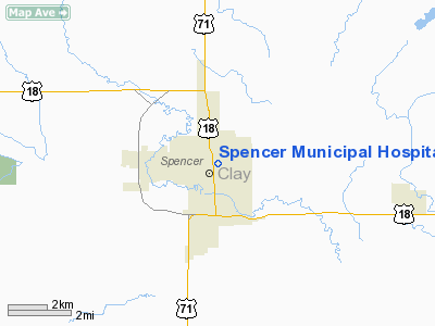
Spencer Municipal Hospital Heliport |
Location &
QuickFacts
|
FAA
Information Effective: |
2007-07-05 |
|
Airport
Identifier: |
1IA3 |
|
Airport
Status: |
Operational |
|
Longitude/Latitude: |
095-08-31.9810W/43-09-01.8860N
-95.142217/43.150524 (Estimated) |
|
Elevation: |
1318 ft / 401.73 m (Estimated) |
|
Land: |
0 acres |
|
From
nearest city: |
0 nautical miles N of Spencer, IA |
|
Location: |
Clay County, IA |
|
Magnetic Variation: |
05E (1985) |
Owner & Manager
|
Ownership: |
Publicly owned |
|
Owner: |
City Of Spencer |
|
Address: |
114 East 12th St
Spencer, IA 51301 |
|
Phone
number: |
712-264-6198 |
|
Manager: |
Dennis Slaymaker |
|
Address: |
114 East 12th St
Spencer, IA 51301 |
|
Phone number: |
712-264-6198 |
Airport Operations and Facilities
|
Airport
Use: |
Private
MEDICAL. |
|
Wind
indicator: |
No |
|
Segmented Circle: |
No |
|
Control
Tower: |
No |
|
Landing
fee charge: |
No |
|
Sectional chart: |
Omaha |
|
Region: |
ACE - Central |
|
Boundary
ARTCC: |
ZMP - Minneapolis |
|
Tie-in
FSS: |
FOD - Fort Dodge |
|
FSS on
Airport: |
No |
|
FSS
Phone: |
515-955-8114 |
|
FSS Toll
Free: |
1-800-WX-BRIEF |
|
Runway Information
Helipad H1
|
Dimension: |
60 x 60 ft / 18.3 x 18.3 m |
|
Surface: |
ASPH, |
|
|
Runway H1
|
Runway
|
|
Traffic
Pattern: |
Left |
Left |
|
Radio Navigation Aids
|
ID |
Type |
Name |
Ch |
Freq |
Var |
Dist |
|
LTU |
NDB |
Little Sioux |
|
326.00 |
05E |
1.5 nm |
|
EGQ |
NDB |
Emmetsburg |
|
410.00 |
04E |
19.3 nm |
|
PUF |
NDB |
Puff |
|
345.00 |
04E |
21.4 nm |
|
ISB |
NDB |
Sibley |
|
269.00 |
05E |
29.7 nm |
|
SHL |
NDB |
Sheldon |
|
338.00 |
05E |
30.6 nm |
|
MJQ |
NDB |
Jackson |
|
353.00 |
04E |
30.6 nm |
|
CKP |
NDB |
Pilot Rock |
|
423.00 |
05E |
31.0 nm |
|
POH |
NDB |
Pocahontas |
|
428.00 |
06E |
32.6 nm |
|
SLB |
NDB |
Storm Lake |
|
434.00 |
04E |
33.4 nm |
|
AXA |
NDB |
Algona |
|
403.00 |
03E |
38.4 nm |
|
ORC |
NDB |
Orange City |
|
521.00 |
05E |
41.4 nm |
|
MWM |
NDB |
Windom |
|
203.00 |
03E |
45.6 nm |
|
SOY |
NDB |
Sioux Center |
|
368.00 |
06E |
46.0 nm |
|
SKI |
NDB |
Sac City |
|
356.00 |
04E |
46.8 nm |
|
EST |
VOR |
Estherville |
|
110.40 |
07E |
23.3 nm |
|
SPW |
VOR/DME |
Spencer |
037X |
110.00 |
05E |
2.7 nm |
|
DDL |
VOR/DME |
Sheldon |
023X |
108.60 |
05E |
30.5 nm |
|
OTG |
VOR/DME |
Worthington |
043X |
110.60 |
08E |
35.5 nm |
|
FRM |
VOR/DME |
Fairmont |
039X |
110.20 |
07E |
43.3 nm |
|
FOD |
VORTAC |
Fort Dodge |
082X |
113.50 |
07E |
49.4 nm |
Remarks
-
OWNER DOES NOT
WANT CHARTING.
-
PROVIDED THE
APPROACH/DEPARTURE PATHS ARE MAINTAINED FOR A MINIMUM 8:1 GLIDE SLOPE AND THE
TRANSITIONAL SURFACE BE MAINTAINED FOR A 2:1 SLOPE.
Spencer Municipal Hospital Heliport
Address:
Clay County, IA
Tel:
712-264-6198
Images
and information placed above are from
http://www.airport-data.com/airport/1IA3/
We
thank them for the data!
|
General Info |
| Country |
United
States |
| State |
IOWA
|
| FAA ID |
1IA3
|
| Latitude |
43-09-01.886N |
|
Longitude |
095-08-31.981W |
|
Elevation |
1318
feet |
| Near
City |
SPENCER
|
We don't guarantee the information is fresh and accurate. The data may
be wrong or outdated.
For more up-to-date information please refer to other sources.
|
|


