|
 |
|
||||
|
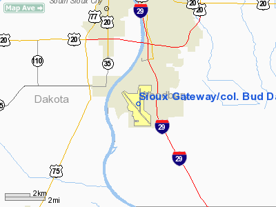
Sioux Gateway Airport (IATA: SUX, ICAO: KSUX, FAA LID: SUX), also known as Colonel Bud Day Field, is a joint civil-military public airport located 6 miles (10 km) south of Sioux City and just west of Sergeant Bluff, in Woodbury County, Iowa, United States. In addition to commercial and general aviation service, the airport is home to the 185th Air Refueling Wing (185 ARW), an Air Mobility Command (AMC)-gained unit of the Iowa Air National Guard, flying the KC-135 Stratotanker. OverviewThe airport is owned and operated by the City of Sioux City and governed by a seven member Airport Board of Trustees. Airport Board members are appointed by the City Council and serve four-year terms. Northwest Airlines just recently announced that they would open a call center for ticketing in a downtown building employing 200-300 people. Airport GrowthIn June 2007, after months of waiting, the city and the airport found out that Frontier Airlines would start service to and from Denver. The airline ended service from Sioux Gateway Airport on May 12, 2008 citing rising fuel prices. Recently, the Board of Trustees has been pursuing other airlines as well as finalizing plans to remodel the airport. Since July 2007 the airport has added an additional three arrivals and departures. In the first few months of 2008 Frontier was expected to begin another arrival and departure time, adding to total of three arrivals/departures by Frontier and five arrivals/departures by Northwest Airlines daily. Since adding a second airline, passenger numbers at the airport have increased by as low as 120 percent and as high as 210 percent in February 2008. However, Frontier ended all service from the airport in May 2008. SUX ControversyThe airport designator "SUX" has been contentious. Sioux City Mayor Craig Berenstein in 2002 described SUX as an "embarrassment" to the city. After petitioning the FAA for a changed airport identifier in 1998 and 2002, authorities found the alternatives offered - GWU, GYO, GYT, SGV and GAY - to be unappealing, and elected to stay with SUX. In October 2007, airport board member Dave Bernstein proposed embracing the identifier, saying "Let's make the best of it. I think we have the opportunity to turn it into a positive." and noting "I've got buddies that I went to college with in different cities that can't even remember their own birthdays, but they all know the Sioux City designator â SUX." The airport now sells merchandise with the words "Fly SUX". Facilities and aircraftSioux Gateway Airport covers an area of 2,460 acres (996 ha) which contains two runways: 13/31 with a concrete surface measuring 9,002 x 150 ft (2,744 x 46 m) and 17/35 with an asphalt surface measuring 6,600 x 150 ft (2,012 x 46 m). For the 12-month period ending April 30, 2006, the airport had 30,726 aircraft operations, an average of 84 per day: 65% general aviation, 19% military and 16% scheduled commercial. There are 67 aircraft based at this airport: 66% single engine, 19% jet aircraft, 13% military and 1% helicopters. Airlines and destinations
HistoryWorld War II and aftermath
The construction of Sioux City Army Air Base began in March 1942, about three months after the Japanese attack on Pearl Harbor. Opened on 5 July 1942, it became a major training center during World War II for crew members of B-24 Liberators and B-17 Flying Fortresses. The host unit at the base was the 354th Army Air Force Base Unit , and the major training organization was the 393d Combat Training School (later redesignated 224th Combat Crew Training School in 1944). At its peak, (October 1943) there were 940 officers and 5,183 enlisted men either assigned or attached to the base. The major training activities at Sioux City included aerial gunnery, bombardment, navigation, formation flying, and other related courses. During 1943, training at the field was intended to prepare an entire bomb group for overseas combat. Later, after sufficient Bomb Groups had been formed and trained, the base switched to training individual crews as replacements or additions to various bomb groups. Hollywood actor, pilot and Army Air Force Captain (later Colonel) James Stewart was posted to Sioux City with his squadron in 1943, where he and his crew completed their initial B-17 Flying Fortress qualification prior to deployment overseas. Stewart would later transition to the B-24 Liberator. The training of B-17 crews continued until May 1945. Around that time, the field received a new mission which required the conversion of the facilities for B-29 Superfortress training. The base was transferred to the 17th Bombardment Operational Training Wing and began the transition to start B-29 training. By early June, there were ten B-29's on the field. The new training program was short lived, however because in August 1945 it was canceled. With the end of World War II, the former training base switched to becoming a processing center to discharge personnel out of the service and back into civilian life. With its mission completed, Sioux City Army Air Base closed in December 1945. However, the facility would not remain closed for long, as in September 1946 the airfield was opened by the Air Force Reserve. Sioux City Air Base was one of the first Air Force Reserve bases established after the war, and in December 1946 the 185th Iowa Air National Guard unit was established at Sioux City. Assigned to the new Air Defense Command (ADC) upon reactivation, the 140th Army Air Force base unit was activated as its host unit. The mission of the 140th AFBU was to offer flight and ground training to all commissioned and enlisted members of the Air Force Reserve residing in Iowa, Minnesota, Nebraska, South Dakota and Wyoming. During the 1950s, ADC based the 521st Air Defense Group at Sioux City beginning on 15 February 1953 as part of the Central Air Defense Force. The 521st had the 14th, 87th and 519th Fighter-Interceptor Squadrons, equipped with F-86 Sabres, F-84 Thunderstreaks, and F-102 Delta Daggers. In 1955, the 521st was reassigned and replaced by the 13th Fighter-Interceptor Squadron, which flew with the 14th FIS from the base until 1960. Beginning in 1959, the ADC flying activity was reduced and Sioux City became an ADC command and control base. The 30th Air Division headquarters was reassigned to the base on 1 July, with the responsibility for the air defense of most of the midwest United States. The 30th was briefly replaced by the 31st Air Division in 1966. However, by the mid-1960s ADC was reducing its forces, and on 1 April 1966 the 31st AD was reassigned and the airport was turned over to the Air Force Reserve and Iowa Air National Guard for limited military use. AccidentsOn July 19, 1989, a United Airlines DC-10, on a flight from Denver to Philadelphia via Chicago, crashed at Sioux Gateway Airport while attempting an emergency landing. 112 passengers and 1 crew member were killed, while 184 passengers and 10 crew members survived. The accident was one of the most famous aviation disasters in American history, due to the skill of the crew in saving most of the occupants, and because the crash and rescue operation were captured on videotape by a news crew. The above content comes from Wikipedia and is published under free licenses – click here to read more.
Runway InformationRunway 13/31
Runway 17/35
Radio Navigation Aids
Remarks
Based Aircraft
Operational StatisticsTime Period: 2005-05-01 - 2006-04-30
Sioux Gateway/col. Bud Day Field Airport Address: Woodbury County, IA Tel: 712-279-6165, 712-279-0170 Images
and information placed above are from We thank them for the data!
We don't guarantee the information is fresh and accurate. The data may
be wrong or outdated.
|
||||||||||||||||||||||||||||||||||||||||||||||||||||||||||||||||||||||||||||||||||||||||||||||||||||||||||||||||||||||||||||||||||||||||||||||||||||||||||||||||||||||||||||||||||||||||||||||||||||||||||||||||||||||||||||||||||||||||||||||||||||||||||||||||||||||||||||||||||||||||||||||||||||||||||||||||||||||||||||||||||||||||||||||||||||||||||||||||||||||||||||||||||||||||||||||||||||||||||||||||||||||||||||||||||||||||||||||||||

 |
|
Copyright 2004-2024 © by Airports-Worldwide.com, Vyshenskoho st. 36, Lviv 79010, Ukraine Legal Disclaimer |