 |
|
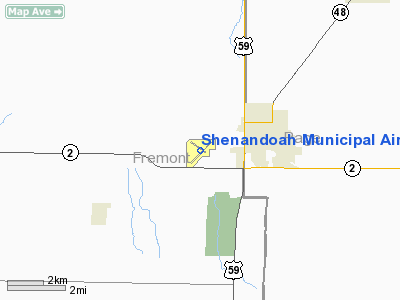
Shenandoah Municipal Airport |
|
|
Location &
QuickFacts
|
FAA
Information Effective: |
2007-07-05 |
|
Airport
Identifier: |
SDA |
|
Airport
Status: |
Operational |
|
Longitude/Latitude: |
095-24-49.2000W/40-45-05.8000N
-95.413667/40.751611 (Estimated) |
|
Elevation: |
971 ft / 295.96 m (Surveyed) |
|
Land: |
188 acres |
|
From
nearest city: |
3 nautical miles SW of Shenandoah, IA |
|
Location: |
Fremont County, IA |
|
Magnetic Variation: |
05E (1995) |
Owner & Manager
|
Ownership: |
Publicly owned |
|
Owner: |
City Of Shenandoah
BO HARRIS- CITY MGR PHONE 712-246-4411. |
|
Address: |
500 West Clarinda
Shenandoah, IA 51601 |
|
Phone
number: |
712-246-4411 |
|
Manager: |
Monica Tiemeyer |
|
Address: |
Airport Road, Po Box 2
Shenandoah, IA 51601 |
|
Phone number: |
712-246-1931 |
Airport Operations and Facilities
|
Airport
Use: |
Open to public |
|
Wind
indicator: |
Yes |
|
Segmented Circle: |
Yes |
|
Control
Tower: |
No |
|
Lighting
Schedule: |
DUSK-DAWN
ACTVT MIRL RY 04/22; VASI RYS 04, 22 & 30; REIL RYS 04 & 22 - CTAF. |
|
Beacon
Color: |
Clear-Green (lighted land airport) |
|
Landing
fee charge: |
No |
|
Sectional chart: |
Omaha |
|
Region: |
ACE - Central |
|
Boundary
ARTCC: |
ZMP - Minneapolis |
|
Tie-in
FSS: |
FOD - Fort Dodge |
|
FSS on
Airport: |
No |
|
FSS
Phone: |
515-955-8114 |
|
FSS Toll
Free: |
1-800-WX-BRIEF |
|
NOTAMs
Facility: |
SDA (NOTAM-d service avaliable) |
|
Federal Agreements: |
NGY |
Airport Communications
|
CTAF: |
122.800 |
|
Unicom: |
122.800 |
Airport Services
|
Fuel
available: |
100LLA |
|
Bottled
Oxygen: |
NONE |
|
Bulk
Oxygen: |
NONE |
|
Runway Information
Runway 04/22
|
Dimension: |
5000 x 75 ft / 1524.0 x 22.9 m |
|
Surface: |
CONC, Good Condition |
|
Weight Limit: |
Single wheel: 30000 lbs.
Dual wheel: 38000 lbs. |
|
Edge Lights: |
Medium |
|
|
Runway 04
|
Runway 22
|
|
Longitude: |
095-25-06.4109W |
095-24-21.8794W |
|
Latitude: |
40-44-43.6011N |
40-45-19.5730N |
|
Elevation: |
961.00 ft |
968.00 ft |
|
Alignment: |
43 |
127 |
|
Traffic
Pattern: |
Left |
Left |
|
Markings: |
Non-precision instrument, Fair Condition |
Non-precision instrument, Fair Condition |
|
Crossing
Height: |
25.00 ft |
25.00 ft |
|
VASI: |
2-box on left side |
2-box on left side |
|
Visual
Glide Angle: |
3.00° |
3.00° |
|
Runway End
Identifier: |
Yes |
Yes |
|
Obstruction: |
51 ft pline, 1355.0 ft from runway, 22:1 slope to clear |
24 ft pline, 900.0 ft from runway, 29:1 slope to clear |
|
Runway 12/30
|
Dimension: |
3299 x 75 ft / 1005.5 x 22.9 m |
|
Surface: |
CONC, Good Condition |
|
Weight Limit: |
Single wheel: 4000 lbs. |
|
Edge Lights: |
Low |
|
|
Runway 12
|
Runway 30
|
|
Longitude: |
095-25-14.4519W |
095-24-39.3742W |
|
Latitude: |
40-45-21.4764N |
40-45-02.7494N |
|
Elevation: |
952.00 ft |
968.00 ft |
|
Alignment: |
125 |
127 |
|
Traffic
Pattern: |
Left |
Left |
|
Markings: |
Non-precision instrument, Good Condition |
Non-precision instrument, Good Condition |
|
Crossing
Height: |
0.00 ft |
32.00 ft |
|
VASI: |
|
4-box on left side |
|
Visual
Glide Angle: |
0.00° |
3.50° |
|
Runway End
Identifier: |
|
No |
|
Obstruction: |
79 ft trees, 935.0 ft from runway, 210 ft left of
centerline, 9:1 slope to clear |
16 ft tree, 370.0 ft from runway, 110 ft left of
centerline, 10:1 slope to clear |
|
Radio Navigation Aids
|
ID |
Type |
Name |
Ch |
Freq |
Var |
Dist |
|
SDA |
NDB |
Shenandoah |
|
411.00 |
05E |
0.3 nm |
|
RDK |
NDB |
Red Oak |
|
230.00 |
04E |
17.5 nm |
|
ICL |
NDB |
Clarinda |
|
353.00 |
04E |
17.7 nm |
|
AFK |
NDB |
Nebraska City |
|
347.00 |
05E |
22.2 nm |
|
PMV |
NDB |
Plattsmouth |
|
329.00 |
06E |
25.5 nm |
|
AYB |
NDB |
Auburn |
|
430.00 |
05E |
26.1 nm |
|
EVU |
NDB |
Emville |
|
317.00 |
05E |
33.2 nm |
|
CRZ |
NDB |
Corning |
|
278.00 |
04E |
33.3 nm |
|
FNB |
NDB |
Brenner |
|
404.00 |
05E |
41.4 nm |
|
MLE |
NDB |
Millard |
|
371.00 |
06E |
41.5 nm |
|
AIO |
NDB |
Atlantic |
|
365.00 |
04E |
42.6 nm |
|
OM |
NDB |
Gerfi |
|
320.00 |
05E |
44.4 nm |
|
HNR |
NDB |
Harlan |
|
272.00 |
05E |
49.8 nm |
|
OFF |
TACAN |
Offutt |
054X |
|
05E |
31.2 nm |
|
OVR |
VORTAC |
Omaha |
110X |
116.30 |
08E |
29.0 nm |
|
PWE |
VORTAC |
Pawnee City |
071X |
112.40 |
05E |
49.1 nm |
|
OMA |
VOT |
Omaha |
|
109.00 |
|
39.1 nm |
Remarks
-
COURTESY CAR AVBL.
-
RY 22 IS CALM
WIND RY.
Based Aircraft
|
Aircraft
based on field: |
14 |
|
Single
Engine Airplanes: |
12 |
|
Ultralights: |
2 |
Operational Statistics
Time Period:
2005-05-05 -
2006-05-04
|
Aircraft
Operations: |
94/Week |
|
General
Aviation Local: |
43.2% |
|
General
Aviation Itinerant: |
56.8% |
Shenandoah Municipal Airport
Address:
Fremont County, IA
Tel:
712-246-4411,
712-246-1931
Images
and information placed above are from
http://www.airport-data.com/airport/SDA/
We
thank them for the data!
|
General Info |
| Country |
United
States |
| State |
IOWA
|
| FAA ID |
SDA
|
| Latitude |
40-45-05.334N |
|
Longitude |
095-24-48.500W |
|
Elevation |
971 feet
|
| Near
City |
SHENANDOAH |
We don't guarantee the information is fresh and accurate. The data may
be wrong or outdated.
For more up-to-date information please refer to other sources.
|
|


