 |
|
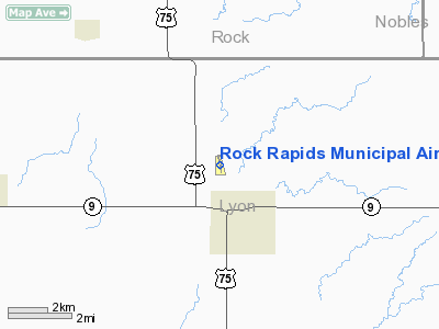
Rock Rapids Municipal Airport |
|
|
Location &
QuickFacts
|
FAA
Information Effective: |
2007-07-05 |
|
Airport
Identifier: |
RRQ |
|
Airport
Status: |
Operational |
|
Longitude/Latitude: |
096-10-47.1970W/43-27-07.9960N
-96.179777/43.452221 (Estimated) |
|
Elevation: |
1363 ft / 415.44 m (Surveyed) |
|
Land: |
40 acres |
|
From
nearest city: |
2 nautical miles NW of Rock Rapids, IA |
|
Location: |
Lyon County, IA |
|
Magnetic Variation: |
05E (2000) |
Owner & Manager
|
Ownership: |
Publicly owned |
|
Owner: |
City Of Rock Rapids |
|
Address: |
310 S 3rd Ave
Rock Rapids, IA 51246 |
|
Phone number: |
712-472-2511 |
|
Manager: |
Lyle Chapin |
|
Address: |
1357 Harding
Rock Rapids, IA 51246 |
|
Phone number: |
712-472-3332 |
Airport
Operations and Facilities
|
Airport
Use: |
Open to public |
|
Wind
indicator: |
Yes |
|
Segmented Circle: |
No |
|
Control
Tower: |
No |
|
Lighting
Schedule: |
DUSK-DAWN
ACTVT MIRL RY 16/34; PAPI RYS 16 & 34 - CTAF. |
|
Beacon
Color: |
Clear-Green (lighted land airport) |
|
Landing
fee charge: |
No |
|
Sectional chart: |
Omaha |
|
Region: |
ACE - Central |
|
Boundary
ARTCC: |
ZMP - Minneapolis |
|
Tie-in
FSS: |
FOD - Fort Dodge |
|
FSS on
Airport: |
No |
|
FSS
Phone: |
515-955-8114 |
|
FSS Toll
Free: |
1-800-WX-BRIEF |
|
NOTAMs
Facility: |
FOD (NOTAM-d service avaliable) |
|
Federal Agreements: |
Y1 |
Airport Communications
|
CTAF: |
122.800 |
|
Unicom: |
122.800 |
Airport Services
|
Fuel
available: |
100LL |
|
Airframe
Repair: |
MAJOR |
|
Power
Plant Repair: |
MAJOR |
|
Bottled
Oxygen: |
NONE |
|
Bulk
Oxygen: |
NONE |
|
Runway Information
Runway 16/34
|
Dimension: |
3097 x 50 ft / 944.0 x 15.2 m |
|
Surface: |
ASPH, Fair Condition |
|
Weight Limit: |
Single wheel: 8000 lbs. |
|
Edge Lights: |
Medium |
|
|
Runway 16
|
Runway 34
|
|
Longitude: |
096-10-50.2700W |
096-10-44.1800W |
|
Latitude: |
43-27-23.1100N |
43-26-52.8500N |
|
Elevation: |
1359.00 ft |
1357.00 ft |
|
Alignment: |
127 |
127 |
|
Traffic
Pattern: |
Left |
Left |
|
Markings: |
Non-precision instrument, Good Condition |
Non-precision instrument, Good Condition |
|
Crossing
Height: |
25.00 ft |
26.00 ft |
|
Displaced
threshold: |
300.00 ft |
300.00 ft |
|
VASI: |
2-light PAPI on left side
PAPI OTS INDEFLY. |
2-light PAPI on left side
PAPI OTS INDEFLY. |
|
Visual
Glide Angle: |
3.00° |
3.00° |
|
Obstruction: |
44 ft tree, 775.0 ft from runway, 225 ft left of
centerline, 13:1 slope to clear
CLNC 24:1 FROM DISPLACED THRESHOLD TO TREE |
, 50:1 slope to clear
APCH SLOPE 26:1 TO DSPLCD THLD FM 16 FT ROAD 430 FT FM DSPLCD THLD L/R.
+16 FT ROAD 1 30 FT DSTC L/R. |
|
Radio Navigation Aids
|
ID |
Type |
Name |
Ch |
Freq |
Var |
Dist |
|
SOY |
NDB |
Sioux Center |
|
368.00 |
06E |
19.2 nm |
|
ISB |
NDB |
Sibley |
|
269.00 |
05E |
19.3 nm |
|
SHL |
NDB |
Sheldon |
|
338.00 |
05E |
20.8 nm |
|
ORC |
NDB |
Orange City |
|
521.00 |
05E |
28.2 nm |
|
FS |
NDB |
Rokky |
|
245.00 |
06E |
28.4 nm |
|
LTU |
NDB |
Little Sioux |
|
326.00 |
05E |
49.8 nm |
|
PQN |
NDB/DME |
Pipestone |
028X |
284.00 |
06E |
32.5 nm |
|
DDL |
VOR/DME |
Sheldon |
023X |
108.60 |
05E |
20.9 nm |
|
OTG |
VOR/DME |
Worthington |
043X |
110.60 |
08E |
28.6 nm |
|
SPW |
VOR/DME |
Spencer |
037X |
110.00 |
05E |
46.2 nm |
|
FSD |
VORTAC |
Sioux Falls |
097X |
115.00 |
09E |
28.8 nm |
Remarks
Based Aircraft
|
Aircraft based
on field: |
14 |
|
Single Engine
Airplanes: |
14 |
Operational Statistics
Time Period:
2005-07-28 -
2006-07-27
|
Aircraft
Operations: |
122/Week |
|
General
Aviation Local: |
43.2% |
|
General
Aviation Itinerant: |
56.8% |
Rock Rapids Municipal
Airport
Address:
Lyon County, IA
Tel:
712-472-2511, 712-472-3332
Images
and information placed above are from
http://www.airport-data.com/airport/RRQ/
We
thank them for the data!
|
General Info |
| Country |
United
States |
| State |
IOWA
|
| FAA ID |
RRQ
|
| Latitude |
43-27-07.996N |
|
Longitude |
096-10-47.197W |
|
Elevation |
1363
feet |
| Near
City |
ROCK
RAPIDS |
We don't guarantee the information is fresh and accurate. The data may
be wrong or outdated.
For more up-to-date information please refer to other sources.
|
|


