 |
|
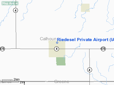
Location &
QuickFacts
|
FAA
Information Effective: |
2007-07-05 |
|
Airport
Identifier: |
IA08 |
|
Airport
Status: |
Operational |
|
Longitude/Latitude: |
094-33-06.0000W/42-16-41.0000N
-94.551667/42.278056 (Estimated) |
|
Elevation: |
1150 ft / 350.52 m (Estimated) |
|
Land: |
4 acres |
|
From
nearest city: |
1 nautical miles N of Lohrville, IA |
|
Location: |
Calhoun County, IA |
|
Magnetic Variation: |
05E (1990) |
Owner & Manager
|
Ownership: |
Privately owned |
|
Owner: |
Quentin L Riedesel |
|
Address: |
80 Elm
Lohrville, IA 51433 |
|
Phone number: |
712-465-2042 |
|
Manager: |
Quentin L Riedesel |
|
Address: |
80 Elm
Lohrville, IA 51433 |
|
Phone number: |
712-465-2042 |
Airport
Operations and Facilities
|
Airport
Use: |
Private |
|
Segmented Circle: |
No |
|
Control
Tower: |
No |
|
Sectional chart: |
Omaha |
|
Region: |
ACE - Central |
|
Boundary
ARTCC: |
ZMP - Minneapolis |
|
Tie-in
FSS: |
FOD - Fort Dodge |
|
FSS on
Airport: |
No |
|
FSS
Phone: |
515-955-8114 |
|
FSS Toll
Free: |
1-800-WX-BRIEF |
|
Runway Information
Runway 17/35
|
Dimension: |
2620 x 66 ft / 798.6 x 20.1 m |
|
Surface: |
TURF, |
|
|
Runway 17
|
Runway 35
|
|
Traffic
Pattern: |
Left |
Left |
|
Radio Navigation Aids
|
ID |
Type |
Name |
Ch |
Freq |
Var |
Dist |
|
CIN |
NDB |
Carroll |
|
397.00 |
04E |
17.4 nm |
|
EFW |
NDB |
Jefferson |
|
391.00 |
03E |
18.4 nm |
|
SKI |
NDB |
Sac City |
|
356.00 |
04E |
20.1 nm |
|
POH |
NDB |
Pocahontas |
|
428.00 |
06E |
28.5 nm |
|
EBS |
NDB |
Webster City |
|
323.00 |
03E |
31.9 nm |
|
PRO |
NDB |
Perry |
|
251.00 |
06E |
32.1 nm |
|
BNW |
NDB |
Boone |
|
407.00 |
03E |
33.9 nm |
|
GCT |
NDB |
Guthrie Center |
|
518.00 |
05E |
36.2 nm |
|
SLB |
NDB |
Storm Lake |
|
434.00 |
04E |
36.3 nm |
|
EAG |
NDB |
Eagle Grove |
|
302.00 |
03E |
38.4 nm |
|
ADU |
NDB |
Audubon |
|
266.00 |
04E |
38.8 nm |
|
DNS |
NDB |
Denison |
|
350.00 |
04E |
40.9 nm |
|
CAV |
NDB |
Clarion |
|
387.00 |
03E |
45.0 nm |
|
AXA |
NDB |
Algona |
|
403.00 |
03E |
49.8 nm |
|
EGQ |
NDB |
Emmetsburg |
|
410.00 |
04E |
49.9 nm |
|
FOD |
VORTAC |
Fort Dodge |
082X |
113.50 |
07E |
23.0 nm |
Remarks
-
PROVIDED APCHS
MAINTAINED FOR 20:1 SLOPES & TRANSITIONAL SURFACES FOR A 7:1 SLOPES.
Based
Aircraft
|
Aircraft based
on field: |
2 |
|
Single Engine
Airplanes: |
2 |
Riedesel Private Airport
Address:
Calhoun County, IA
Tel:
712-465-2042
Images
and information placed above are from
http://www.airport-data.com/airport/IA08/
We
thank them for the data!
|
General Info |
| Country |
United
States |
| State |
IOWA
|
| FAA ID |
IA08
|
| Latitude |
42-16-41.000N |
|
Longitude |
094-33-06.000W |
|
Elevation |
1150
feet |
| Near
City |
LOHRVILLE |
We don't guarantee the information is fresh and accurate. The data may
be wrong or outdated.
For more up-to-date information please refer to other sources.
|
|


