 |
|
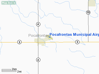
Pocahontas Municipal Airport |
|
|
Location &
QuickFacts
|
FAA
Information Effective: |
2007-07-05 |
|
Airport
Identifier: |
POH |
|
Airport
Status: |
Operational |
|
Longitude/Latitude: |
094-38-50.3000W/42-44-34.1000N
-94.647306/42.742806 (Estimated) |
|
Elevation: |
1224 ft / 373.08 m (Surveyed) |
|
Land: |
174 acres |
|
From
nearest city: |
1 nautical miles NE of Pocahontas, IA |
|
Location: |
Pocahontas County, IA |
|
Magnetic Variation: |
05E (1985) |
Owner & Manager
|
Ownership: |
Publicly owned |
|
Owner: |
City Of Pocahontas |
|
Address: |
City Hall 23 West Elm
Pocahontas, IA 50574 |
|
Phone number: |
712-335-4841 |
|
Manager: |
Gary Mc Cartan |
|
Address: |
218 North Main
Pocahontas, IA 50574 |
|
Phone number: |
712-335-4382
OFFICE NUMBER 712-335-4677 |
Airport
Operations and Facilities
|
Airport
Use: |
Open to public |
|
Wind
indicator: |
Yes |
|
Segmented Circle: |
No |
|
Control
Tower: |
No |
|
Lighting
Schedule: |
DUSK-DAWN
ACTVT MIRL RY 11/29; PAPI RY 11; VASI RY 29 & REIL RYS 11 & 29 - CTAF. |
|
Beacon
Color: |
Clear-Green (lighted land airport) |
|
Landing
fee charge: |
No |
|
Sectional chart: |
Omaha |
|
Region: |
ACE - Central |
|
Boundary
ARTCC: |
ZMP - Minneapolis |
|
Tie-in
FSS: |
FOD - Fort Dodge |
|
FSS on
Airport: |
No |
|
FSS
Phone: |
515-955-8114 |
|
FSS Toll
Free: |
1-800-WX-BRIEF |
|
NOTAMs
Facility: |
FOD (NOTAM-d service avaliable) |
|
Federal Agreements: |
N1 |
Airport Communications
|
CTAF: |
122.800 |
|
Unicom: |
122.800 |
Airport Services
|
Fuel
available: |
100LLMOGAS |
|
Airframe
Repair: |
NONE |
|
Power
Plant Repair: |
NONE |
|
Bottled
Oxygen: |
NONE |
|
Bulk
Oxygen: |
NONE |
|
Runway Information
Runway 11/29
|
Dimension: |
4100 x 60 ft / 1249.7 x 18.3 m |
|
Surface: |
CONC, Fair Condition |
|
Weight Limit: |
Single wheel: 15000 lbs. |
|
Edge Lights: |
Medium |
|
|
Runway 11
|
Runway 29
|
|
Longitude: |
094-39-16.3980W |
094-38-29.5350W |
|
Latitude: |
42-44-44.5540N |
42-44-23.4290N |
|
Elevation: |
1224.00 ft |
1221.00 ft |
|
Alignment: |
121 |
127 |
|
Traffic
Pattern: |
Left |
Left |
|
Markings: |
Non-precision instrument, Fair Condition |
Non-precision instrument, Fair Condition |
|
Crossing
Height: |
30.00 ft |
0.00 ft |
|
VASI: |
2-light PAPI on left side |
2-box on left side |
|
Visual
Glide Angle: |
3.15° |
3.00° |
|
Runway End
Identifier: |
Yes
REIL OTS INDEFLY. |
Yes
REIL OTS INDEFLY. |
|
Obstruction: |
54 ft tree, 852.0 ft from runway, 305 ft left of
centerline, 12:1 slope to clear |
15 ft road, 520.0 ft from runway, 295 ft right of
centerline, 21:1 slope to clear |
|
Runway 18/36
|
Dimension: |
1950 x 135 ft / 594.4 x 41.1 m |
|
Surface: |
TURF, Fair Condition |
|
|
Runway 18
|
Runway 36
|
|
Longitude: |
094-38-44.2980W |
094-38-46.9260W |
|
Latitude: |
42-44-45.6900N |
42-44-22.9060N |
|
Alignment: |
127 |
5 |
|
Traffic
Pattern: |
Left |
Left |
|
Obstruction: |
19 ft road, 405.0 ft from runway, 21:1 slope to clear |
, 50:1 slope to clear |
|
Radio Navigation Aids
|
ID |
Type |
Name |
Ch |
Freq |
Var |
Dist |
|
POH |
NDB |
Pocahontas |
|
428.00 |
06E |
0.2 nm |
|
EGQ |
NDB |
Emmetsburg |
|
410.00 |
04E |
21.7 nm |
|
AXA |
NDB |
Algona |
|
403.00 |
03E |
26.2 nm |
|
SKI |
NDB |
Sac City |
|
356.00 |
04E |
26.4 nm |
|
SLB |
NDB |
Storm Lake |
|
434.00 |
04E |
27.7 nm |
|
LTU |
NDB |
Little Sioux |
|
326.00 |
05E |
31.5 nm |
|
EAG |
NDB |
Eagle Grove |
|
302.00 |
03E |
32.6 nm |
|
PUF |
NDB |
Puff |
|
345.00 |
04E |
36.8 nm |
|
EBS |
NDB |
Webster City |
|
323.00 |
03E |
38.9 nm |
|
CAV |
NDB |
Clarion |
|
387.00 |
03E |
39.2 nm |
|
CKP |
NDB |
Pilot Rock |
|
423.00 |
05E |
40.0 nm |
|
CIN |
NDB |
Carroll |
|
397.00 |
04E |
42.4 nm |
|
EFW |
NDB |
Jefferson |
|
391.00 |
03E |
45.9 nm |
|
EST |
VOR |
Estherville |
|
110.40 |
07E |
40.3 nm |
|
SPW |
VOR/DME |
Spencer |
037X |
110.00 |
05E |
35.1 nm |
|
FOD |
VORTAC |
Fort Dodge |
082X |
113.50 |
07E |
17.5 nm |
Remarks
Based
Aircraft
|
Aircraft based
on field: |
21 |
|
Single Engine
Airplanes: |
20 |
|
Helicopters: |
1 |
Operational Statistics
Time Period:
2005-07-14 -
2006-07-13
|
Aircraft
Operations: |
197/Week |
|
General
Aviation Local: |
43.2% |
|
General
Aviation Itinerant: |
56.8% |
Pocahontas Municipal Airport
Address:
Pocahontas County, IA
Tel:
712-335-4841, 712-335-4382
Images
and information placed above are from
http://www.airport-data.com/airport/POH/
We
thank them for the data!
|
General Info |
| Country |
United
States |
| State |
IOWA
|
| FAA ID |
POH
|
| Latitude |
42-44-34.100N |
|
Longitude |
094-38-50.300W |
|
Elevation |
1224
feet |
| Near
City |
POCAHONTAS |
We don't guarantee the information is fresh and accurate. The data may
be wrong or outdated.
For more up-to-date information please refer to other sources.
|
|


