 |
|
|
|
|
|
Location &
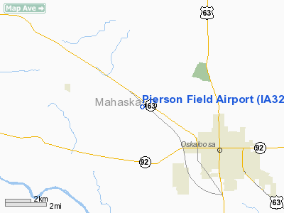
QuickFacts
|
FAA
Information Effective: |
2007-07-05 |
|
Airport
Identifier: |
IA32 |
|
Airport
Status: |
Operational |
|
Longitude/Latitude: |
092-43-01.6990W/41-19-30.0130N
-92.717139/41.325004 (Estimated) |
|
Elevation: |
845 ft / 257.56 m (Estimated) |
|
Land: |
5 acres |
|
From
nearest city: |
4 nautical miles NW of Oskaloosa, IA |
|
Location: |
Mahaska County, IA |
|
Magnetic Variation: |
03E (1985) |
Owner & Manager
|
Ownership: |
Privately owned |
|
Owner: |
Royce D. Pierson |
|
Address: |
1810 Hwy 163
Oskaloosa, IA 52577 |
|
Phone number: |
515-673-3415 |
|
Manager: |
Royce D Pierson |
|
Address: |
1810 Hwy 163
Oskaloosa, IA 52577 |
|
Phone number: |
515-673-3415 |
Airport Operations and Facilities
|
Airport Use: |
Private |
|
Wind indicator: |
Yes |
|
Segmented Circle: |
No |
|
Control Tower: |
No |
|
Landing fee charge: |
No |
|
Sectional chart: |
Chicago |
|
Region: |
ACE - Central |
|
Boundary ARTCC: |
ZAU - Chicago |
|
Tie-in FSS: |
FOD - Fort Dodge |
|
FSS on Airport: |
No |
|
FSS Phone: |
515-955-8114 |
|
FSS Toll Free: |
1-800-WX-BRIEF |
Airport Services
|
Fuel
available: |
100LL
FUEL FOR EMERG ONLY CALL 515-673-7998/3415. |
|
Airframe
Repair: |
NONE |
|
Power
Plant Repair: |
NONE |
|
Runway Information
Runway 18/36
|
Dimension: |
1800 x 75 ft / 548.6 x 22.9 m |
|
Surface: |
TURF, Fair Condition |
|
|
Runway 18
|
Runway 36
|
|
Traffic
Pattern: |
Left |
Left |
|
Obstruction: |
50 ft tree, 450.0 ft from runway, 50 ft left of
centerline, 9:1 slope to clear |
, 50:1 slope to clear |
|
Radio Navigation Aids
|
ID |
Type |
Name |
Ch |
Freq |
Var |
Dist |
|
PEA |
NDB |
Pella |
|
257.00 |
02E |
11.3 nm |
|
OOA |
NDB |
Oskaloosa |
|
414.00 |
03E |
12.0 nm |
|
OXV |
NDB |
Knoxville |
|
284.00 |
03E |
18.0 nm |
|
GGI |
NDB |
Grinnell |
|
248.00 |
02E |
23.1 nm |
|
CNC |
NDB |
Chariton |
|
335.00 |
05E |
34.6 nm |
|
BEX |
NDB |
Bloomfield |
|
269.00 |
02E |
37.2 nm |
|
FFL |
NDB |
Fairfield |
|
332.00 |
03E |
38.0 nm |
|
TZT |
NDB |
Belle Plaine |
|
371.00 |
02E |
38.9 nm |
|
TVK |
NDB |
Centerville |
|
290.00 |
04E |
39.2 nm |
|
IKV |
NDB |
Ankeny |
|
275.00 |
03E |
44.2 nm |
|
AWG |
NDB |
Washington |
|
219.00 |
02E |
47.2 nm |
|
MIW |
NDB |
Marshalltown |
|
239.00 |
03E |
48.0 nm |
|
OTM |
VOR/DME |
Ottumwa |
053X |
111.60 |
06E |
25.1 nm |
|
TNU |
VOR/DME |
Newton |
072X |
112.50 |
03E |
32.7 nm |
|
JWJ |
VOR/DME |
Elmwood |
031X |
109.40 |
03E |
48.0 nm |
|
DSM |
VORTAC |
Des Moines |
122X |
117.50 |
07E |
42.6 nm |
|
DSM |
VOT |
Des Moines |
|
109.20 |
|
45.0 nm |
Remarks
-
RY 18 HAS MKD 31
FT PLINE 800 FT NORTH.
-
PRVDD APCH TO
EACH RWY MAINTD FOR MNM 20:1 GLIDE SLOPE AND TRSNL SFC MAINTD FOR 7:1 SLOPE.
Based
Aircraft
|
Aircraft based
on field: |
2 |
|
Single Engine
Airplanes: |
2 |
Operational Statistics
Time Period:
1992-06-23 -
1993-06-22
|
Aircraft
Operations: |
14/Month |
|
General
Aviation Local: |
93.8% |
|
General
Aviation Itinerant: |
6.3% |
Pierson Field Airport
Address:
Mahaska County, IA
Tel:
515-673-3415
Images
and information placed above are from
http://www.airport-data.com/airport/IA32/
We
thank them for the data!
|
General Info |
| Country |
United
States |
| State |
IOWA
|
| FAA ID |
IA32
|
| Latitude |
41-19-30.013N |
|
Longitude |
092-43-01.699W |
|
Elevation |
845 feet
|
| Near
City |
OSKALOOSA |
We don't guarantee the information is fresh and accurate. The data may
be wrong or outdated.
For more up-to-date information please refer to other sources.
|
|


