 |
|
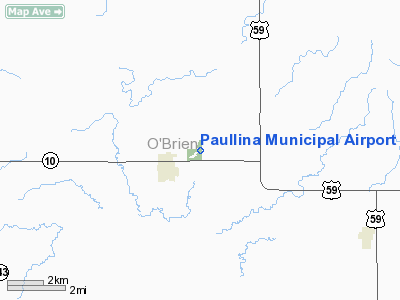
Paullina Municipal Airport |
|
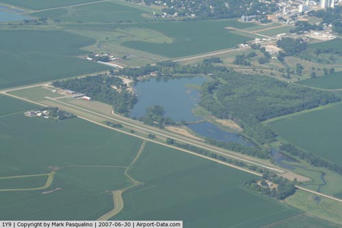 |
(Click on the photo to enlarge) |
Location &
QuickFacts
|
FAA
Information Effective: |
2007-07-05 |
|
Airport
Identifier: |
1Y9 |
|
Airport
Status: |
Operational |
|
Longitude/Latitude: |
095-39-52.0340W/42-59-17.9290N
-95.664454/42.988314 (Estimated) |
|
Elevation: |
1385 ft / 422.15 m (Estimated) |
|
Land: |
33 acres |
|
From
nearest city: |
1 nautical miles E of Paullina, IA |
|
Location: |
O Brien County, IA |
|
Magnetic Variation: |
06E (1985) |
Owner & Manager
|
Ownership: |
Publicly owned |
|
Owner: |
City Of Paullina |
|
Address: |
City Hall Po Box 239
Paullina, IA 51046 |
|
Phone number: |
712-949-3428 |
|
Manager: |
Brian Fisch |
|
Address: |
4217 Roosevelt Ave
Paullina, IA 51046 |
|
Phone number: |
712-448-2522 |
Airport
Operations and Facilities
|
Airport
Use: |
Open to public |
|
Wind
indicator: |
Yes |
|
Segmented Circle: |
No |
|
Control
Tower: |
No |
|
Lighting
Schedule: |
RDO-CTL
ACTVT LIRL RY 17/35 - CTAF. |
|
Landing
fee charge: |
No |
|
Sectional chart: |
Omaha |
|
Region: |
ACE - Central |
|
Boundary
ARTCC: |
ZMP - Minneapolis |
|
Tie-in
FSS: |
FOD - Fort Dodge |
|
FSS on
Airport: |
No |
|
FSS
Phone: |
515-955-8114 |
|
FSS Toll
Free: |
1-800-WX-BRIEF |
|
NOTAMs
Facility: |
FOD (NOTAM-d service avaliable) |
Airport Communications
Airport Services
|
Fuel
available: |
100LL
FOR FUEL CALL (712) 448-2522. |
|
Airframe
Repair: |
NONE |
|
Power
Plant Repair: |
NONE |
|
Bottled
Oxygen: |
NONE |
|
Bulk
Oxygen: |
NONE |
|
Runway Information
Runway 17/35
|
Dimension: |
2800 x 28 ft / 853.4 x 8.5 m
28 FT ASPH IN CENTER OF 120 FT WIDE TURF STRIP. |
|
Surface: |
ASPH, Fair Condition |
|
Edge Lights: |
Non-standard lighting system
NSTD LIRL; RY LGTS 60 FT FM CNTRLN. |
|
|
Runway 17
|
Runway 35
|
|
Traffic
Pattern: |
Left |
Left |
|
Markings: |
Numbers only, Fair Condition |
Numbers only, Fair Condition |
|
Displaced
threshold: |
150.00 ft
RY 17 150 FT DSPLCD THLD. |
0.00 ft |
|
Obstruction: |
32 ft tree, 246.0 ft from runway, 119 ft right of
centerline, 1:1 slope to clear
RWY 17 RY 17 APCH SLOPE 12:1 TO DSPLCD THLD. |
12 ft road, 350.0 ft from runway, 12:1 slope to clear |
|
Radio Navigation Aids
|
ID |
Type |
Name |
Ch |
Freq |
Var |
Dist |
|
SHL |
NDB |
Sheldon |
|
338.00 |
05E |
15.5 nm |
|
CKP |
NDB |
Pilot Rock |
|
423.00 |
05E |
16.2 nm |
|
ORC |
NDB |
Orange City |
|
521.00 |
05E |
17.4 nm |
|
ISB |
NDB |
Sibley |
|
269.00 |
05E |
23.1 nm |
|
SOY |
NDB |
Sioux Center |
|
368.00 |
06E |
24.7 nm |
|
LTU |
NDB |
Little Sioux |
|
326.00 |
05E |
24.8 nm |
|
SLB |
NDB |
Storm Lake |
|
434.00 |
04E |
29.8 nm |
|
EGQ |
NDB |
Emmetsburg |
|
410.00 |
04E |
42.6 nm |
|
PUF |
NDB |
Puff |
|
345.00 |
04E |
46.1 nm |
|
POH |
NDB |
Pocahontas |
|
428.00 |
06E |
47.1 nm |
|
GAK |
NDB |
Sioux Gateway |
|
233.00 |
06E |
47.2 nm |
|
SKI |
NDB |
Sac City |
|
356.00 |
04E |
47.4 nm |
|
OI |
NDB |
Tommi |
|
305.00 |
07E |
47.4 nm |
|
SU |
NDB |
Salix |
|
414.00 |
07E |
48.4 nm |
|
MEY |
NDB |
Mapleton |
|
335.00 |
05E |
48.9 nm |
|
MJQ |
NDB |
Jackson |
|
353.00 |
04E |
49.5 nm |
|
EST |
VOR |
Estherville |
|
110.40 |
07E |
47.6 nm |
|
DDL |
VOR/DME |
Sheldon |
023X |
108.60 |
05E |
15.4 nm |
|
SPW |
VOR/DME |
Spencer |
037X |
110.00 |
05E |
22.9 nm |
|
OTG |
VOR/DME |
Worthington |
043X |
110.60 |
08E |
39.8 nm |
|
SUX |
VORTAC |
Sioux City |
112X |
116.50 |
09E |
48.4 nm |
Based
Aircraft
|
Aircraft based
on field: |
7 |
|
Single Engine
Airplanes: |
7 |
Operational Statistics
Time Period:
2005-07-28 -
2006-07-27
|
Aircraft
Operations: |
66/Week |
|
General
Aviation Local: |
43.2% |
|
General
Aviation Itinerant: |
56.8% |
Paullina Municipal Airport
Address:
O Brien County, IA
Tel:
712-949-3428, 712-448-2522
Images
and information placed above are from
http://www.airport-data.com/airport/1Y9/
We
thank them for the data!
|
General Info |
| Country |
United
States |
| State |
IOWA
|
| FAA ID |
1Y9
|
| Latitude |
42-59-17.929N |
|
Longitude |
095-39-52.034W |
|
Elevation |
1385
feet |
| Near
City |
PAULLINA
|
We don't guarantee the information is fresh and accurate. The data may
be wrong or outdated.
For more up-to-date information please refer to other sources.
|
|


