 |
|
Northeast Iowa Regional Airport |
| Northeast Iowa Regional Airport |
| IATA: CCY â ICAO: KCCY â FAA LID: CCY |
| Summary |
| Airport type |
Public |
| Owner |
North Cedar Aviation Authority |
| Serves |
Charles City, Iowa |
| Elevation AMSL |
1,125 ft / 343 m |
| Coordinates |
43°04â²21â³N 092°36â²39â³W / 43.0725°N 92.61083°W / 43.0725; -92.61083 |
| Runways |
| Direction |
Length |
Surface |
| ft |
m |
| 12/30 |
4,001 |
1,220 |
Concrete |
| 4/22 |
2,536 |
773 |
Turf |
| 17/35 |
1,780 |
543 |
Turf |
| Statistics (2007) |
| Aircraft operations |
5,250 |
| Based aircraft |
24 |
| Source: Federal Aviation Administration |
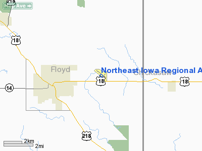
Northeast Iowa Regional Airport (IATA: CCY, ICAO: KCCY, FAA LID: CCY) is a public airport located three miles (5 km) east of the central business district of Charles City, in Floyd County, Iowa, United States. It is owned by the North Cedar Aviation Authority and was formerly known as Charles City Municipal Airport.
Facilities and aircraft
Northeast Iowa Regional Airport covers an area of 200 acres (81 ha) which contains one concrete paved runway: 12/30 measuring 4,001 x 75 ft (1,220 x 23 m). It also has two turf runways: 4/22 measuring 2,536 x 160 ft (773 x 49 m) and 17/35 measuring 1,780 x 170 ft (543 x 52 m).
For the 12-month period ending August 14, 2007, the airport had 5,250 aircraft operations, an average of 14 per day: 87% general aviation and 13% air taxi. At that time there were 24 aircraft based at this airport: 88% single-engine and 13% multi-engine.
The above content comes from Wikipedia and is published under free licenses – click here to read more.
Location &
QuickFacts
|
FAA
Information Effective: |
2007-07-05 |
|
Airport
Identifier: |
CCY |
|
Airport
Status: |
Operational |
|
Longitude/Latitude: |
092-36-38.8020W/43-04-21.3910N
-92.610778/43.072609 (Estimated) |
|
Elevation: |
1125 ft / 342.90 m (Surveyed) |
|
Land: |
200 acres |
|
From
nearest city: |
3 nautical miles E of Charles City, IA |
|
Location: |
Floyd County, IA |
|
Magnetic Variation: |
03E (1990) |
Owner & Manager
|
Ownership: |
Publicly owned |
|
Owner: |
City Of Charles City |
|
Address: |
City Hall, 105 Milwaukee Mall
Charles City, IA 50616 |
|
Phone number: |
641-257-6300 |
|
Manager: |
William R Kyle |
|
Address: |
3129 Hwy 18
Charles City, IA 50616 |
|
Phone number: |
641-228-3553 |
Airport
Operations and Facilities
|
Airport
Use: |
Open to public |
|
Wind
indicator: |
Yes |
|
Segmented Circle: |
No |
|
Control
Tower: |
No |
|
Lighting
Schedule: |
DUSK-DAWN
ACTVT MIRL RY 12/30 AND REIL RYS 12 & 30 - CTAF. |
|
Beacon
Color: |
Clear-Green (lighted land airport) |
|
Landing
fee charge: |
No |
|
Sectional chart: |
Chicago |
|
Region: |
ACE - Central |
|
Boundary
ARTCC: |
ZMP - Minneapolis |
|
Responsible ARTCC: |
ZAU - Chicago |
|
Tie-in
FSS: |
FOD - Fort Dodge |
|
FSS on
Airport: |
No |
|
FSS
Phone: |
515-955-8114 |
|
FSS Toll
Free: |
1-800-WX-BRIEF |
|
NOTAMs
Facility: |
CCY (NOTAM-d service avaliable) |
|
Federal Agreements: |
NGY |
Airport Communications
|
CTAF: |
122.800 |
|
Unicom: |
122.800 |
Airport Services
|
Fuel
available: |
100LLA |
|
Airframe
Repair: |
MAJOR |
|
Power
Plant Repair: |
MAJOR |
|
Bottled
Oxygen: |
NONE |
|
Bulk
Oxygen: |
NONE |
|
Runway Information
Runway 04/22
|
Dimension: |
2536 x 160 ft / 773.0 x 48.8 m |
|
Surface: |
TURF, Good Condition |
|
|
Runway 04
|
Runway 22
|
|
Longitude: |
092-36-43.9150W |
092-36-19.7700W |
|
Latitude: |
43-04-09.4410N |
43-04-27.1630N |
|
Alignment: |
45 |
127 |
|
Traffic
Pattern: |
Left |
Left |
|
Obstruction: |
25 ft pline, 1000.0 ft from runway, 40:1 slope to clear |
31 ft tree, 702.0 ft from runway, 65 ft right of
centerline, 22:1 slope to clear |
|
Runway 12/30
|
Dimension: |
4001 x 75 ft / 1219.5 x 22.9 m |
|
Surface: |
CONC, |
|
Weight Limit: |
Single wheel: 30000 lbs. |
|
Edge Lights: |
Medium |
|
|
Runway 12
|
Runway 30
|
|
Longitude: |
092-37-03.2390W |
092-36-19.2760W |
|
Latitude: |
43-04-37.4140N |
43-04-14.5570N |
|
Elevation: |
1116.00 ft |
1116.00 ft |
|
Alignment: |
125 |
127 |
|
ILS Type: |
LOCALIZER |
|
|
Traffic
Pattern: |
Left |
Left |
|
Markings: |
Non-precision instrument, Fair Condition |
Non-precision instrument, Fair Condition |
|
Crossing
Height: |
26.00 ft |
27.00 ft |
|
VASI: |
2-box on left side |
2-box on left side |
|
Visual
Glide Angle: |
3.00° |
3.00° |
|
Runway End
Identifier: |
Yes
OTS INDEFLY. |
Yes |
|
Obstruction: |
23 ft tree, 504.0 ft from runway, 157 ft left of
centerline, 13:1 slope to clear |
46 ft tree, 770.0 ft from runway, 215 ft left of
centerline, 12:1 slope to clear |
|
Runway 17/35
|
Dimension: |
1780 x 170 ft / 542.5 x 51.8 m |
|
Surface: |
TURF, Good Condition |
|
|
Runway 17
|
Runway 35
|
|
Longitude: |
092-36-43.4430W |
092-36-43.4410W |
|
Latitude: |
43-04-23.4780N |
43-04-06.8060N |
|
Alignment: |
127 |
127 |
|
Traffic
Pattern: |
Left |
Left |
|
Obstruction: |
10 ft road, 360.0 ft from runway, 36:1 slope to clear |
10 ft road, 300.0 ft from runway, 30:1 slope to clear |
|
Radio Navigation Aids
|
ID |
Type |
Name |
Ch |
Freq |
Var |
Dist |
|
CCY |
NDB |
Charles City |
|
375.00 |
03E |
0.3 nm |
|
IY |
NDB |
Chukk |
|
417.00 |
03E |
6.3 nm |
|
CJJ |
NDB |
Cresco |
|
293.00 |
02E |
27.4 nm |
|
HPT |
NDB |
Hampton |
|
230.00 |
03E |
34.2 nm |
|
OLZ |
NDB |
Oelwein |
|
260.00 |
02E |
36.4 nm |
|
XWY |
NDB |
West Union |
|
278.00 |
02E |
37.2 nm |
|
DEH |
NDB |
Decorah |
|
236.00 |
01E |
40.2 nm |
|
FXY |
NDB |
Forest City |
|
359.00 |
05E |
45.4 nm |
|
IFA |
NDB |
Iowa Falls |
|
368.00 |
03E |
46.0 nm |
|
IIB |
NDB |
Wapsie |
|
206.00 |
02E |
47.3 nm |
|
JAY |
VOR/DME |
Austin |
019X |
108.20 |
03E |
33.2 nm |
|
RST |
VOR/DME |
Rochester |
057X |
112.00 |
05E |
42.7 nm |
|
AEL |
VOR/DME |
Albert Lea |
035X |
109.80 |
05E |
49.4 nm |
|
MCW |
VORTAC |
Mason City |
096X |
114.90 |
06E |
31.6 nm |
|
ALO |
VORTAC |
Waterloo |
059X |
112.20 |
06E |
32.4 nm |
|
UKN |
VORTAC |
Waukon |
113X |
116.60 |
05E |
48.7 nm |
Remarks
-
SAWRS AVBL ON ARPT.
-
24 HR PHONE -
TRANSIENT PILOT LOUNGE 641-257-6330.
Based
Aircraft
|
Aircraft based
on field: |
24 |
|
Single Engine
Airplanes: |
21 |
|
Multi Engine
Airplanes: |
3 |
Operational Statistics
Time Period:
2003-09-22 -
2004-09-20
|
Aircraft
Operations: |
93/Week |
|
Air Taxi: |
13.0% |
|
General
Aviation Local: |
77.0% |
|
General
Aviation Itinerant: |
10.0% |
Northeast Iowa Regional Airport
Address:
Floyd County, IA
Tel:
641-257-6300, 641-228-3553
Images
and information placed above are from
http://www.airport-data.com/airport/CCY/
We
thank them for the data!
We don't guarantee the information is fresh and accurate. The data may
be wrong or outdated.
For more up-to-date information please refer to other sources.
|
|


