 |
|
|
|
|
|
Location &
QuickFacts
|
FAA
Information Effective: |
2007-07-05 |
|
Airport
Identifier: |
IA97 |
|
Airport
Status: |
Operational |
|
Longitude/Latitude: |
092-17-00.6670W/42-18-59.9650N
-92.283519/42.316657 (Estimated) |
|
Elevation: |
950 ft / 289.56 m (Estimated) |
|
Land: |
13 acres |
|
From
nearest city: |
4 nautical miles W of La Porte City, IA |
|
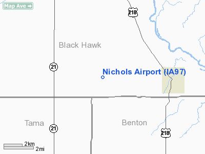
Location: |
Black Hawk County, IA |
|
Magnetic Variation: |
03E (1985) |
Owner & Manager
|
Ownership: |
Privately owned |
|
Owner: |
L. Nichols |
|
Address: |
12532 Foulk Rd.
La Porte City, IA 50651 |
|
Phone
number: |
319-342-3242 |
|
Manager: |
L. Nichols |
|
Address: |
13606 Faulk Rd
La Porte City, IA 50651 |
|
Phone number: |
319-342-3144 |
Airport Operations and Facilities
|
Airport Use: |
Private |
|
Wind indicator: |
Yes |
|
Segmented Circle: |
No |
|
Control Tower: |
No |
|
Landing fee charge: |
No |
|
Sectional chart: |
Chicago |
|
Region: |
ACE - Central |
|
Boundary ARTCC: |
ZAU - Chicago |
|
Tie-in FSS: |
FOD - Fort Dodge |
|
FSS on Airport: |
No |
|
FSS Phone: |
515-955-8114 |
|
FSS Toll Free: |
1-800-WX-BRIEF |
Airport Services
|
Fuel
available: |
100 80 |
|
Bottled
Oxygen: |
NONE |
|
Bulk
Oxygen: |
NONE |
|
Runway Information
Runway 08/26
|
Dimension: |
2120 x 80 ft / 646.2 x 24.4 m |
|
Surface: |
TURF, Good Condition |
|
|
Runway 08
|
Runway 26
|
|
Traffic
Pattern: |
Left |
Left |
|
Obstruction: |
, 50:1 slope to clear |
15 ft road, 300.0 ft from runway, 20:1 slope to clear |
|
Radio Navigation Aids
|
ID |
Type |
Name |
Ch |
Freq |
Var |
Dist |
|
VTI |
NDB |
Garrison |
|
338.00 |
03E |
13.0 nm |
|
IIB |
NDB |
Wapsie |
|
206.00 |
02E |
16.9 nm |
|
TZT |
NDB |
Belle Plaine |
|
371.00 |
02E |
25.9 nm |
|
OLZ |
NDB |
Oelwein |
|
260.00 |
02E |
25.9 nm |
|
MIW |
NDB |
Marshalltown |
|
239.00 |
03E |
30.8 nm |
|
GGI |
NDB |
Grinnell |
|
248.00 |
02E |
41.6 nm |
|
XWY |
NDB |
West Union |
|
278.00 |
02E |
43.7 nm |
|
IFA |
NDB |
Iowa Falls |
|
368.00 |
03E |
44.6 nm |
|
CCY |
NDB |
Charles City |
|
375.00 |
03E |
47.4 nm |
|
HPT |
NDB |
Hampton |
|
230.00 |
03E |
48.4 nm |
|
JWJ |
VOR/DME |
Elmwood |
031X |
109.40 |
03E |
30.5 nm |
|
CID |
VOR/DME |
Cedar Rapids |
088X |
114.10 |
05E |
34.0 nm |
|
TNU |
VOR/DME |
Newton |
072X |
112.50 |
03E |
48.8 nm |
|
ALO |
VORTAC |
Waterloo |
059X |
112.20 |
06E |
15.3 nm |
Based Aircraft
|
Aircraft based
on field: |
4 |
|
Single Engine
Airplanes: |
4 |
Operational Statistics
Time Period:
1997-07-25 -
1998-07-24
|
Aircraft
Operations: |
116/Week |
|
General
Aviation Local: |
33.3% |
|
General
Aviation Itinerant: |
66.7% |
Nichols Airport
Address:
Black Hawk County, IA
Tel:
319-342-3242,
319-342-3144
Images
and information placed above are from
http://www.airport-data.com/airport/IA97/
We
thank them for the data!
|
General Info |
| Country |
United
States |
| State |
IOWA
|
| FAA ID |
IA97
|
| Latitude |
42-18-59.965N |
|
Longitude |
092-17-00.667W |
|
Elevation |
950 feet
|
| Near
City |
LA PORTE
CITY |
We don't guarantee the information is fresh and accurate. The data may
be wrong or outdated.
For more up-to-date information please refer to other sources.
|
|


