 |
|
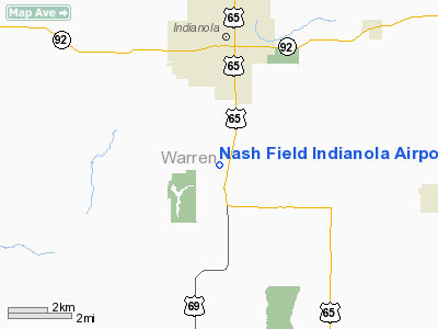
Nash Field Indianola Airport |
|
|
Location &
QuickFacts
|
FAA
Information Effective: |
2007-07-05 |
|
Airport
Identifier: |
IA66 |
|
Airport
Status: |
Operational |
|
Longitude/Latitude: |
093-34-03.7760W/41-18-13.9770N
-93.567716/41.303883 (Estimated) |
|
Elevation: |
991 ft / 302.06 m (Surveyed) |
|
Land: |
19 acres |
|
From
nearest city: |
4 nautical miles S of Indianola, IA |
|
Location: |
Warren County, IA |
|
Magnetic Variation: |
04E (1985) |
Owner & Manager
|
Ownership: |
Privately owned |
|
Owner: |
Nash Field Inc |
|
Address: |
Box 65
Indianola, IA 50125 |
|
Phone number: |
515-961-0654 |
|
Manager: |
Nash Field Inc |
|
Address: |
Box 65
Indianola, IA 50125 |
|
Phone number: |
515-961-0654 |
Airport
Operations and Facilities
|
Airport
Use: |
Private |
|
Wind
indicator: |
Yes |
|
Segmented Circle: |
No |
|
Control
Tower: |
No |
|
Lighting
Schedule: |
RDO-CTL
ACTVT LIRL RY 18/36 - 122.9. |
|
Landing fee charge: |
No |
|
Sectional chart: |
Omaha |
|
Region: |
ACE - Central |
|
Boundary ARTCC: |
ZMP - Minneapolis |
|
Tie-in FSS: |
FOD - Fort Dodge |
|
FSS on Airport: |
No |
|
FSS Phone: |
515-955-8114 |
|
FSS Toll Free: |
1-800-WX-BRIEF |
Airport Services
|
Airframe
Repair: |
NONE |
|
Power
Plant Repair: |
NONE |
|
Runway Information
Runway 18/36
|
Dimension: |
2215 x 100 ft / 675.1 x 30.5 m |
|
Surface: |
TURF, Good Condition |
|
Edge Lights: |
Non-standard lighting system
NSTD LIRL; THR LGTS RED/GREEN AT RY CORNERS AND CNTRLN. |
|
|
Runway 18
|
Runway 36
|
|
Traffic
Pattern: |
Left |
Left |
|
Displaced
threshold: |
900.00 ft |
0.00 ft |
|
Obstruction: |
10 ft road, 50.0 ft from runway, 5:1 slope to clear |
, 50:1 slope to clear
TREE OFFSET 130' LEFT OF RWY CNTRLN EXTDD. |
|
Radio Navigation Aids
|
ID |
Type |
Name |
Ch |
Freq |
Var |
Dist |
|
CNC |
NDB |
Chariton |
|
335.00 |
05E |
19.6 nm |
|
OXV |
NDB |
Knoxville |
|
284.00 |
03E |
20.5 nm |
|
IKV |
NDB |
Ankeny |
|
275.00 |
03E |
23.7 nm |
|
PEA |
NDB |
Pella |
|
257.00 |
02E |
28.8 nm |
|
GFZ |
NDB |
Greenfield |
|
338.00 |
04E |
39.6 nm |
|
UNE |
NDB |
Union County |
|
379.00 |
04E |
41.0 nm |
|
PRO |
NDB |
Perry |
|
251.00 |
06E |
41.4 nm |
|
GGI |
NDB |
Grinnell |
|
248.00 |
02E |
44.9 nm |
|
GCT |
NDB |
Guthrie Center |
|
518.00 |
05E |
45.1 nm |
|
BNW |
NDB |
Boone |
|
407.00 |
03E |
46.9 nm |
|
TVK |
NDB |
Centerville |
|
290.00 |
04E |
47.9 nm |
|
OOA |
NDB |
Oskaloosa |
|
414.00 |
03E |
49.0 nm |
|
TNU |
VOR/DME |
Newton |
072X |
112.50 |
03E |
35.5 nm |
|
DSM |
VORTAC |
Des Moines |
122X |
117.50 |
07E |
8.8 nm |
|
LMN |
VORTAC |
Lamoni |
114X |
116.70 |
07E |
46.2 nm |
|
DSM |
VOT |
Des Moines |
|
109.20 |
|
14.9 nm |
Remarks
-
TOUCH AND GO
LANDINGS WITH PRIOR PERMISSION ONLY.
Based
Aircraft
|
Aircraft based
on field: |
17 |
|
Single Engine
Airplanes: |
13 |
|
Helicopters: |
1 |
|
Ultralights: |
3 |
Operational Statistics
Time Period: 1992-06-24 - 1993-06-23
|
Aircraft
Operations: |
68/Week |
|
General
Aviation Local: |
88.6% |
|
General
Aviation Itinerant: |
11.4% |
Nash Field Indianola Airport
Address:
Warren County, IA
Tel:
515-961-0654
Images
and information placed above are from
http://www.airport-data.com/airport/IA66/
We
thank them for the data!
|
General Info |
| Country |
United
States |
| State |
IOWA
|
| FAA ID |
IA66
|
| Latitude |
41-18-13.977N |
|
Longitude |
093-34-03.776W |
|
Elevation |
991 feet
|
| Near
City |
INDIANOLA |
We don't guarantee the information is fresh and accurate. The data may
be wrong or outdated.
For more up-to-date information please refer to other sources.
|
|


