 |
|
|
|
|
|
Location &
QuickFacts
|
FAA
Information Effective: |
2007-07-05 |
|
Airport
Identifier: |
7C3 |
|
Airport
Status: |
Operational |
|
Longitude/Latitude: |
091-20-45.4870W/43-01-49.9410N
-91.345969/43.030539 (Estimated) |
|
Elevation: |
1147 ft / 349.61 m (Surveyed) |
|
Land: |
23 acres |
|
From
nearest city: |
3 nautical miles SE of Monona, IA |
|
Location: |
Clayton County, IA |
|
Magnetic Variation: |
02E (1985) |
Owner & Manager
|
Ownership: |
Publicly owned |
|
Owner: |
City Of Monona |
|
Address: |
City Hall 106 N. Page
Monona, IA 52159 |
|
Phone number: |
563-539-2355 |
|
Manager: |
Jackson Turner |
|
Address: |
Box 522
Monona, IA 52159 |
|
Phone number: |
563-539-2769 |
Airport
Operations and Facilities
|
Airport
Use: |
Open to public |
|
Wind
indicator: |
Yes |
|
Segmented Circle: |
No |
|
Control
Tower: |
No |
|
Lighting
Schedule: |
DUSK-DAWN |
|
Landing
fee charge: |
No |
|
Sectional chart: |
Chicago |
|
Region: |
ACE - Central |
|
Boundary
ARTCC: |
ZAU - Chicago |
|
Tie-in
FSS: |
FOD - Fort Dodge |
|
FSS on
Airport: |
No |
|
FSS
Phone: |
515-955-8114 |
|
FSS Toll
Free: |
1-800-WX-BRIEF |
|
NOTAMs
Facility: |
FOD (NOTAM-d service avaliable) |
Airport Communications
Airport Services
|
Fuel
available: |
100LLMOGAS
FOR FUEL CALL (563) 539-2769/2355. |
|
Airframe
Repair: |
NONE |
|
Power
Plant Repair: |
NONE |
|
Bottled
Oxygen: |
NONE |
|
Bulk
Oxygen: |
NONE |
|
Runway Information
Runway 18/36
|
Dimension: |
2650 x 120 ft / 807.7 x 36.6 m |
|
Surface: |
TURF, Good Condition |
|
Edge Lights: |
Low |
|
|
Runway 18
|
Runway 36
|
|
Elevation: |
1147.00 ft |
1016.00 ft |
|
Traffic
Pattern: |
Left |
Left |
|
Obstruction: |
13 ft road, 260.0 ft from runway, 20:1 slope to clear
ROAD 5' BELOW RWY ELEVATION. |
, 50:1 slope to clear |
|
Radio Navigation Aids
|
ID |
Type |
Name |
Ch |
Freq |
Var |
Dist |
|
XWY |
NDB |
West Union |
|
278.00 |
02E |
19.9 nm |
|
DEH |
NDB |
Decorah |
|
236.00 |
01E |
22.6 nm |
|
CHU |
NDB |
Caledonia |
|
209.00 |
03E |
34.0 nm |
|
OLZ |
NDB |
Oelwein |
|
260.00 |
02E |
34.7 nm |
|
CJJ |
NDB |
Cresco |
|
293.00 |
02E |
39.9 nm |
|
IIB |
NDB |
Wapsie |
|
206.00 |
02E |
43.8 nm |
|
PVB |
NDB |
Platteville |
|
203.00 |
01E |
45.0 nm |
|
MRJ |
NDB |
Mineral Point |
|
365.00 |
00W |
50.0 nm |
|
UKN |
VORTAC |
Waukon |
113X |
116.60 |
05E |
17.2 nm |
|
DBQ |
VORTAC |
Dubuque |
105X |
115.80 |
04E |
47.1 nm |
Remarks
-
FOR SNOW REMOVAL
DURING WINTER MONTHS CALL (563) 539-2355/2769 OR (563) 536-2851.
Based
Aircraft
|
Aircraft based
on field: |
6 |
|
Single Engine
Airplanes: |
5 |
|
Ultralights: |
1 |
Operational Statistics
Time Period:
2004-08-19 -
2005-08-18
|
Aircraft
Operations: |
33/Week |
|
General
Aviation Local: |
58.8% |
|
General
Aviation Itinerant: |
41.2% |
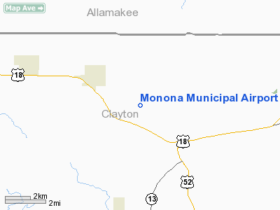
Monona Municipal Airport
Address:
Clayton County, IA
Tel:
563-539-2355, 563-539-2769
Images
and information placed above are from
http://www.airport-data.com/airport/7C3/
We
thank them for the data!
|
General Info |
| Country |
United
States |
| State |
IOWA
|
| FAA ID |
7C3
|
| Latitude |
43-01-49.941N |
|
Longitude |
091-20-45.487W |
|
Elevation |
1147
feet |
| Near
City |
MONONA
|
We don't guarantee the information is fresh and accurate. The data may
be wrong or outdated.
For more up-to-date information please refer to other sources.
|
|


