 |
|
|
|
Location &
QuickFacts
|
FAA
Information Effective: |
2007-07-05 |
|
Airport
Identifier: |
90IA |
|
Airport
Status: |
Operational |
|
Longitude/Latitude: |
095-53-16.0370W/41-32-24.9720N
-95.887788/41.540270 (Estimated) |
|
Elevation: |
1000 ft / 304.80 m (Surveyed) |
|
Land: |
70 acres |
|
From
nearest city: |
1 nautical miles S of Missouri Valley, IA |
|
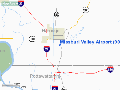
Location: |
Harrison County, IA |
|
Magnetic Variation: |
06E (1985) |
Owner & Manager
|
Ownership: |
Publicly owned |
|
Owner: |
City Of Missouri Valley Ia |
|
Address: |
Missouri Valley, IA 51555 |
|
Phone
number: |
712-642-3502 |
|
Manager: |
Steve Smith |
|
Address: |
2485 Liberty Ave
Missouri Valley, IA 51555 |
|
Phone number: |
712-642-2890 |
Airport Operations and Facilities
|
Airport Use: |
Private |
|
Wind indicator: |
Yes |
|
Segmented Circle: |
No |
|
Control Tower: |
No |
|
Landing fee charge: |
No |
|
Sectional chart: |
Omaha |
|
Region: |
ACE - Central |
|
Boundary ARTCC: |
ZMP - Minneapolis |
|
Tie-in FSS: |
FOD - Fort Dodge |
|
FSS on Airport: |
No |
|
FSS Phone: |
515-955-8114 |
|
FSS Toll Free: |
1-800-WX-BRIEF |
Airport Services
|
Airframe
Repair: |
NONE |
|
Power
Plant Repair: |
NONE |
|
Runway Information
Runway 16/34
|
Dimension: |
2400 x 25 ft / 731.5 x 7.6 m |
|
Surface: |
ASPH, Poor Condition
TAXIWAYS ROUGH; LOOSE ROCKS ON ALL AREAS. |
|
|
Runway 16
|
Runway 34
|
|
Traffic
Pattern: |
Left |
Left |
|
Obstruction: |
60 ft tree, 2100.0 ft from runway, 31:1 slope to clear |
, 50:1 slope to clear |
|
Radio Navigation Aids
|
ID |
Type |
Name |
Ch |
Freq |
Var |
Dist |
|
OM |
NDB |
Gerfi |
|
320.00 |
05E |
10.9 nm |
|
MLE |
NDB |
Millard |
|
371.00 |
06E |
23.1 nm |
|
HNR |
NDB |
Harlan |
|
272.00 |
05E |
24.7 nm |
|
FET |
NDB |
Fremont |
|
311.00 |
06E |
28.9 nm |
|
DNS |
NDB |
Denison |
|
350.00 |
04E |
35.1 nm |
|
PMV |
NDB |
Plattsmouth |
|
329.00 |
06E |
35.9 nm |
|
AHQ |
NDB |
Wahoo |
|
400.00 |
07E |
36.8 nm |
|
MEY |
NDB |
Mapleton |
|
335.00 |
05E |
38.7 nm |
|
AIO |
NDB |
Atlantic |
|
365.00 |
04E |
38.8 nm |
|
RDK |
NDB |
Red Oak |
|
230.00 |
04E |
42.6 nm |
|
ADU |
NDB |
Audubon |
|
266.00 |
04E |
44.9 nm |
|
OFF |
TACAN |
Offutt |
054X |
|
05E |
25.4 nm |
|
TQE |
VOR |
Tekamah |
|
108.40 |
07E |
18.6 nm |
|
SCB |
VOR/DME |
Scribner |
47X |
111.00 |
06E |
33.5 nm |
|
OVR |
VORTAC |
Omaha |
110X |
116.30 |
08E |
23.4 nm |
|
OMA |
VOT |
Omaha |
|
109.00 |
|
14.7 nm |
Remarks
-
200' RIDGE ONE
MILE SOUTH OF RWY.
-
BE ALERT FOR
ULTRALIGHT ACTIVITY ON & INVOF ARPT.
-
EXISTED PRIOR TO 1959.
Based Aircraft
|
Aircraft based
on field: |
15 |
|
Single Engine
Airplanes: |
8 |
|
Ultralights: |
7 |
Operational Statistics
Time Period:
1992-01-27 -
1993-01-25
|
Aircraft
Operations: |
29/Week |
|
General
Aviation Local: |
50.0% |
|
General
Aviation Itinerant: |
50.0% |
Missouri Valley Airport
Address:
Harrison County, IA
Tel:
712-642-3502,
712-642-2890
Images
and information placed above are from
http://www.airport-data.com/airport/90IA/
We
thank them for the data!
|
General Info |
| Country |
United
States |
| State |
IOWA
|
| FAA ID |
90IA
|
| Latitude |
41-32-24.972N |
|
Longitude |
095-53-16.037W |
|
Elevation |
1000
feet |
| Near
City |
MISSOURI
VALLEY |
We don't guarantee the information is fresh and accurate. The data may
be wrong or outdated.
For more up-to-date information please refer to other sources.
|
|


