 |
|
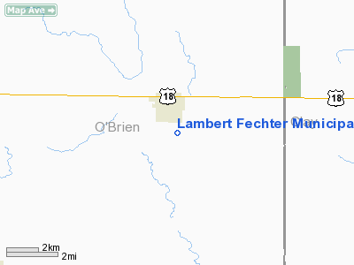
Lambert Fechter Municipal Airport |
|
|
Location &
QuickFacts
|
FAA
Information Effective: |
2007-07-05 |
|
Airport
Identifier: |
0Y4 |
|
Airport
Status: |
Operational |
|
Longitude/Latitude: |
095-28-12.0300W/43-09-51.0700N
-95.470008/43.164186 (Estimated) |
|
Elevation: |
1452 ft / 442.57 m (Estimated) |
|
Land: |
80 acres |
|
From
nearest city: |
1 nautical miles SE of Hartley, IA |
|
Location: |
O Brien County, IA |
|
Magnetic Variation: |
05E (1985) |
Owner & Manager
|
Ownership: |
Publicly owned |
|
Owner: |
City Of Hartley |
|
Address: |
11 S Central Ave
Hartley, IA 51346 |
|
Phone
number: |
712-928-2240 |
|
Manager: |
Michael Boeve |
|
Address: |
11 S Central Ave
Hartley, IA 51346 |
|
Phone number: |
712-928-2240 |
Airport Operations and Facilities
|
Airport
Use: |
Open to public |
|
Wind
indicator: |
Yes |
|
Segmented Circle: |
No |
|
Control
Tower: |
No |
|
Landing
fee charge: |
No |
|
Sectional chart: |
Omaha |
|
Region: |
ACE - Central |
|
Boundary
ARTCC: |
ZMP - Minneapolis |
|
Tie-in
FSS: |
FOD - Fort Dodge |
|
FSS on
Airport: |
No |
|
FSS
Phone: |
515-955-8114 |
|
FSS Toll
Free: |
1-800-WX-BRIEF |
|
NOTAMs
Facility: |
FOD (NOTAM-d service avaliable) |
Airport Communications
Airport Services
|
Airframe
Repair: |
NONE |
|
Power
Plant Repair: |
NONE |
|
Bottled
Oxygen: |
NONE |
|
Bulk
Oxygen: |
NONE |
|
Runway Information
Runway 17/35
|
Dimension: |
2500 x 90 ft / 762.0 x 27.4 m |
|
Surface: |
ASPH-TURF, Poor Condition
30 FT ASPH INSIDE 90 FT WIDE TURF STRIP RUNNING FULL LENGTH OF RY. |
|
|
Runway 17
|
Runway 35
|
|
Longitude: |
095-28-12.3200W |
095-28-11.7300W |
|
Latitude: |
43-10-03.4200N |
43-09-38.7300N |
|
Traffic
Pattern: |
Left |
Left |
|
Obstruction: |
, 50:1 slope to clear |
42 ft pline, 1480.0 ft from runway, 30:1 slope to clear |
|
Radio Navigation Aids
|
ID |
Type |
Name |
Ch |
Freq |
Var |
Dist |
|
LTU |
NDB |
Little Sioux |
|
326.00 |
05E |
15.0 nm |
|
SHL |
NDB |
Sheldon |
|
338.00 |
05E |
16.2 nm |
|
ISB |
NDB |
Sibley |
|
269.00 |
05E |
17.4 nm |
|
CKP |
NDB |
Pilot Rock |
|
423.00 |
05E |
26.2 nm |
|
ORC |
NDB |
Orange City |
|
521.00 |
05E |
27.9 nm |
|
SOY |
NDB |
Sioux Center |
|
368.00 |
06E |
31.6 nm |
|
EGQ |
NDB |
Emmetsburg |
|
410.00 |
04E |
33.7 nm |
|
PUF |
NDB |
Puff |
|
345.00 |
04E |
34.0 nm |
|
SLB |
NDB |
Storm Lake |
|
434.00 |
04E |
35.3 nm |
|
MJQ |
NDB |
Jackson |
|
353.00 |
04E |
35.9 nm |
|
POH |
NDB |
Pocahontas |
|
428.00 |
06E |
44.0 nm |
|
MWM |
NDB |
Windom |
|
203.00 |
03E |
47.5 nm |
|
EST |
VOR |
Estherville |
|
110.40 |
07E |
35.0 nm |
|
SPW |
VOR/DME |
Spencer |
037X |
110.00 |
05E |
11.8 nm |
|
DDL |
VOR/DME |
Sheldon |
023X |
108.60 |
05E |
16.2 nm |
|
OTG |
VOR/DME |
Worthington |
043X |
110.60 |
08E |
29.4 nm |
Remarks
-
RY 17 HAS +185 FT
TWR-GRAIN ELEVATOR 3225 FT FROM THR 485 FT R.
-
ARPT CLSD SS-SR.
-
ESTAB PRIOR TO 1959.
Based Aircraft
|
Aircraft based
on field: |
2 |
|
Single Engine
Airplanes: |
2 |
Operational Statistics
Time Period:
2004-09-28 -
2005-09-27
|
Aircraft
Operations: |
11/Week |
|
General
Aviation Local: |
54.5% |
|
General
Aviation Itinerant: |
45.5% |
Lambert Fechter Municipal Airport
Address:
O Brien County, IA
Tel:
712-928-2240
Images
and information placed above are from
http://www.airport-data.com/airport/0Y4/
We
thank them for the data!
|
General Info |
| Country |
United
States |
| State |
IOWA
|
| FAA ID |
0Y4
|
| Latitude |
43-09-44.902N |
|
Longitude |
095-28-01.022W |
|
Elevation |
1452
feet |
| Near
City |
HARTLEY
|
We don't guarantee the information is fresh and accurate. The data may
be wrong or outdated.
For more up-to-date information please refer to other sources.
|
|


