 |
|
|
|
|
|
Location &
QuickFacts
|
FAA
Information Effective: |
2007-07-05 |
|
Airport
Identifier: |
IA83 |
|
Airport
Status: |
Operational |
|
Longitude/Latitude: |
094-10-03.8570W/42-57-13.8860N
-94.167738/42.953857 (Estimated) |
|
Elevation: |
1153 ft / 351.43 m (Surveyed) |
|
Land: |
0 acres |
|
From
nearest city: |
5 nautical miles N of Livermore, IA |
|
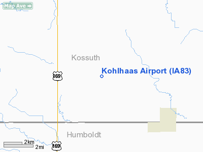
Location: |
Kossuth County, IA |
|
Magnetic Variation: |
04E (1985) |
Owner & Manager
|
Ownership: |
Privately owned |
|
Owner: |
Richard N Kohlhaas |
|
Address: |
1306 150th Ave.
Livermore, IA 50558-8509 |
|
Phone number: |
515-379-1817 |
|
Manager: |
Richard N Kohlhaas |
|
Address: |
1306 150th Ave.
Livermore, IA 50558-8509 |
|
Phone number: |
515-379-1817 |
Airport
Operations and Facilities
|
Airport
Use: |
Private |
|
Wind
indicator: |
Yes |
|
Segmented Circle: |
No |
|
Control
Tower: |
No |
|
Lighting
Schedule: |
PHONE REQ
FOR LIRL RWY 17/35 PPR CALL - 515-379-1817. |
|
Landing fee charge: |
No |
|
Sectional chart: |
Omaha |
|
Region: |
ACE - Central |
|
Boundary ARTCC: |
ZMP - Minneapolis |
|
Tie-in FSS: |
FOD - Fort Dodge |
|
FSS on Airport: |
No |
|
FSS Phone: |
515-955-8114 |
|
FSS Toll Free: |
1-800-WX-BRIEF |
Airport Services
|
Fuel
available: |
100 |
|
Airframe
Repair: |
NONE |
|
Runway Information
Runway 17/35
|
Dimension: |
2590 x 80 ft / 789.4 x 24.4 m |
|
Surface: |
TURF, |
|
Edge Lights: |
Low |
|
|
Runway 17
|
Runway 35
|
|
Traffic
Pattern: |
Left |
Left |
|
Radio Navigation Aids
|
ID |
Type |
Name |
Ch |
Freq |
Var |
Dist |
|
AXA |
NDB |
Algona |
|
403.00 |
03E |
8.9 nm |
|
EAG |
NDB |
Eagle Grove |
|
302.00 |
03E |
18.6 nm |
|
CAV |
NDB |
Clarion |
|
387.00 |
03E |
21.9 nm |
|
POH |
NDB |
Pocahontas |
|
428.00 |
06E |
24.5 nm |
|
EGQ |
NDB |
Emmetsburg |
|
410.00 |
04E |
25.3 nm |
|
FXY |
NDB |
Forest City |
|
359.00 |
05E |
29.4 nm |
|
EBS |
NDB |
Webster City |
|
323.00 |
03E |
33.5 nm |
|
PUF |
NDB |
Puff |
|
345.00 |
04E |
34.6 nm |
|
SBU |
NDB |
Blue Earth |
|
332.00 |
04E |
38.8 nm |
|
LTU |
NDB |
Little Sioux |
|
326.00 |
05E |
43.7 nm |
|
HPT |
NDB |
Hampton |
|
230.00 |
03E |
43.8 nm |
|
IFA |
NDB |
Iowa Falls |
|
368.00 |
03E |
49.1 nm |
|
SKI |
NDB |
Sac City |
|
356.00 |
04E |
49.8 nm |
|
EST |
VOR |
Estherville |
|
110.40 |
07E |
37.3 nm |
|
FRM |
VOR/DME |
Fairmont |
039X |
110.20 |
07E |
43.1 nm |
|
SPW |
VOR/DME |
Spencer |
037X |
110.00 |
05E |
47.1 nm |
|
FOD |
VORTAC |
Fort Dodge |
082X |
113.50 |
07E |
21.3 nm |
|
MCW |
VORTAC |
Mason City |
096X |
114.90 |
06E |
37.8 nm |
Remarks
-
E111:PRVDD THAT
THE APCH TO EACH RWY IS MNTND FOR A MNM 20:1 GLIDE SLOPE & THAT THE ARPT
TRANSITIONAL SURFACE BE MNTND FOR A MNM 7:1 SLOPE.
Based
Aircraft
|
Aircraft based
on field: |
3 |
|
Single Engine
Airplanes: |
3 |
Kohlhaas Airport
Address:
Kossuth County, IA
Tel:
515-379-1817
Images
and information placed above are from
http://www.airport-data.com/airport/IA83/
We
thank them for the data!
|
General Info |
| Country |
United
States |
| State |
IOWA
|
| FAA ID |
IA83
|
| Latitude |
42-57-13.886N |
|
Longitude |
094-10-03.857W |
|
Elevation |
1153
feet |
| Near
City |
LIVERMORE |
We don't guarantee the information is fresh and accurate. The data may
be wrong or outdated.
For more up-to-date information please refer to other sources.
|
|


