 |
|
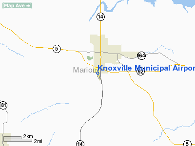
Knoxville Municipal Airport |
|
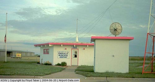 |
(Click on the photo to enlarge) |
|
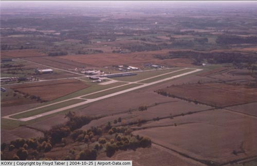 |
(Click on the photo to enlarge) |
|
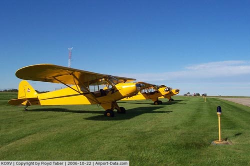 |
(Click on the photo to enlarge) |
Location &
QuickFacts
|
FAA
Information Effective: |
2007-07-05 |
|
Airport
Identifier: |
OXV |
|
Airport
Status: |
Operational |
|
Longitude/Latitude: |
093-06-49.7360W/41-17-55.9880N
-93.113816/41.298886 (Estimated) |
|
Elevation: |
928 ft / 282.85 m (Surveyed) |
|
Land: |
161 acres |
|
From
nearest city: |
2 nautical miles S of Knoxville, IA |
|
Location: |
Marion County, IA |
|
Magnetic Variation: |
02E (2000) |
Owner & Manager
|
Ownership: |
Publicly owned |
|
Owner: |
City Of Knoxville |
|
Address: |
305 South 3rd
Knoxville, IA 50138 |
|
Phone number: |
641-842-3147 |
|
Manager: |
Dan Van Donselaar |
|
Address: |
1545 Hwy 14 South
Knoxville, IA 50138 |
|
Phone number: |
641-842-4423 |
Airport
Operations and Facilities
|
Airport
Use: |
Open to public |
|
Wind
indicator: |
Yes |
|
Segmented Circle: |
No |
|
Control
Tower: |
No |
|
Lighting
Schedule: |
DUSK-DAWN
ACTVT MIRL RY 15/33 AND PAPI RYS 15 & 33 AND REIL RYS 15 & 33 - CTAF. |
|
Beacon
Color: |
Clear-Green (lighted land airport) |
|
Landing
fee charge: |
No |
|
Sectional chart: |
Omaha |
|
Region: |
ACE - Central |
|
Boundary
ARTCC: |
ZAU - Chicago |
|
Responsible ARTCC: |
ZMP - Minneapolis |
|
Tie-in
FSS: |
FOD - Fort Dodge |
|
FSS on
Airport: |
No |
|
FSS
Phone: |
515-955-8114 |
|
FSS Toll
Free: |
1-800-WX-BRIEF |
|
NOTAMs
Facility: |
OXV (NOTAM-d service avaliable) |
|
Federal Agreements: |
NGY |
Airport Communications
|
CTAF: |
122.800 |
|
Unicom: |
122.800 |
Airport Services
|
Fuel
available: |
100LLA |
|
Airframe
Repair: |
MAJOR |
|
Power
Plant Repair: |
MAJOR |
|
Bottled
Oxygen: |
NONE |
|
Bulk
Oxygen: |
NONE |
|
Runway Information
Runway 15/33
|
Dimension: |
4000 x 75 ft / 1219.2 x 22.9 m |
|
Surface: |
ASPH-CONC, Good Condition |
|
Weight Limit: |
Single wheel: 28000 lbs.
Dual wheel: 48000 lbs. |
|
Edge Lights: |
Medium |
|
|
Runway 15
|
Runway 33
|
|
Longitude: |
093-07-00.2040W |
093-06-38.7657W |
|
Latitude: |
41-18-14.7940N |
41-17-38.7336N |
|
Elevation: |
924.00 ft |
928.00 ft |
|
Alignment: |
127 |
127 |
|
Traffic
Pattern: |
Left |
Left |
|
Markings: |
Non-precision instrument, Good Condition |
Non-precision instrument, Good Condition |
|
Crossing
Height: |
28.00 ft |
27.00 ft |
|
VASI: |
2-light PAPI on left side |
2-light PAPI on left side |
|
Visual
Glide Angle: |
3.00° |
3.00° |
|
Runway End
Identifier: |
Yes |
Yes |
|
Obstruction: |
31 ft pole, 825.0 ft from runway, 330 ft left of
centerline, 20:1 slope to clear |
21 ft pole, 805.0 ft from runway, 225 ft right of
centerline, 28:1 slope to clear |
|
Radio Navigation Aids
|
ID |
Type |
Name |
Ch |
Freq |
Var |
Dist |
|
OXV |
NDB |
Knoxville |
|
284.00 |
03E |
0.2 nm |
|
PEA |
NDB |
Pella |
|
257.00 |
02E |
10.0 nm |
|
CNC |
NDB |
Chariton |
|
335.00 |
05E |
20.3 nm |
|
OOA |
NDB |
Oskaloosa |
|
414.00 |
03E |
28.6 nm |
|
GGI |
NDB |
Grinnell |
|
248.00 |
02E |
30.1 nm |
|
IKV |
NDB |
Ankeny |
|
275.00 |
03E |
31.4 nm |
|
TVK |
NDB |
Centerville |
|
290.00 |
04E |
38.0 nm |
|
BEX |
NDB |
Bloomfield |
|
269.00 |
02E |
45.5 nm |
|
MIW |
NDB |
Marshalltown |
|
239.00 |
03E |
49.5 nm |
|
TNU |
VOR/DME |
Newton |
072X |
112.50 |
03E |
29.1 nm |
|
OTM |
VOR/DME |
Ottumwa |
053X |
111.60 |
06E |
39.2 nm |
|
JWJ |
VOR/DME |
Elmwood |
031X |
109.40 |
03E |
49.7 nm |
|
DSM |
VORTAC |
Des Moines |
122X |
117.50 |
07E |
25.5 nm |
|
DSM |
VOT |
Des Moines |
|
109.20 |
|
29.1 nm |
Based Aircraft
|
Aircraft based
on field: |
36 |
|
Single Engine
Airplanes: |
30 |
|
Ultralights: |
6 |
Operational Statistics
Time Period:
2004-11-15 -
2005-11-14
|
Aircraft
Operations: |
187/Week |
|
Air Taxi: |
1.0% |
|
General
Aviation Local: |
51.5% |
|
General
Aviation Itinerant: |
46.4% |
|
Military: |
1.0% |
Knoxville Municipal Airport
Address:
Marion County, IA
Tel:
641-842-3147, 641-842-4423
Images
and information placed above are from
http://www.airport-data.com/airport/OXV/
We
thank them for the data!
|
General Info |
| Country |
United
States |
| State |
IOWA
|
| FAA ID |
OXV
|
| Latitude |
41-17-55.988N |
|
Longitude |
093-06-49.736W |
|
Elevation |
928 feet
|
| Near
City |
KNOXVILLE |
We don't guarantee the information is fresh and accurate. The data may
be wrong or outdated.
For more up-to-date information please refer to other sources.
|
|


