 |
|
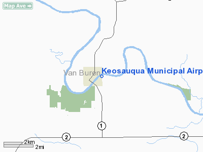
Keosauqua Municipal Airport |
|
|
Location &
QuickFacts
|
FAA
Information Effective: |
2007-07-05 |
|
Airport
Identifier: |
6K9 |
|
Airport
Status: |
Operational |
|
Longitude/Latitude: |
091-56-55.6190W/40-44-05.1000N
-91.948783/40.734750 (Estimated) |
|
Elevation: |
580 ft / 176.78 m (Estimated) |
|
Land: |
28 acres |
|
From
nearest city: |
1 nautical miles E of Keosauqua, IA |
|
Location: |
Van Buren County, IA |
|
Magnetic Variation: |
03E (1985) |
Owner & Manager
|
Ownership: |
Publicly owned |
|
Owner: |
City Of Keosauqua |
|
Address: |
Po Box 555
Keosauqua, IA 52565 |
|
Phone
number: |
319-293-3536 |
|
Manager: |
Jim Chambers
PUBLIC WORKS DEPT, NOT AT FIELD. |
|
Address: |
Po Box 555
Keosauqua, IA 52565 |
|
Phone number: |
319-293-3536 |
Airport
Operations and Facilities
|
Airport
Use: |
Open to public |
|
Wind
indicator: |
Yes |
|
Segmented Circle: |
No |
|
Control
Tower: |
No |
|
Landing
fee charge: |
No |
|
Sectional chart: |
Chicago |
|
Region: |
ACE - Central |
|
Boundary
ARTCC: |
ZKC - Kansas City |
|
Tie-in
FSS: |
FOD - Fort Dodge |
|
FSS on
Airport: |
No |
|
FSS
Phone: |
515-955-8114 |
|
FSS Toll
Free: |
1-800-WX-BRIEF |
|
NOTAMs
Facility: |
FOD (NOTAM-d service avaliable) |
Airport Communications
Airport Services
|
Airframe
Repair: |
NONE |
|
Power
Plant Repair: |
NONE |
|
Bottled
Oxygen: |
NONE |
|
Bulk
Oxygen: |
NONE |
|
Runway Information
Runway 06/24
|
Dimension: |
2275 x 100 ft / 693.4 x 30.5 m |
|
Surface: |
TURF, Fair Condition |
|
|
Runway 06
|
Runway 24
|
|
Traffic
Pattern: |
Left |
Left |
|
Displaced
threshold: |
395.00 ft |
1000.00 ft |
|
Obstruction: |
57 ft trees, 765.0 ft from runway, 60 ft left of
centerline, 13:1 slope to clear
APCH SLOPE 20:1 TO DSPLCD THLD. |
74 ft trees, 485.0 ft from runway, 135 ft right of
centerline, 6:1 slope to clear
APCH SLOPE 20:1 TO DSPLCD THLD. |
|
Radio Navigation Aids
|
ID |
Type |
Name |
Ch |
Freq |
Var |
Dist |
|
FFL |
NDB |
Fairfield |
|
332.00 |
03E |
16.7 nm |
|
BEX |
NDB |
Bloomfield |
|
269.00 |
02E |
21.9 nm |
|
MPZ |
NDB |
Mount Pleasant |
|
212.00 |
02E |
23.6 nm |
|
EOK |
NDB |
Keokuk |
|
366.00 |
02E |
28.6 nm |
|
AWG |
NDB |
Washington |
|
219.00 |
02E |
35.1 nm |
|
OOA |
NDB |
Oskaloosa |
|
414.00 |
03E |
38.3 nm |
|
TVK |
NDB |
Centerville |
|
290.00 |
04E |
43.4 nm |
|
OTM |
VOR/DME |
Ottumwa |
053X |
111.60 |
06E |
24.6 nm |
|
IRK |
VORTAC |
Kirksville |
093X |
114.60 |
06E |
46.5 nm |
|
BRL |
VORTAC |
Burlington |
051X |
111.40 |
05E |
46.6 nm |
|
IOW |
VORTAC |
Iowa City |
109X |
116.20 |
05E |
49.5 nm |
Remarks
-
PUBLIC PHONE AT
MAIN HANGER.
Based
Aircraft
|
Aircraft based
on field: |
1 |
|
Single Engine
Airplanes: |
1 |
Operational Statistics
Time Period:
2005-05-19 -
2006-05-18
|
Aircraft
Operations: |
10/Week |
|
General
Aviation Local: |
43.0% |
|
General
Aviation Itinerant: |
57.0% |
Keosauqua Municipal Airport
Address:
Van Buren County, IA
Tel:
319-293-3536
Images
and information placed above are from
http://www.airport-data.com/airport/6K9/
We
thank them for the data!
|
General Info |
| Country |
United
States |
| State |
IOWA
|
| FAA ID |
6K9
|
| Latitude |
40-44-05.100N |
|
Longitude |
091-56-55.619W |
|
Elevation |
580 feet
|
| Near
City |
KEOSAUQUA |
We don't guarantee the information is fresh and accurate. The data may
be wrong or outdated.
For more up-to-date information please refer to other sources.
|
|


