 |
|
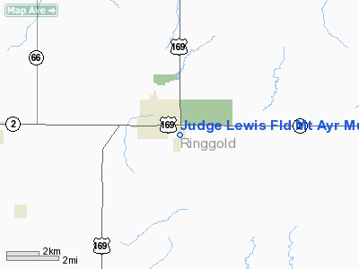
Judge Lewis Field Mount Ayr Municipal Airport |
|
|
Location &
QuickFacts
|
FAA
Information Effective: |
2007-07-05 |
|
Airport
Identifier: |
1Y3 |
|
Airport
Status: |
Operational |
|
Longitude/Latitude: |
094-13-25.8340W/40-42-19.9740N
-94.223843/40.705548 (Estimated) |
|
Elevation: |
1265 ft / 385.57 m (Estimated) |
|
Land: |
29 acres |
|
From
nearest city: |
2 nautical miles SE of Mount Ayr, IA |
|
Location: |
Ringgold County, IA |
|
Magnetic Variation: |
05E (1985) |
Owner & Manager
|
Ownership: |
Publicly owned |
|
Owner: |
City Of Mount Ayr |
|
Address: |
City Hall
Mount Ayr, IA 50854 |
|
Phone
number: |
641-464-2402 |
|
Manager: |
Dan Cunning |
|
Address: |
112 West Madison
Mount Ayr, IA 50854 |
|
Phone number: |
641-464-2242 |
Airport Operations and Facilities
|
Airport
Use: |
Open to public |
|
Wind
indicator: |
Yes |
|
Segmented Circle: |
No |
|
Control
Tower: |
No |
|
Lighting
Schedule: |
DUSK-DAWN |
|
Landing
fee charge: |
No |
|
Sectional chart: |
Omaha |
|
Region: |
ACE - Central |
|
Boundary
ARTCC: |
ZMP - Minneapolis |
|
Tie-in
FSS: |
FOD - Fort Dodge |
|
FSS on
Airport: |
No |
|
FSS
Phone: |
515-955-8114 |
|
FSS Toll
Free: |
1-800-WX-BRIEF |
|
NOTAMs
Facility: |
FOD (NOTAM-d service avaliable) |
Airport Communications
Airport Services
|
Airframe
Repair: |
NONE |
|
Power
Plant Repair: |
NONE |
|
Bottled
Oxygen: |
NONE |
|
Bulk
Oxygen: |
NONE |
|
Runway Information
Runway 17/35
|
Dimension: |
2600 x 40 ft / 792.5 x 12.2 m |
|
Surface: |
GRVL-TRTD, Good Condition |
|
Edge Lights: |
Non-standard lighting system
NSTD LIRL; RWY LGTS ARE 60 FT FM CNTRLN. |
|
|
Runway 17
|
Runway 35
|
|
Traffic
Pattern: |
Left |
Left |
|
Obstruction: |
36 ft tree, 850.0 ft from runway, 90 ft right of
centerline, 23:1 slope to clear |
, 50:1 slope to clear |
|
Radio Navigation Aids
|
ID |
Type |
Name |
Ch |
Freq |
Var |
Dist |
|
UNE |
NDB |
Union County |
|
379.00 |
04E |
16.1 nm |
|
CRZ |
NDB |
Corning |
|
278.00 |
04E |
29.9 nm |
|
ICL |
NDB |
Clarinda |
|
353.00 |
04E |
36.6 nm |
|
EVU |
NDB |
Emville |
|
317.00 |
05E |
38.2 nm |
|
GFZ |
NDB |
Greenfield |
|
338.00 |
04E |
38.6 nm |
|
CNC |
NDB |
Chariton |
|
335.00 |
05E |
43.4 nm |
|
TRX |
NDB |
Trenton |
|
400.00 |
03E |
47.4 nm |
|
LMN |
VORTAC |
Lamoni |
114X |
116.70 |
07E |
13.4 nm |
Based Aircraft
|
Aircraft based
on field: |
4 |
|
Single Engine
Airplanes: |
3 |
|
Ultralights: |
1 |
Operational
Statistics
Time Period:
2005-05-05 -
2006-05-04
|
Aircraft
Operations: |
29/Week |
|
General
Aviation Local: |
43.2% |
|
General
Aviation Itinerant: |
56.8% |
Judge Lewis Field Mount Ayr Municipal Airport
Address:
Ringgold County, IA
Tel:
641-464-2402,
641-464-2242
Images
and information placed above are from
http://www.airport-data.com/airport/1Y3/
We
thank them for the data!
|
General Info |
| Country |
United
States |
| State |
IOWA
|
| FAA ID |
1Y3
|
| Latitude |
40-42-19.974N |
|
Longitude |
094-13-25.834W |
|
Elevation |
1265
feet |
| Near
City |
MOUNT
AYR |
We don't guarantee the information is fresh and accurate. The data may
be wrong or outdated.
For more up-to-date information please refer to other sources.
|
|


