 |
|
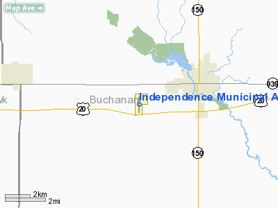
Independence Municipal Airport |
| Independence Municipal Airport |
| IATA: none â ICAO: KIIB â FAA LID: IIB |
| Summary |
| Airport type |
Public |
| Owner |
City of Independence |
| Serves |
Independence, Iowa |
| Elevation AMSL |
979 ft / 298 m |
| Coordinates |
42°27â²25â³N 091°56â²52â³W / 42.45694°N 91.94778°W / 42.45694; -91.94778 |
| Runways |
| Direction |
Length |
Surface |
| ft |
m |
| 17/35 |
5,500 |
1,676 |
Concrete |
| Statistics (2009) |
| Aircraft operations |
9,100 |
| Based aircraft |
24 |
| Source: Federal Aviation Administration |
Independence Municipal Airport (ICAO: KIIB, FAA LID: IIB) is a city-owned, public-use airport located three nautical miles (6 km) southwest of the central business district of Independence, a city in Buchanan County, Iowa, United States. As per the FAA's National Plan of Integrated Airport Systems for 2009-2013, it is classified as a general aviation airport.
Although most U.S. airports use the same three-letter location identifier for the FAA and IATA, this airport is assigned IIB by the FAA but has no designation from the IATA.
Facilities and aircraft
Independence Municipal Airport covers an area of 161 acres (65 ha) at an elevation of 979 feet (298 m) above mean sea level. It has one runway designated 17/35 with a concrete surface measuring 5,500 by 100 feet (1,676 x 30 m).
For the 12-month period ending March 26, 2009, the airport had 9,100 aircraft operations, an average of 24 per day: 87% general aviation, 12% military and 1% air taxi. At that time there were 24 aircraft based at this airport: 79% single-engine, 4% multi-engine and 17% ultralight.
The above content comes from Wikipedia and is published under free licenses – click here to read more.
Location &
QuickFacts
|
FAA
Information Effective: |
2007-07-05 |
|
Airport
Identifier: |
IIB |
|
Airport
Status: |
Operational |
|
Longitude/Latitude: |
091-56-51.4260W/42-27-12.9540N
-91.947618/42.453598 (Estimated) |
|
Elevation: |
978 ft / 298.09 m (Surveyed) |
|
Land: |
161 acres |
|
From
nearest city: |
3 nautical miles SW of Independence, IA |
|
Location: |
Buchanan County, IA |
|
Magnetic Variation: |
02E (1985) |
Owner & Manager
|
Ownership: |
Publicly owned |
|
Owner: |
City Of Independence
CITY CLERK DEBRA LYNN. |
|
Address: |
331 1st St. East
Independence, IA 50644 |
|
Phone
number: |
319-334-2780 |
|
Manager: |
Jim Connell |
|
Address: |
1684 - 230th St;po Box 506
Independence, IA 50644-0506 |
|
Phone number: |
319-334-4000 |
Airport Operations and Facilities
|
Airport
Use: |
Open to public |
|
Wind
indicator: |
Yes |
|
Segmented Circle: |
Yes |
|
Control
Tower: |
No |
|
Lighting
Schedule: |
DUSK-DAWN
MIRL RY 17/35 PRESET LOW INTST; TO ACTVT HIGHER INTST & REILS & VASIS
RYS 17 & 35 - CTAF. |
|
Beacon
Color: |
Clear-Green (lighted land airport) |
|
Landing
fee charge: |
No |
|
Sectional chart: |
Chicago |
|
Region: |
ACE - Central |
|
Boundary
ARTCC: |
ZAU - Chicago |
|
Tie-in
FSS: |
FOD - Fort Dodge |
|
FSS on
Airport: |
No |
|
FSS
Phone: |
515-955-8114 |
|
FSS Toll
Free: |
1-800-WX-BRIEF |
|
NOTAMs
Facility: |
IIB (NOTAM-d service avaliable) |
|
Federal Agreements: |
NGY |
Airport Communications
|
CTAF: |
122.800 |
|
Unicom: |
122.800 |
Airport Services
|
Fuel
available: |
100LLA |
|
Airframe
Repair: |
MAJOR |
|
Power
Plant Repair: |
MAJOR |
|
Bottled
Oxygen: |
NONE |
|
Bulk
Oxygen: |
NONE |
|
Runway Information
Runway 17/35
|
Dimension: |
4000 x 75 ft / 1219.2 x 22.9 m |
|
Surface: |
CONC, Fair Condition |
|
Weight Limit: |
Single wheel: 12000 lbs.
Dual wheel: 16000 lbs. |
|
Edge Lights: |
Medium |
|
|
Runway 17
|
Runway 35
|
|
Longitude: |
091-56-51.6930W |
091-56-51.1670W |
|
Latitude: |
42-27-32.6700N |
42-26-53.1550N |
|
Elevation: |
963.00 ft |
978.00 ft |
|
Alignment: |
127 |
127 |
|
Traffic
Pattern: |
Left |
Left |
|
Markings: |
Non-precision instrument, Fair Condition |
Non-precision instrument, Fair Condition |
|
Crossing
Height: |
29.00 ft |
26.00 ft |
|
VASI: |
2-box on left side |
2-box on left side |
|
Visual
Glide Angle: |
3.00° |
3.00° |
|
Runway End
Identifier: |
Yes |
Yes |
|
Obstruction: |
, 50:1 slope to clear |
13 ft road, 700.0 ft from runway, 38:1 slope to clear |
|
Radio Navigation Aids
|
ID |
Type |
Name |
Ch |
Freq |
Var |
Dist |
|
IIB |
NDB |
Wapsie |
|
206.00 |
02E |
0.2 nm |
|
OLZ |
NDB |
Oelwein |
|
260.00 |
02E |
13.9 nm |
|
VTI |
NDB |
Garrison |
|
338.00 |
03E |
14.3 nm |
|
XWY |
NDB |
West Union |
|
278.00 |
02E |
30.4 nm |
|
TZT |
NDB |
Belle Plaine |
|
371.00 |
02E |
37.3 nm |
|
MXO |
NDB |
Monticello |
|
397.00 |
01E |
39.1 nm |
|
CCY |
NDB |
Charles City |
|
375.00 |
03E |
47.1 nm |
|
MIW |
NDB |
Marshalltown |
|
239.00 |
03E |
47.8 nm |
|
CID |
VOR/DME |
Cedar Rapids |
088X |
114.10 |
05E |
34.8 nm |
|
JWJ |
VOR/DME |
Elmwood |
031X |
109.40 |
03E |
47.4 nm |
|
ALO |
VORTAC |
Waterloo |
059X |
112.20 |
06E |
20.9 nm |
Based Aircraft
|
Aircraft based
on field: |
30 |
|
Single Engine
Airplanes: |
23 |
|
Multi Engine
Airplanes: |
2 |
|
Helicopters: |
1 |
|
Ultralights: |
4 |
Operational Statistics
Time Period:
2004-08-19 -
2005-08-18
|
Aircraft
Operations: |
197/Week |
|
General
Aviation Local: |
65.0% |
|
General
Aviation Itinerant: |
32.3% |
|
Military: |
2.7% |
Independence Municipal Airport
Address:
Buchanan County, IA
Tel:
319-334-2780,
319-334-4000
Images
and information placed above are from
http://www.airport-data.com/airport/IIB/
We
thank them for the data!
|
General Info |
| Country |
United
States |
| State |
IOWA
|
| FAA ID |
IIB
|
| Latitude |
42-27-12.954N |
|
Longitude |
091-56-51.426W |
|
Elevation |
978 feet
|
| Near
City |
INDEPENDENCE |
We don't guarantee the information is fresh and accurate. The data may
be wrong or outdated.
For more up-to-date information please refer to other sources.
|
|


