 |
|
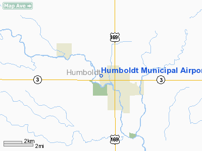
Humboldt Municipal Airport |
|
|
Location &
QuickFacts
|
FAA
Information Effective: |
2007-07-05 |
|
Airport
Identifier: |
0K7 |
|
Airport
Status: |
Operational |
|
Longitude/Latitude: |
094-14-42.8700W/42-44-09.8970N
-94.245242/42.736083 (Estimated) |
|
Elevation: |
1093 ft / 333.15 m (Estimated) |
|
Land: |
50 acres |
|
From
nearest city: |
1 nautical miles W of Humboldt, IA |
|
Location: |
Humboldt County, IA |
|
Magnetic Variation: |
04E (1985) |
Owner & Manager
|
Ownership: |
Publicly owned |
|
Owner: |
City Of Humboldt |
|
Address: |
29 5th St. South P.o. Box 529
Humboldt, IA 50548 |
|
Phone number: |
515-332-3435 |
|
Manager: |
Dave Dodgen |
|
Address: |
709 North Taft
Humboldt, IA 50548 |
|
Phone number: |
515-332-1863 |
Airport
Operations and Facilities
|
Airport
Use: |
Open to public |
|
Wind
indicator: |
Yes |
|
Segmented Circle: |
No |
|
Control
Tower: |
No |
|
Lighting
Schedule: |
DUSK-DAWN
RY LGTS ON LOW INTST DUSK-DAWN; ACTVT CTAF 5 TIMES FOR HIGH INTST
ONLY. |
|
Landing
fee charge: |
No |
|
Sectional chart: |
Omaha |
|
Region: |
ACE - Central |
|
Boundary
ARTCC: |
ZMP - Minneapolis |
|
Tie-in
FSS: |
FOD - Fort Dodge |
|
FSS on
Airport: |
No |
|
FSS
Phone: |
515-955-8114 |
|
FSS Toll
Free: |
1-800-WX-BRIEF |
|
NOTAMs
Facility: |
FOD (NOTAM-d service avaliable) |
|
Federal Agreements: |
N |
Airport Communications
|
CTAF: |
122.800 |
|
Unicom: |
122.800 |
Airport Services
|
Fuel
available: |
100LLMOGAS
FOR FUEL CALL (515) 332-3435. MUST CALL AHEAD FOR FUEL. |
|
Airframe
Repair: |
NONE |
|
Power
Plant Repair: |
NONE |
|
Bottled
Oxygen: |
NONE |
|
Bulk
Oxygen: |
NONE |
|
Runway Information
Runway 12/30
|
Dimension: |
3417 x 60 ft / 1041.5 x 18.3 m |
|
Surface: |
ASPH, Good Condition |
|
Weight Limit: |
Single wheel: 4000 lbs. |
|
Edge Lights: |
Medium |
|
|
Runway 12
|
Runway 30
|
|
Longitude: |
094-15-04.2740W |
094-14-23.0567W |
|
Latitude: |
42-44-12.8735N |
42-43-58.1763N |
|
Elevation: |
1093.00 ft |
1084.00 ft |
|
Alignment: |
116 |
127 |
|
Traffic
Pattern: |
Left |
Left |
|
Markings: |
Basic, Good Condition |
Basic, Good Condition |
|
VASI: |
2-box SAVASI on left side |
2-box SAVASI on left side |
|
Runway End
Identifier: |
|
Yes
REIL OTS INDEFLY. |
|
Obstruction: |
22 ft trees, 428.0 ft from runway, 108 ft left of
centerline, 10:1 slope to clear |
34 ft pole, 890.0 ft from runway, 80 ft right of
centerline, 20:1 slope to clear |
|
Radio Navigation Aids
|
ID |
Type |
Name |
Ch |
Freq |
Var |
Dist |
|
EAG |
NDB |
Eagle Grove |
|
302.00 |
03E |
14.9 nm |
|
POH |
NDB |
Pocahontas |
|
428.00 |
06E |
17.8 nm |
|
AXA |
NDB |
Algona |
|
403.00 |
03E |
20.8 nm |
|
CAV |
NDB |
Clarion |
|
387.00 |
03E |
21.5 nm |
|
EBS |
NDB |
Webster City |
|
323.00 |
03E |
24.3 nm |
|
EGQ |
NDB |
Emmetsburg |
|
410.00 |
04E |
29.9 nm |
|
SKI |
NDB |
Sac City |
|
356.00 |
04E |
39.0 nm |
|
FXY |
NDB |
Forest City |
|
359.00 |
05E |
40.7 nm |
|
PUF |
NDB |
Puff |
|
345.00 |
04E |
42.9 nm |
|
EFW |
NDB |
Jefferson |
|
391.00 |
03E |
43.6 nm |
|
BNW |
NDB |
Boone |
|
407.00 |
03E |
44.5 nm |
|
SLB |
NDB |
Storm Lake |
|
434.00 |
04E |
44.9 nm |
|
HPT |
NDB |
Hampton |
|
230.00 |
03E |
45.1 nm |
|
LTU |
NDB |
Little Sioux |
|
326.00 |
05E |
45.6 nm |
|
IFA |
NDB |
Iowa Falls |
|
368.00 |
03E |
46.1 nm |
|
CIN |
NDB |
Carroll |
|
397.00 |
04E |
48.0 nm |
|
EST |
VOR |
Estherville |
|
110.40 |
07E |
46.0 nm |
|
SPW |
VOR/DME |
Spencer |
037X |
110.00 |
05E |
49.2 nm |
|
FOD |
VORTAC |
Fort Dodge |
082X |
113.50 |
07E |
7.8 nm |
|
MCW |
VORTAC |
Mason City |
096X |
114.90 |
06E |
45.7 nm |
Remarks
-
<
APRX SFC CONICAL PENTS ARPT E 5125?
MSL 1340? TWR>
-
FOR SVC AFT HRS
CALL POLICE DISPATCH AT (515) 332-2600.
-
MIGRATORY BIRD
HAZARD ON & INVOF ARPT.
Based
Aircraft
|
Aircraft based
on field: |
16 |
|
Single Engine
Airplanes: |
16 |
Operational Statistics
Time Period:
2005-07-14 -
2006-07-13
|
Aircraft
Operations: |
103/Week |
|
General
Aviation Local: |
43.2% |
|
General
Aviation Itinerant: |
56.8% |
Humboldt Municipal Airport
Address:
Humboldt County, IA
Tel:
515-332-3435, 515-332-1863
Images
and information placed above are from
http://www.airport-data.com/airport/0K7/
We
thank them for the data!
|
General Info |
| Country |
United
States |
| State |
IOWA
|
| FAA ID |
0K7
|
| Latitude |
42-44-09.897N |
|
Longitude |
094-14-42.870W |
|
Elevation |
1110
feet |
| Near
City |
HUMBOLDT
|
We don't guarantee the information is fresh and accurate. The data may
be wrong or outdated.
For more up-to-date information please refer to other sources.
|
|


