 |
|
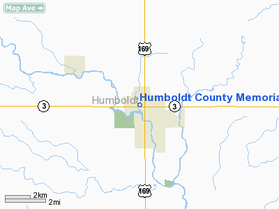
Humboldt County Memorial Hospital Heliport |
Location &
QuickFacts
|
FAA
Information Effective: |
2007-07-05 |
|
Airport
Identifier: |
IA90 |
|
Airport
Status: |
Operational |
|
Longitude/Latitude: |
094-13-53.8670W/42-43-58.8970N
-94.231630/42.733027 (Estimated) |
|
Elevation: |
1102 ft / 335.89 m (Estimated) |
|
Land: |
0 acres |
|
From
nearest city: |
0 nautical miles N of Humboldt, IA |
|
Location: |
Humboldt County, IA |
|
Magnetic Variation: |
04E (1995) |
Owner & Manager
|
Ownership: |
Privately owned |
|
Owner: |
Humboldt County Memorial Hospital |
|
Address: |
1000 N. 15th Street
Humboldt, IA 50548 |
|
Phone
number: |
515-332-4200 |
|
Manager: |
Kari Engholm |
|
Address: |
1000 N. 15th Street
Humboldt, IA 50548 |
|
Phone number: |
515-332-4200 |
Airport Operations and Facilities
|
Airport
Use: |
Private
MEDICAL USE. |
|
Wind
indicator: |
Yes |
|
Segmented Circle: |
No |
|
Control
Tower: |
No |
|
Lighting
Schedule: |
PHONE REQ
FOR PERIMETER LGTS CALL 515-332-4200. |
|
Region: |
ACE - Central |
|
Boundary
ARTCC: |
ZMP - Minneapolis |
|
Tie-in
FSS: |
FOD - Fort Dodge |
|
FSS
Phone: |
515-955-8114 |
|
FSS Toll
Free: |
1-800-WX-BRIEF |
|
Runway Information
Helipad H1
|
Dimension: |
40 x 40 ft / 12.2 x 12.2 m |
|
Surface: |
CONC, |
|
|
Runway H1
|
Runway
|
|
Traffic
Pattern: |
Left |
Left |
|
Radio Navigation Aids
|
ID |
Type |
Name |
Ch |
Freq |
Var |
Dist |
|
EAG |
NDB |
Eagle Grove |
|
302.00 |
03E |
14.3 nm |
|
POH |
NDB |
Pocahontas |
|
428.00 |
06E |
18.4 nm |
|
CAV |
NDB |
Clarion |
|
387.00 |
03E |
20.9 nm |
|
AXA |
NDB |
Algona |
|
403.00 |
03E |
21.0 nm |
|
EBS |
NDB |
Webster City |
|
323.00 |
03E |
23.8 nm |
|
EGQ |
NDB |
Emmetsburg |
|
410.00 |
04E |
30.5 nm |
|
SKI |
NDB |
Sac City |
|
356.00 |
04E |
39.4 nm |
|
FXY |
NDB |
Forest City |
|
359.00 |
05E |
40.4 nm |
|
PUF |
NDB |
Puff |
|
345.00 |
04E |
43.3 nm |
|
EFW |
NDB |
Jefferson |
|
391.00 |
03E |
43.5 nm |
|
BNW |
NDB |
Boone |
|
407.00 |
03E |
44.1 nm |
|
HPT |
NDB |
Hampton |
|
230.00 |
03E |
44.5 nm |
|
IFA |
NDB |
Iowa Falls |
|
368.00 |
03E |
45.4 nm |
|
SLB |
NDB |
Storm Lake |
|
434.00 |
04E |
45.5 nm |
|
LTU |
NDB |
Little Sioux |
|
326.00 |
05E |
46.2 nm |
|
CIN |
NDB |
Carroll |
|
397.00 |
04E |
48.1 nm |
|
EST |
VOR |
Estherville |
|
110.40 |
07E |
46.5 nm |
|
SPW |
VOR/DME |
Spencer |
037X |
110.00 |
05E |
49.8 nm |
|
FOD |
VORTAC |
Fort Dodge |
082X |
113.50 |
07E |
7.8 nm |
|
MCW |
VORTAC |
Mason City |
096X |
114.90 |
06E |
45.3 nm |
Remarks
-
SEE AIRSPACE
LETTER DATED DEC. 20, 1996.
Humboldt County Memorial Hospital Heliport
Address:
Humboldt County, IA
Tel:
515-332-4200
Images
and information placed above are from
http://www.airport-data.com/airport/IA90/
We
thank them for the data!
|
General Info |
| Country |
United
States |
| State |
IOWA
|
| FAA ID |
IA90
|
| Latitude |
42-43-58.897N |
|
Longitude |
094-13-53.867W |
|
Elevation |
1102
feet |
| Near
City |
HUMBOLDT
|
We don't guarantee the information is fresh and accurate. The data may
be wrong or outdated.
For more up-to-date information please refer to other sources.
|
|


