 |
|
|
|
Location &
QuickFacts
|
FAA
Information Effective: |
2007-07-05 |
|
Airport
Identifier: |
85IA |
|
Airport
Status: |
Operational |
|
Longitude/Latitude: |
092-41-50.6840W/43-10-42.9010N
-92.697412/43.178584 (Estimated) |
|
Elevation: |
1125 ft / 342.90 m (Surveyed) |
|
Land: |
80 acres |
|
From
nearest city: |
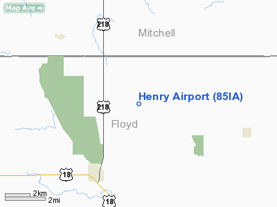
3 nautical miles NE of Floyd, IA |
|
Location: |
Floyd County, IA |
|
Magnetic Variation: |
03E (1985) |
Owner & Manager
|
Ownership: |
Privately owned |
|
Owner: |
Del Henry |
|
Address: |
1245 Rampart Ave
Floyd, IA 50435 |
|
Phone number: |
641-228-2995 |
|
Manager: |
Del Henry |
|
Address: |
1245 Rampart Ave
Floyd, IA 50435 |
|
Phone number: |
641-228-2995 |
Airport Operations and Facilities
|
Airport Use: |
Private |
|
Wind indicator: |
Yes |
|
Segmented Circle: |
No |
|
Control Tower: |
No |
|
Landing fee charge: |
No |
|
Sectional chart: |
Chicago |
|
Region: |
ACE - Central |
|
Boundary ARTCC: |
ZMP - Minneapolis |
|
Tie-in FSS: |
FOD - Fort Dodge |
|
FSS on Airport: |
No |
|
FSS Phone: |
515-955-8114 |
|
FSS Toll Free: |
1-800-WX-BRIEF |
Airport Services
|
Fuel
available: |
100 80 |
|
Airframe
Repair: |
MINOR |
|
Power
Plant Repair: |
MINOR |
|
Runway Information
Runway 17/35
|
Dimension: |
2200 x 75 ft / 670.6 x 22.9 m |
|
Surface: |
TURF, |
|
|
Runway 17
|
Runway 35
|
|
Traffic
Pattern: |
Left |
Left |
|
Radio Navigation Aids
|
ID |
Type |
Name |
Ch |
Freq |
Var |
Dist |
|
IY |
NDB |
Chukk |
|
417.00 |
03E |
3.0 nm |
|
CCY |
NDB |
Charles City |
|
375.00 |
03E |
7.7 nm |
|
CJJ |
NDB |
Cresco |
|
293.00 |
02E |
27.2 nm |
|
HPT |
NDB |
Hampton |
|
230.00 |
03E |
35.8 nm |
|
FXY |
NDB |
Forest City |
|
359.00 |
05E |
40.6 nm |
|
DEH |
NDB |
Decorah |
|
236.00 |
01E |
42.5 nm |
|
XWY |
NDB |
West Union |
|
278.00 |
02E |
42.6 nm |
|
OLZ |
NDB |
Oelwein |
|
260.00 |
02E |
43.5 nm |
|
IFA |
NDB |
Iowa Falls |
|
368.00 |
03E |
49.1 nm |
|
JAY |
VOR/DME |
Austin |
019X |
108.20 |
03E |
25.8 nm |
|
RST |
VOR/DME |
Rochester |
057X |
112.00 |
05E |
36.6 nm |
|
AEL |
VOR/DME |
Albert Lea |
035X |
109.80 |
05E |
42.2 nm |
|
MCW |
VORTAC |
Mason City |
096X |
114.90 |
06E |
28.2 nm |
|
ALO |
VORTAC |
Waterloo |
059X |
112.20 |
06E |
39.6 nm |
Remarks
-
E111 PRVDD APCH
TO EACH RWY IS MAINTD FOR A MIN 20:1 GLIDE SLOPE AND TRANSITIONAL SFC MAINTD
FOR A 7:1 SLOPE.
Based
Aircraft
|
Aircraft based
on field: |
1 |
|
Single Engine
Airplanes: |
1 |
Henry Airport
Address:
Floyd County, IA
Tel:
641-228-2995
Images
and information placed above are from
http://www.airport-data.com/airport/85IA/
We
thank them for the data!
|
General Info |
| Country |
United
States |
| State |
IOWA
|
| FAA ID |
85IA
|
| Latitude |
43-10-42.901N |
|
Longitude |
092-41-50.684W |
|
Elevation |
1125
feet |
| Near
City |
FLOYD
|
We don't guarantee the information is fresh and accurate. The data may
be wrong or outdated.
For more up-to-date information please refer to other sources.
|
|


