 |
|
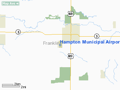
Hampton Municipal Airport |
|
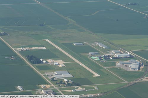 |
(Click on the photo to enlarge) |
Location &
QuickFacts
|
FAA
Information Effective: |
2007-07-05 |
|
Airport
Identifier: |
HPT |
|
Airport
Status: |
Operational |
|
Longitude/Latitude: |
093-13-34.8260W/42-43-25.4050N
-93.226341/42.723724 (Estimated) |
|
Elevation: |
1176 ft / 358.44 m (Surveyed) |
|
Land: |
78 acres |
|
From
nearest city: |
2 nautical miles SW of Hampton, IA |
|
Location: |
Franklin County, IA |
|
Magnetic Variation: |
03E (1995) |
Owner & Manager
|
Ownership: |
Publicly owned |
|
Owner: |
City Of Hampton |
|
Address: |
122 1st Ave. Nw P.o. Box 136
Hampton, IA 50441 |
|
Phone
number: |
641-456-4853 |
|
Manager: |
Chuck Genz
MCCANDLESS AVIONICS, FBO. |
|
Address: |
1274 B Olive Ave
Hampton, IA 50441 |
|
Phone number: |
641-456-4500 |
Airport Operations and Facilities
|
Airport
Use: |
Open to public |
|
Wind
indicator: |
Yes |
|
Segmented Circle: |
No |
|
Control
Tower: |
No |
|
Lighting
Schedule: |
DUSK-DAWN
ACTVT MIRL RY 17/35; PAPI RYS 17 &35 - CTAF. |
|
Beacon
Color: |
Clear-Green (lighted land airport) |
|
Landing
fee charge: |
No |
|
Sectional chart: |
Omaha |
|
Region: |
ACE - Central |
|
Boundary
ARTCC: |
ZMP - Minneapolis |
|
Responsible ARTCC: |
ZMP - Minneapolis |
|
Tie-in
FSS: |
FOD - Fort Dodge |
|
FSS on
Airport: |
No |
|
FSS
Phone: |
515-955-8114 |
|
FSS Toll
Free: |
1-800-WX-BRIEF |
|
NOTAMs
Facility: |
FOD (NOTAM-d service avaliable) |
|
Federal Agreements: |
NGY |
Airport Communications
|
CTAF: |
122.700 |
|
Unicom: |
122.700 |
Airport Services
|
Fuel
available: |
100LLA |
|
Airframe
Repair: |
MINOR |
|
Power
Plant Repair: |
MINOR |
|
Bottled
Oxygen: |
NONE |
|
Bulk
Oxygen: |
NONE |
|
Runway Information
Runway 17/35
|
Dimension: |
4018 x 75 ft / 1224.7 x 22.9 m |
|
Surface: |
CONC, Good Condition |
|
Weight Limit: |
Single wheel: 12000 lbs. |
|
Edge Lights: |
Medium |
|
|
Runway 17
|
Runway 35
|
|
Longitude: |
093-13-34.6030W |
093-13-34.9870W |
|
Latitude: |
42-43-45.1470N |
42-43-05.6630N |
|
Elevation: |
1176.00 ft |
1158.00 ft |
|
Alignment: |
127 |
0 |
|
Traffic
Pattern: |
Left |
Left |
|
Markings: |
Non-precision instrument, Good Condition |
Non-precision instrument, Good Condition |
|
Crossing
Height: |
26.00 ft |
26.00 ft |
|
VASI: |
2-light PAPI on left side |
2-light PAPI on left side |
|
Visual
Glide Angle: |
3.00° |
3.00° |
|
Runway End
Identifier: |
Yes |
Yes |
|
Obstruction: |
20 ft road, 600.0 ft from runway, 20:1 slope to clear |
48 ft tree, 1426.0 ft from runway, 260 ft left of
centerline, 25:1 slope to clear |
|
Radio Navigation Aids
|
ID |
Type |
Name |
Ch |
Freq |
Var |
Dist |
|
HPT |
NDB |
Hampton |
|
230.00 |
03E |
0.1 nm |
|
IFA |
NDB |
Iowa Falls |
|
368.00 |
03E |
15.0 nm |
|
CAV |
NDB |
Clarion |
|
387.00 |
03E |
23.5 nm |
|
EAG |
NDB |
Eagle Grove |
|
302.00 |
03E |
30.2 nm |
|
IY |
NDB |
Chukk |
|
417.00 |
03E |
33.0 nm |
|
EBS |
NDB |
Webster City |
|
323.00 |
03E |
33.1 nm |
|
CCY |
NDB |
Charles City |
|
375.00 |
03E |
34.2 nm |
|
FXY |
NDB |
Forest City |
|
359.00 |
05E |
35.3 nm |
|
MIW |
NDB |
Marshalltown |
|
239.00 |
03E |
39.4 nm |
|
BNW |
NDB |
Boone |
|
407.00 |
03E |
48.9 nm |
|
JWJ |
VOR/DME |
Elmwood |
031X |
109.40 |
03E |
39.4 nm |
|
MCW |
VORTAC |
Mason City |
096X |
114.90 |
06E |
22.8 nm |
|
ALO |
VORTAC |
Waterloo |
059X |
112.20 |
06E |
37.9 nm |
|
FOD |
VORTAC |
Fort Dodge |
082X |
113.50 |
07E |
47.7 nm |
Based Aircraft
|
Aircraft based
on field: |
14 |
|
Single Engine
Airplanes: |
14 |
Operational Statistics
Time Period:
2005-09-22 -
2006-09-21
|
Aircraft
Operations: |
137/Week |
|
General
Aviation Local: |
60.0% |
|
General
Aviation Itinerant: |
40.0% |
Hampton Municipal Airport
Address:
Franklin County, IA
Tel:
641-456-4853,
641-456-4500
Images
and information placed above are from
http://www.airport-data.com/airport/HPT/
We
thank them for the data!
|
General Info |
| Country |
United
States |
| State |
IOWA
|
| FAA ID |
HPT
|
| Latitude |
42-43-25.405N |
|
Longitude |
093-13-34.826W |
|
Elevation |
1176
feet |
| Near
City |
HAMPTON
|
We don't guarantee the information is fresh and accurate. The data may
be wrong or outdated.
For more up-to-date information please refer to other sources.
|
|


