 |
|
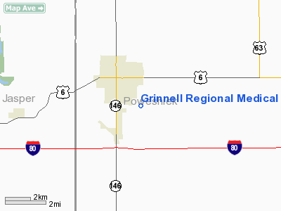
Grinnell Regional Medical Center Heliport |
Location &
QuickFacts
|
FAA
Information Effective: |
2007-07-05 |
|
Airport
Identifier: |
IA09 |
|
Airport
Status: |
Operational |
|
Longitude/Latitude: |
092-42-12.6830W/41-43-32.9790N
-92.703523/41.725828 (Estimated) |
|
Elevation: |
18 ft / 5.49 m (Estimated) |
|
Land: |
0 acres |
|
From
nearest city: |
0 nautical miles N of Grinnell, IA |
|
Location: |
Poweshiek County, IA |
|
Magnetic Variation: |
03E (1995) |
Owner & Manager
|
Ownership: |
Privately owned |
|
Owner: |
Grinnell Regional Medical Center |
|
Address: |
210 4th Ave
Grinnell, IA 50112 |
|
Phone number: |
515-236-2414 |
|
Manager: |
Safety Director |
|
Address: |
210 4th Ave
Grinnell, IA 50112 |
|
Phone number: |
515-236-2414 |
Airport
Operations and Facilities
|
Airport
Use: |
Private
MEDICAL USE. |
|
Segmented Circle: |
No |
|
Control
Tower: |
No |
|
Region: |
ACE - Central |
|
Boundary
ARTCC: |
ZAU - Chicago |
|
Tie-in
FSS: |
FOD - Fort Dodge |
|
FSS
Phone: |
515-955-8114 |
|
FSS Toll
Free: |
1-800-WX-BRIEF |
|
Runway Information
Helipad H1
|
Dimension: |
54 x 54 ft / 16.5 x 16.5 m |
|
Surface: |
CONC, |
|
|
Runway H1
|
Runway
|
|
Traffic
Pattern: |
Left |
Left |
|
Radio Navigation Aids
|
ID |
Type |
Name |
Ch |
Freq |
Var |
Dist |
|
GGI |
NDB |
Grinnell |
|
248.00 |
02E |
1.5 nm |
|
TZT |
NDB |
Belle Plaine |
|
371.00 |
02E |
21.1 nm |
|
PEA |
NDB |
Pella |
|
257.00 |
02E |
22.1 nm |
|
MIW |
NDB |
Marshalltown |
|
239.00 |
03E |
25.0 nm |
|
OOA |
NDB |
Oskaloosa |
|
414.00 |
03E |
31.6 nm |
|
OXV |
NDB |
Knoxville |
|
284.00 |
03E |
31.8 nm |
|
IKV |
NDB |
Ankeny |
|
275.00 |
03E |
38.6 nm |
|
VTI |
NDB |
Garrison |
|
338.00 |
03E |
42.7 nm |
|
TNU |
VOR/DME |
Newton |
072X |
112.50 |
03E |
18.5 nm |
|
JWJ |
VOR/DME |
Elmwood |
031X |
109.40 |
03E |
24.9 nm |
|
CID |
VOR/DME |
Cedar Rapids |
088X |
114.10 |
05E |
42.3 nm |
|
OTM |
VOR/DME |
Ottumwa |
053X |
111.60 |
06E |
45.2 nm |
|
DSM |
VORTAC |
Des Moines |
122X |
117.50 |
07E |
45.9 nm |
|
DSM |
VOT |
Des Moines |
|
109.20 |
|
45.0 nm |
Remarks
-
OWNER DESIRES
HELIPORT NOT BE CHARTED.
-
PRVDD THE FATO,
APCH SFC, & TRANSITIONAL SFCS CLEAR OF OBSTNS; RADIO TWR NE SIDE OF HELIPORT
LGTD & MKD; EMS PERSONNEL USED TO CONTROL ACCESS TO HELIPAD FM RAMP AREA; &
HOSPITAL MAINTAINS FIRE EXTINGUISHER & COORDINATION WITH GRINNELL FIRE DEPT IN
THE EVENT OF A FIRE.
Grinnell Regional Medical Center Heliport
Address:
Poweshiek County, IA
Tel:
515-236-2414
Images
and information placed above are from
http://www.airport-data.com/airport/IA09/
We
thank them for the data!
|
General Info |
| Country |
United
States |
| State |
IOWA
|
| FAA ID |
IA09
|
| Latitude |
41-43-32.979N |
|
Longitude |
092-42-12.683W |
|
Elevation |
18 feet
|
| Near
City |
GRINNELL
|
We don't guarantee the information is fresh and accurate. The data may
be wrong or outdated.
For more up-to-date information please refer to other sources.
|
|


