 |
|
Grinnell Regional Airport |
|
|
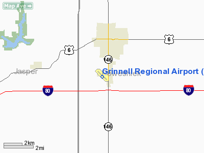
Location &
QuickFacts
|
FAA
Information Effective: |
2007-07-05 |
|
Airport
Identifier: |
GGI |
|
Airport
Status: |
Operational |
|
Longitude/Latitude: |
092-44-05.6860W/41-42-32.9790N
-92.734913/41.709161 (Estimated) |
|
Elevation: |
1008 ft / 307.24 m (Estimated) |
|
Land: |
115 acres |
|
From
nearest city: |
1 nautical miles S of Grinnell, IA |
|
Location: |
Poweshiek County, IA |
|
Magnetic Variation: |
02E (2000) |
Owner & Manager
|
Ownership: |
Publicly owned |
|
Owner: |
City Of Grinnell |
|
Address: |
City Hall 927 4th Ave
Grinnell, IA 50112 |
|
Phone
number: |
641-236-2605 |
|
Manager: |
William Owen |
|
Address: |
1607 W St S
Grinnell, IA 50112 |
|
Phone number: |
641-236-8007 |
Airport Operations and Facilities
|
Airport
Use: |
Open to public |
|
Wind
indicator: |
Yes |
|
Segmented Circle: |
No |
|
Control
Tower: |
No |
|
Lighting
Schedule: |
DUSK-DAWN
MIRL RY 13/31 PRESET ON LOW INTST; TO INCR INTST & ACTVT PAPI & REIL
RYS 13 & 31- CTAF. |
|
Beacon
Color: |
Clear-Green (lighted land airport) |
|
Sectional chart: |
Chicago |
|
Region: |
ACE - Central |
|
Boundary
ARTCC: |
ZAU - Chicago |
|
Tie-in
FSS: |
FOD - Fort Dodge |
|
FSS
Phone: |
515-955-8114 |
|
FSS Toll
Free: |
1-800-WX-BRIEF |
|
NOTAMs
Facility: |
GGI (NOTAM-d service avaliable) |
|
Federal Agreements: |
NGY |
Airport Communications
|
CTAF: |
122.800 |
|
Unicom: |
122.800 |
Airport Services
|
Fuel
available: |
100LLA
FOR FUEL AFT HRS CALL (641) 236-3019. |
|
Runway Information
Runway 13/31
|
Dimension: |
5200 x 75 ft / 1585.0 x 22.9 m |
|
Surface: |
CONC, Good Condition |
|
Weight Limit: |
Single wheel: 30000 lbs.
Dual wheel: 30000 lbs. |
|
Edge Lights: |
Medium |
|
|
Runway 13
|
Runway 31
|
|
Longitude: |
092-44-33.1250W |
092-43-44.3780W |
|
Latitude: |
41-42-53.8410N |
41-42-17.7160N |
|
Elevation: |
989.00 ft |
1008.00 ft |
|
Alignment: |
127 |
127 |
|
Traffic
Pattern: |
Left |
Left |
|
Markings: |
Non-precision instrument, Fair Condition |
Non-precision instrument, Fair Condition |
|
Crossing
Height: |
34.00 ft |
34.00 ft |
|
Displaced
threshold: |
200.00 ft |
200.00 ft |
|
VASI: |
2-light PAPI on left side |
2-light PAPI on left side |
|
Visual
Glide Angle: |
3.00° |
3.30° |
|
Runway End
Identifier: |
Yes |
Yes |
|
Obstruction: |
30 ft pole, 1080.0 ft from runway, 225 ft right of
centerline, 29:1 slope to clear
RY 13 APCH SLOPE 42:1 TO DSPLCD THLD. |
47 ft tree, 925.0 ft from runway, 165 ft right of
centerline, 15:1 slope to clear
RY 31 APCH SLOPE 23:1 TO DSPLCD THLD. |
|
Radio Navigation Aids
|
ID |
Type |
Name |
Ch |
Freq |
Var |
Dist |
|
GGI |
NDB |
Grinnell |
|
248.00 |
02E |
0.2 nm |
|
PEA |
NDB |
Pella |
|
257.00 |
02E |
20.5 nm |
|
TZT |
NDB |
Belle Plaine |
|
371.00 |
02E |
22.9 nm |
|
MIW |
NDB |
Marshalltown |
|
239.00 |
03E |
25.4 nm |
|
OXV |
NDB |
Knoxville |
|
284.00 |
03E |
30.1 nm |
|
OOA |
NDB |
Oskaloosa |
|
414.00 |
03E |
31.1 nm |
|
IKV |
NDB |
Ankeny |
|
275.00 |
03E |
37.2 nm |
|
VTI |
NDB |
Garrison |
|
338.00 |
03E |
44.4 nm |
|
TNU |
VOR/DME |
Newton |
072X |
112.50 |
03E |
17.4 nm |
|
JWJ |
VOR/DME |
Elmwood |
031X |
109.40 |
03E |
25.4 nm |
|
CID |
VOR/DME |
Cedar Rapids |
088X |
114.10 |
05E |
43.9 nm |
|
OTM |
VOR/DME |
Ottumwa |
053X |
111.60 |
06E |
44.8 nm |
|
DSM |
VORTAC |
Des Moines |
122X |
117.50 |
07E |
44.2 nm |
|
DSM |
VOT |
Des Moines |
|
109.20 |
|
43.4 nm |
Remarks
-
RY 31 IS CALM
WIND RY.
-
AIRSPACE DETERMINATION
PENDING.
Based Aircraft
|
Aircraft based
on field: |
14 |
|
Single Engine
Airplanes: |
13 |
|
Jet Engine
Airplanes: |
1 |
Operational Statistics
Time Period:
2003-05-08 -
2004-05-06
|
Aircraft
Operations: |
91/Week |
|
General
Aviation Local: |
60.0% |
|
General
Aviation Itinerant: |
40.0% |
Grinnell Regional Airport
Address:
Poweshiek County, IA
Tel:
641-236-2605,
641-236-8007
Images
and information placed above are from
http://www.airport-data.com/airport/GGI/
We
thank them for the data!
|
General Info |
| Country |
United
States |
| State |
IOWA
|
| FAA ID |
GGI
|
| Latitude |
41-42-32.979N |
|
Longitude |
092-44-05.686W |
|
Elevation |
1008
feet |
| Near
City |
GRINNELL
|
We don't guarantee the information is fresh and accurate. The data may
be wrong or outdated.
For more up-to-date information please refer to other sources.
|
|


