 |
|
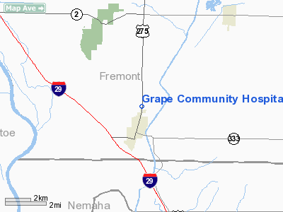
Grape Community Hospital Heliport |
Location &
QuickFacts
|
FAA
Information Effective: |
2007-07-05 |
|
Airport
Identifier: |
2IA5 |
|
Airport
Status: |
Operational |
|
Longitude/Latitude: |
095-38-58.9760W/40-37-21.0040N
-95.649716/40.622501 (Estimated) |
|
Elevation: |
961 ft / 292.91 m (Estimated) |
|
Land: |
0 acres |
|
From
nearest city: |
0 nautical miles S of Hamburg, IA |
|
Location: |
Fremont County, IA |
|
Magnetic Variation: |
06E (1985) |
Owner & Manager
|
Ownership: |
Privately owned |
|
Owner: |
Grape Community Hospital Inc |
|
Address: |
P O Box 246
Hamburg, IA 51640 |
|
Phone
number: |
712-382-1515 |
|
Manager: |
Carolyn Hess, Admin/ceo |
|
Address: |
P O Box 246
Hamburg, IA 51640 |
|
Phone number: |
712-382-1515 |
Airport Operations and Facilities
|
Airport
Use: |
Private
MEDICAL. |
|
Wind
indicator: |
Yes |
|
Segmented Circle: |
Yes |
|
Control
Tower: |
No |
|
Landing
fee charge: |
No |
|
Sectional chart: |
Omaha |
|
Region: |
ACE - Central |
|
Boundary
ARTCC: |
ZMP - Minneapolis |
|
Tie-in
FSS: |
FOD - Fort Dodge |
|
FSS on
Airport: |
No |
|
FSS
Phone: |
515-955-8114 |
|
FSS Toll
Free: |
1-800-WX-BRIEF |
|
Runway Information
Helipad H1
|
Dimension: |
25 x 25 ft / 7.6 x 7.6 m
HELIPAD WITHIN A 120 X 70 TURF LANDING/TAKEOFF AREA. |
|
Surface: |
CONC, |
|
|
Runway H1
|
Runway
|
|
Traffic
Pattern: |
Left |
Left |
|
Radio Navigation Aids
|
ID |
Type |
Name |
Ch |
Freq |
Var |
Dist |
|
AFK |
NDB |
Nebraska City |
|
347.00 |
05E |
9.7 nm |
|
AYB |
NDB |
Auburn |
|
430.00 |
05E |
13.3 nm |
|
SDA |
NDB |
Shenandoah |
|
411.00 |
05E |
13.5 nm |
|
PMV |
NDB |
Plattsmouth |
|
329.00 |
06E |
22.7 nm |
|
ICL |
NDB |
Clarinda |
|
353.00 |
04E |
29.0 nm |
|
RDK |
NDB |
Red Oak |
|
230.00 |
04E |
29.7 nm |
|
FNB |
NDB |
Brenner |
|
404.00 |
05E |
33.0 nm |
|
EVU |
NDB |
Emville |
|
317.00 |
05E |
37.4 nm |
|
MLE |
NDB |
Millard |
|
371.00 |
06E |
40.4 nm |
|
CRZ |
NDB |
Corning |
|
278.00 |
04E |
46.4 nm |
|
OM |
NDB |
Gerfi |
|
320.00 |
05E |
46.9 nm |
|
OFF |
TACAN |
Offutt |
054X |
|
05E |
31.8 nm |
|
RBA |
VOR/DME |
Robinson |
019X |
108.20 |
04E |
47.5 nm |
|
OVR |
VORTAC |
Omaha |
110X |
116.30 |
08E |
33.0 nm |
|
PWE |
VORTAC |
Pawnee City |
071X |
112.40 |
05E |
36.0 nm |
|
OMA |
VOT |
Omaha |
|
109.00 |
|
41.9 nm |
Remarks
-
CONDL: PROVIDED
APPROACH/DEPARTURE PATHS ARE MAINTAINED FOR A MINIMUM 8:1 GLIDE SLOPE AND THE
TRANSITIONAL SURFACE IS MAINTAINED FOR A 2:1 GLIDE SLOPE.
Grape Community Hospital Heliport
Address:
Fremont County, IA
Tel:
712-382-1515
Images
and information placed above are from
http://www.airport-data.com/airport/2IA5/
We
thank them for the data!
|
General Info |
| Country |
United
States |
| State |
IOWA
|
| FAA ID |
2IA5
|
| Latitude |
40-37-21.004N |
|
Longitude |
095-38-58.976W |
|
Elevation |
961 feet
|
| Near
City |
HAMBURG
|
We don't guarantee the information is fresh and accurate. The data may
be wrong or outdated.
For more up-to-date information please refer to other sources.
|
|


