 |
|
Fort Dodge Regional Airport |
| Fort Dodge Regional Airport |
| IATA: FOD â ICAO: KFOD
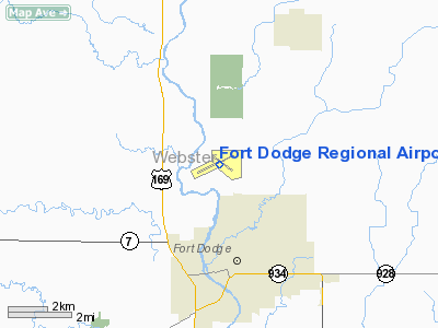
Location of Fort Dodge Regional Airport
|
| Summary |
| Airport type |
Public |
| Operator |
City of Fort Dodge |
| Location |
Fort Dodge, Iowa |
| Elevation AMSL |
1,157 ft / 352.7 m |
| Coordinates |
42°33â²05â³N 94°11â²33â³W / 42.55139°N 94.1925°W / 42.55139; -94.1925Coordinates: 42°33â²05â³N 94°11â²33â³W / 42.55139°N 94.1925°W / 42.55139; -94.1925 |
| Runways |
| Direction |
Length |
Surface |
| ft |
m |
| 6/24 |
6,548 |
1,996 |
Asphalt |
| 12/30 |
5,301 |
1,616 |
Asphalt |
Fort Dodge Regional Airport (IATA: FOD, ICAO: KFOD) is a public airport located three miles (5 km) north of the central business district (CBD) of Fort Dodge, a city in Webster County, Iowa, USA. The airport covers 992 acres (401 ha) and has two runways. It is mostly used for general aviation, but is also served by one commercial airline. Mesaba Airlines, operating as Delta Connection, offers daily service to Minneapolis-St. Paul with a stop in Mason City. Service is subsidized by the Essential Air Service program. Effective on June 10, 2010, the stop in Mason City will end and Fort Dodge will have nonstop flights to Minneapolis-St. Paul. Beginning June 10, 2010, departures from Fort Dodge will be 7:10 AM and 2:27 PM and arrivals will be 12:50 PM and 7:25 PM daily. Scheduled passenger service
| Airlines |
Destinations |
| Delta Connection operated by Mesaba Airlines |
Minneapolis/St. Paul |
Cargo
Flight Express (Des Moines, Mason City) Cessna 210
The above content comes from Wikipedia and is published under free licenses – click here to read more.
Location &
QuickFacts
|
FAA
Information Effective: |
2007-07-05 |
|
Airport
Identifier: |
FOD |
|
Airport
Status: |
Operational |
|
Longitude/Latitude: |
094-11-30.6250W/42-33-04.3180N
-94.191840/42.551199 (Estimated) |
|
Elevation: |
1157 ft / 352.65 m (Surveyed) |
|
Land: |
992 acres |
|
From
nearest city: |
3 nautical miles N of Fort Dodge, IA |
|
Location: |
Webster County, IA |
|
Magnetic Variation: |
05E (1980) |
Owner & Manager
|
Ownership: |
Publicly owned |
|
Owner: |
City Of Fort Dodge |
|
Address: |
819 First Ave South
Fort Dodge, IA 50501 |
|
Phone
number: |
515-573-7144 |
|
Manager: |
Ms. Rhonda Chambers |
|
Address: |
1639 Nelson Ave Suite 2
Fort Dodge, IA 50501 |
|
Phone number: |
515-573-3881 |
Airport Operations and Facilities
|
Airport
Use: |
Open to public |
|
Wind
indicator: |
Yes |
|
Segmented Circle: |
Yes |
|
Control
Tower: |
No |
|
Lighting
Schedule: |
DUSK-DAWN
ACTVT HIRL RY 06/24; MIRL RY 12/30; REIL RYS 12, 24 & 30; MALSR RY 06
& VASI RYS 06; 24; 12 & PAPI RY 30 - CTAF. |
|
Beacon
Color: |
Clear-Green (lighted land airport) |
|
Landing
fee charge: |
No |
|
Sectional chart: |
Omaha |
|
Region: |
ACE - Central |
|
Traffic
Pattern Alt: |
843 ft |
|
Boundary
ARTCC: |
ZMP - Minneapolis |
|
Tie-in
FSS: |
FOD - Fort Dodge |
|
FSS on
Airport: |
Yes |
|
FSS
Phone: |
515-955-8114 |
|
FSS Toll
Free: |
1-800-WX-BRIEF |
|
NOTAMs
Facility: |
FOD (NOTAM-d service avaliable) |
|
Certification type/date: |
I A S 11/1991
PPR 24 HRS FOR UNSKED ACR OPNS WITH MORE THAN 30 PSGR SEATS CALL AMGR
(515) 573-3881. |
|
Federal Agreements: |
NGY |
Airport Communications
|
CTAF: |
122.950 |
|
Unicom: |
122.950 |
Airport Services
|
Fuel
available: |
100LLA |
|
Airframe
Repair: |
MAJOR |
|
Power
Plant Repair: |
MAJOR |
|
Bottled
Oxygen: |
NONE |
|
Bulk
Oxygen: |
NONE |
|
Runway Information
Runway 06/24
|
Dimension: |
6548 x 150 ft / 1995.8 x 45.7 m |
|
Surface: |
ASPH, Good Condition |
|
Weight Limit: |
Single wheel: 65000 lbs.
Dual wheel: 110000 lbs.
Dual tandem wheel: 165000 lbs. |
|
Edge Lights: |
High |
|
|
Runway 06
|
Runway 24
|
|
Longitude: |
094-12-20.6760W |
094-11-01.3970W |
|
Latitude: |
42-32-51.4630N |
42-33-18.7870N |
|
Elevation: |
1080.00 ft |
1157.00 ft |
|
Alignment: |
65 |
127 |
|
ILS Type: |
ILS |
|
|
Traffic
Pattern: |
Left |
Left |
|
Markings: |
Precision instrument, Good Condition |
Non-precision instrument, Good Condition |
|
Crossing
Height: |
55.00 ft |
50.00 ft |
|
VASI: |
4-box on left side |
4-box on left side |
|
Visual
Glide Angle: |
3.00° |
3.00° |
|
Approach
lights: |
MALSR |
|
|
Runway End
Identifier: |
|
Yes |
|
Runway 12/30
|
Dimension: |
5300 x 100 ft / 1615.4 x 30.5 m |
|
Surface: |
ASPH, Fair Condition |
|
Weight Limit: |
Single wheel: 36000 lbs.
Dual wheel: 58000 lbs. |
|
Edge Lights: |
Medium |
|
|
Runway 12
|
Runway 30
|
|
Longitude: |
094-11-46.0493W |
094-10-49.4775W |
|
Latitude: |
42-33-19.0673N |
42-32-47.5755N |
|
Elevation: |
1112.00 ft |
1142.00 ft |
|
Alignment: |
127 |
127 |
|
Traffic
Pattern: |
Left |
Left |
|
Markings: |
Non-precision instrument, Good Condition |
Non-precision instrument, Good Condition |
|
Crossing
Height: |
51.00 ft |
40.00 ft |
|
VASI: |
4-box on left side |
4-light PAPI on left side |
|
Visual
Glide Angle: |
3.00° |
3.00° |
|
Runway End
Identifier: |
Yes |
Yes |
|
Obstruction: |
, 50:1 slope to clear |
30 ft pole, 1340.0 ft from runway, 224 ft left of
centerline, 38:1 slope to clear |
|
Radio Navigation Aids
|
ID |
Type |
Name |
Ch |
Freq |
Var |
Dist |
|
EAG |
NDB |
Eagle Grove |
|
302.00 |
03E |
15.6 nm |
|
EBS |
NDB |
Webster City |
|
323.00 |
03E |
15.7 nm |
|
CAV |
NDB |
Clarion |
|
387.00 |
03E |
22.4 nm |
|
POH |
NDB |
Pocahontas |
|
428.00 |
06E |
23.3 nm |
|
AXA |
NDB |
Algona |
|
403.00 |
03E |
32.1 nm |
|
EFW |
NDB |
Jefferson |
|
391.00 |
03E |
33.0 nm |
|
BNW |
NDB |
Boone |
|
407.00 |
03E |
33.4 nm |
|
SKI |
NDB |
Sac City |
|
356.00 |
04E |
36.5 nm |
|
EGQ |
NDB |
Emmetsburg |
|
410.00 |
04E |
40.1 nm |
|
CIN |
NDB |
Carroll |
|
397.00 |
04E |
40.3 nm |
|
IFA |
NDB |
Iowa Falls |
|
368.00 |
03E |
41.3 nm |
|
PRO |
NDB |
Perry |
|
251.00 |
06E |
43.3 nm |
|
HPT |
NDB |
Hampton |
|
230.00 |
03E |
44.0 nm |
|
SLB |
NDB |
Storm Lake |
|
434.00 |
04E |
46.7 nm |
|
FXY |
NDB |
Forest City |
|
359.00 |
05E |
48.2 nm |
|
FOD |
VORTAC |
Fort Dodge |
082X |
113.50 |
07E |
5.8 nm |
Remarks
-
MIGRATORY
WATERFOWL ON & INVOF ARPT.
-
WHEN DEP RYS
06/24 & 13/30 ENDS OF OTHER RYS NOT VISIBLE. ALL DEP/ARR ACFT USE CTAF.
-
ACR OPNS
INVOLVING ACFT WITH MORE THAN 9 PASSENGER SEATS ARE NOT AUTHORIZED IN EXCESS
OF 15 MINS BEFORE OR AFT SCHEDULED ARR OR DEP TIMES WITHOUT PRIOR COORD WITH
ARPT MANAGEMENT AND/OR ARPT MAINT & CONFIRMATION THAT ARFF SVCS ARE AVBL PRIOR
TO LANDING OR TAKEOFF.
-
RY 06 IS CALM
WIND RY.
Based
Aircraft
|
Aircraft based
on field: |
29 |
|
Single Engine
Airplanes: |
26 |
|
Multi Engine
Airplanes: |
3 |
Operational Statistics
Time Period:
2005-08-01 - 2006-07-31
|
Aircraft
Operations: |
61/Day |
|
Commerical: |
18.0% |
|
Air Taxi: |
2.3% |
|
General
Aviation Local: |
33.8% |
|
General
Aviation Itinerant: |
45.0% |
|
Military: |
0.9% |
Fort Dodge Regional Airport
Address:
Webster County, IA
Tel:
515-573-7144,
515-573-3881
Images
and information placed above are from
http://www.airport-data.com/airport/FOD/
We
thank them for the data!
|
General Info |
| Country |
United
States |
| State |
IOWA
|
| FAA ID |
FOD
|
| Latitude |
42-33-05.242N |
|
Longitude |
094-11-33.184W |
|
Elevation |
1157
feet |
| Near
City |
FORT
DODGE |
We don't guarantee the information is fresh and accurate. The data may
be wrong or outdated.
For more up-to-date information please refer to other sources.
|
|


