 |
|
|
|
|
|
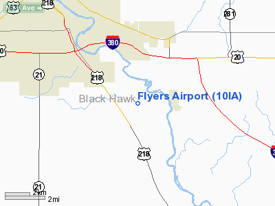
Location &
QuickFacts
|
FAA
Information Effective: |
2007-07-05 |
|
Airport
Identifier: |
10IA |
|
Airport
Status: |
Operational |
|
Longitude/Latitude: |
092-15-00.6600W/42-24-59.9600N
-92.250183/42.416656 (Estimated) |
|
Elevation: |
830 ft / 252.98 m (Estimated) |
|
Land: |
20 acres |
|
From
nearest city: |
6 nautical miles SE of Waterloo, IA |
|
Location: |
Black Hawk County, IA |
|
Magnetic Variation: |
03E (1985) |
Owner & Manager
|
Ownership: |
Privately owned |
|
Owner: |
Ruth Schleusner |
|
Address: |
6831 Weiden Road
Waterloo, IA 50701 |
|
Phone number: |
319-296-3247 |
|
Manager: |
Ruth Schleusner |
|
Address: |
6831 Weiden Road
Waterloo, IA 50701 |
|
Phone number: |
319-296-3247 |
Airport
Operations and Facilities
|
Airport
Use: |
Private |
|
Wind
indicator: |
Yes |
|
Segmented Circle: |
No |
|
Control
Tower: |
No |
|
Lighting
Schedule: |
PHONE REQ
FOR LIRL 17/35 CALL 319-296-3247. |
|
Landing fee charge: |
No |
|
Sectional chart: |
Chicago |
|
Region: |
ACE - Central |
|
Boundary ARTCC: |
ZAU - Chicago |
|
Tie-in FSS: |
FOD - Fort Dodge |
|
FSS on Airport: |
No |
|
FSS Phone: |
515-955-8114 |
|
FSS Toll Free: |
1-800-WX-BRIEF |
Airport Services
|
Fuel
available: |
100LL80 MOGAS |
|
Airframe
Repair: |
NONE |
|
Power
Plant Repair: |
NONE |
|
Bottled
Oxygen: |
NONE |
|
Bulk
Oxygen: |
NONE |
|
Runway Information
Runway 17/35
|
Dimension: |
2405 x 85 ft / 733.0 x 25.9 m |
|
Surface: |
TURF, Good Condition |
|
Edge Lights: |
Non-standard lighting system
NSTD LIRL ON EAST SIDE ONLY; NOT FAA APPROVED L-800 SERIES. RY 17 THR LGTS
SOLID GREEN LENS; RY 17 THR MARKERS 425 FT SOUTH OF THR LGTS. |
|
|
Runway 17
|
Runway 35
|
|
Traffic
Pattern: |
Left |
Left |
|
Obstruction: |
, 50:1 slope to clear |
43 ft pline, 750.0 ft from runway, 17:1 slope to clear |
|
Radio Navigation Aids
|
ID |
Type |
Name |
Ch |
Freq |
Var |
Dist |
|
IIB |
NDB |
Wapsie |
|
206.00 |
02E |
13.4 nm |
|
VTI |
NDB |
Garrison |
|
338.00 |
03E |
15.6 nm |
|
OLZ |
NDB |
Oelwein |
|
260.00 |
02E |
20.1 nm |
|
TZT |
NDB |
Belle Plaine |
|
371.00 |
02E |
32.0 nm |
|
MIW |
NDB |
Marshalltown |
|
239.00 |
03E |
34.9 nm |
|
XWY |
NDB |
West Union |
|
278.00 |
02E |
37.8 nm |
|
CCY |
NDB |
Charles City |
|
375.00 |
03E |
42.2 nm |
|
IFA |
NDB |
Iowa Falls |
|
368.00 |
03E |
45.2 nm |
|
HPT |
NDB |
Hampton |
|
230.00 |
03E |
47.0 nm |
|
GGI |
NDB |
Grinnell |
|
248.00 |
02E |
47.6 nm |
|
IY |
NDB |
Chukk |
|
417.00 |
03E |
48.0 nm |
|
JWJ |
VOR/DME |
Elmwood |
031X |
109.40 |
03E |
34.6 nm |
|
CID |
VOR/DME |
Cedar Rapids |
088X |
114.10 |
05E |
37.9 nm |
|
ALO |
VORTAC |
Waterloo |
059X |
112.20 |
06E |
10.7 nm |
Remarks
-
BE ALERT FOR
FLOCKS OF BIRDS ON & INVOF ARPT.
Based Aircraft
|
Aircraft based
on field: |
22 |
|
Single Engine
Airplanes: |
12 |
|
Ultralights: |
10
ULTRALIGHT ACTIVITY ON & INVOF ARPT. |
Operational Statistics
Time Period:
1992-11-03 - 1993-11-02
|
Aircraft
Operations: |
24/Week |
|
General
Aviation Local: |
83.3% |
|
General
Aviation Itinerant: |
16.7% |
Flyers Airport
Address:
Black Hawk County, IA
Tel:
319-296-3247
Images
and information placed above are from
http://www.airport-data.com/airport/10IA/
We
thank them for the data!
|
General Info |
| Country |
United
States |
| State |
IOWA
|
| FAA ID |
10IA
|
| Latitude |
42-24-59.960N |
|
Longitude |
092-15-00.660W |
|
Elevation |
830 feet
|
| Near
City |
WATERLOO
|
We don't guarantee the information is fresh and accurate. The data may
be wrong or outdated.
For more up-to-date information please refer to other sources.
|
|


