 |
|
Fairfield Municipal Airport |
Coordinates: 41°03â²21â³N 091°58â²51â³W / 41.05583°N 91.98083°W / 41.05583; -91.98083
| Fairfield Municipal Airport |
| IATA: FFL â ICAO: KFFL â FAA LID: FFL |
| Summary |
| Airport type |
Public |
| Owner |
City of Fairfield |
| Serves |
Fairfield, Iowa |
| Elevation AMSL |
799 ft / 244 m |
| Runways |
| Direction |
Length |
Surface |
| ft |
m |
| 18/36 |
5,500 |
1,676 |
Concrete |
| 8/26 |
2,450 |
747 |
Turf |
| Statistics (2005) |
| Aircraft operations |
9,380 |
| Based aircraft |
36 |
| Source: Federal Aviation Administration |
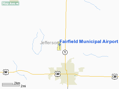
Fairfield Municipal Airport (IATA: FFL, ICAO: KFFL, FAA LID: FFL) is a public airport located three miles (5 km) northwest of the central business district of Fairfield, a city in Jefferson County, Iowa, United States. It is owned by the City of Fairfield. Facilities and aircraft
Fairfield Municipal Airport covers an area of 118 acres (48 ha) which contains two runways: 18/36 with a concrete pavement measuring 5,500 x 100 ft (1,676 x 30 m) and 8/26 with a turf surface 2,450 x 165 ft (747 x 50 m).
For the 12-month period ending November 15, 2005, the airport had 9,380 aircraft operations, an average of 25 per day: 89% general aviation, 9% military and 2% air taxi. There are 36 aircraft based at this airport: 81% single engine, 8% multi-engine, 3% jet and 8% ultralight.
Historical aircraft
A former USAF F-84F Thunderstreak is on static display near the airport terminal.
The above content comes from Wikipedia and is published under free licenses – click here to read more.
Location &
QuickFacts
|
FAA
Information Effective: |
2007-07-05 |
|
Airport
Identifier: |
FFL |
|
Airport
Status: |
Operational |
|
Longitude/Latitude: |
091-58-51.1267W/41-03-21.2047N
-91.980869/41.055890 (Estimated) |
|
Elevation: |
799 ft / 243.54 m (Surveyed) |
|
Land: |
118 acres |
|
From
nearest city: |
3 nautical miles NW of Fairfield, IA |
|
Location: |
Jefferson County, IA |
|
Magnetic Variation: |
03E (1985) |
Owner & Manager
|
Ownership: |
Publicly owned |
|
Owner: |
City Of Fairfield |
|
Address: |
118 South Main
Fairfield, IA 52556 |
|
Phone number: |
641-472-6193 |
|
Manager: |
Robert Lyons |
|
Address: |
2013 Airport Rd
Fairfield, IA 52556 |
|
Phone number: |
641-472-3166 |
Airport
Operations and Facilities
|
Airport
Use: |
Open to public |
|
Wind
indicator: |
Yes |
|
Segmented Circle: |
Yes |
|
Control
Tower: |
No |
|
Lighting
Schedule: |
DUSK-DAWN
MIRL RY 18/36 PRESET ON LOW INTST; TO INCR INTST AND ACTVT REIL RY 36
AND VASI RYS 18 & 36 - CTAF. |
|
Beacon
Color: |
Clear-Green (lighted land airport) |
|
Landing
fee charge: |
No |
|
Sectional chart: |
Chicago |
|
Region: |
ACE - Central |
|
Traffic
Pattern Alt: |
1001 ft |
|
Boundary
ARTCC: |
ZAU - Chicago |
|
Tie-in
FSS: |
FOD - Fort Dodge |
|
FSS on
Airport: |
No |
|
FSS
Phone: |
515-955-8114 |
|
FSS Toll
Free: |
1-800-WX-BRIEF |
|
NOTAMs
Facility: |
FFL (NOTAM-d service avaliable) |
|
Federal Agreements: |
NGY |
Airport Communications
|
CTAF: |
122.700 |
|
Unicom: |
122.700 |
Airport Services
|
Fuel
available: |
100LLA |
|
Airframe
Repair: |
MAJOR |
|
Power
Plant Repair: |
MAJOR |
|
Bottled
Oxygen: |
NONE |
|
Runway Information
Runway 08/26
|
Dimension: |
2450 x 165 ft / 746.8 x 50.3 m |
|
Surface: |
TURF, Good Condition |
|
|
Runway 08
|
Runway 26
|
|
Longitude: |
091-59-12.7500W |
091-58-40.8300W |
|
Latitude: |
41-03-12.0200N |
41-03-13.5200N |
|
Elevation: |
791.00 ft |
791.00 ft |
|
Alignment: |
86 |
127 |
|
Traffic
Pattern: |
Left |
Left |
|
Obstruction: |
6 ft fence, 120.0 ft from runway, 20:1 slope to clear
FENCE 120' FROM RUNWAY END |
4 ft fence, 80.0 ft from runway, 20:1 slope to clear
FENCE 80' FROM RUNWAY END |
|
Runway 18/36
|
Dimension: |
5500 x 100 ft / 1676.4 x 30.5 m |
|
Surface: |
CONC, Fair Condition |
|
Weight Limit: |
Single wheel: 30000 lbs.
Dual wheel: 45000 lbs. |
|
Edge Lights: |
Medium |
|
|
Runway 18
|
Runway 36
|
|
Longitude: |
091-58-48.8350W |
091-58-48.3730W |
|
Latitude: |
41-03-52.1330N |
41-02-57.7910N |
|
Elevation: |
797.00 ft |
792.00 ft |
|
Alignment: |
127 |
127 |
|
Traffic
Pattern: |
Left |
Left |
|
Markings: |
Non-precision instrument, Good Condition |
Non-precision instrument, Good Condition |
|
Crossing
Height: |
40.00 ft |
42.00 ft |
|
VASI: |
2-box on left side
VASI OTS INDEFLY. |
2-box on left side
VASI OTS INDEFLY. |
|
Visual
Glide Angle: |
3.00° |
3.00° |
|
Runway End
Identifier: |
|
Yes |
|
Obstruction: |
15 ft road, 750.0 ft from runway, 36:1 slope to clear |
17 ft road, 1054.0 ft from runway, 50:1 slope to clear |
|
Radio Navigation Aids
|
ID |
Type |
Name |
Ch |
Freq |
Var |
Dist |
|
FFL |
NDB |
Fairfield |
|
332.00 |
03E |
2.7 nm |
|
AWG |
NDB |
Washington |
|
219.00 |
02E |
19.4 nm |
|
MPZ |
NDB |
Mount Pleasant |
|
212.00 |
02E |
22.4 nm |
|
OOA |
NDB |
Oskaloosa |
|
414.00 |
03E |
25.1 nm |
|
BEX |
NDB |
Bloomfield |
|
269.00 |
02E |
27.7 nm |
|
EOK |
NDB |
Keokuk |
|
366.00 |
02E |
43.4 nm |
|
TVK |
NDB |
Centerville |
|
290.00 |
04E |
47.3 nm |
|
PEA |
NDB |
Pella |
|
257.00 |
02E |
48.3 nm |
|
OTM |
VOR/DME |
Ottumwa |
053X |
111.60 |
06E |
15.7 nm |
|
DDD |
VOR/DME |
Port City |
112X |
116.50 |
01E |
42.0 nm |
|
IOW |
VORTAC |
Iowa City |
109X |
116.20 |
05E |
32.4 nm |
Remarks
-
TWY EDGES MARKED
WITH BLUE REFLECTORS.
-
RY 36 IS CALM
WIND RY.
Based
Aircraft
|
Aircraft based
on field: |
36 |
|
Single Engine
Airplanes: |
29 |
|
Multi Engine
Airplanes: |
3 |
|
Jet Engine
Airplanes: |
1 |
|
Ultralights: |
3 |
Operational Statistics
Time Period:
2004-11-16 -
2005-11-15
|
Aircraft
Operations: |
181/Week |
|
Air Taxi: |
2.2% |
|
General
Aviation Local: |
48.5% |
|
General
Aviation Itinerant: |
40.0% |
|
Military: |
9.3% |
Fairfield Municipal Airport
Address:
Jefferson County, IA
Tel:
641-472-6193, 641-472-3166
Images
and information placed above are from
http://www.airport-data.com/airport/FFL/
We
thank them for the data!
|
General Info |
| Country |
United
States |
| State |
IOWA
|
| FAA ID |
FFL
|
| Latitude |
41-03-11.967N |
|
Longitude |
091-58-44.124W |
|
Elevation |
799 feet
|
| Near
City |
FAIRFIELD |
We don't guarantee the information is fresh and accurate. The data may
be wrong or outdated.
For more up-to-date information please refer to other sources.
|
|


