 |
|
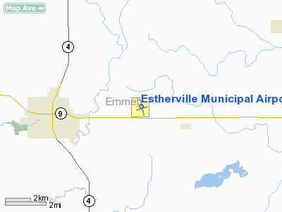
Estherville Municipal Airport |
|
|
Location &
QuickFacts
|
FAA
Information Effective: |
2007-07-05 |
|
Airport
Identifier: |
EST |
|
Airport
Status: |
Operational |
|
Longitude/Latitude: |
094-44-47.2000W/43-24-26.8000N
-94.746444/43.407444 (Estimated) |
|
Elevation: |
1319 ft / 402.03 m (Surveyed) |
|
Land: |
400 acres |
|
From
nearest city: |
4 nautical miles E of Estherville, IA |
|
Location: |
Emmet County, IA |
|
Magnetic Variation: |
06E (1980) |
Owner & Manager
|
Ownership: |
Publicly owned |
|
Owner: |
City Of Estherville |
|
Address: |
2 N 7th St
Estherville, IA 51334 |
|
Phone number: |
712-362-7771 |
|
Manager: |
Paul Slaughter |
|
Address: |
1672 425th Avenue
Estherville, IA 51334 |
|
Phone number: |
712-362-2761 |
Airport
Operations and Facilities
|
Airport
Use: |
Open to public |
|
Wind
indicator: |
Yes |
|
Segmented Circle: |
No |
|
Control
Tower: |
No |
|
Lighting
Schedule: |
DUSK-DAWN
ACTVT MIRL RY 16/34; REIL RYS 16 & 34; PAPI RYS 16 & 34 - CTAF. |
|
Beacon
Color: |
Clear-Green (lighted land airport) |
|
Landing
fee charge: |
No |
|
Sectional chart: |
Omaha |
|
Region: |
ACE - Central |
|
Boundary
ARTCC: |
ZMP - Minneapolis |
|
Tie-in
FSS: |
FOD - Fort Dodge |
|
FSS on
Airport: |
No |
|
FSS
Phone: |
515-955-8114 |
|
FSS Toll
Free: |
1-800-WX-BRIEF |
|
NOTAMs
Facility: |
EST (NOTAM-d service avaliable) |
|
Federal Agreements: |
NGY |
Airport Communications
|
CTAF: |
122.800 |
|
Unicom: |
122.800 |
Airport Services
|
Fuel
available: |
100LL |
|
Airframe
Repair: |
MAJOR |
|
Power
Plant Repair: |
MAJOR |
|
Bottled
Oxygen: |
NONE |
|
Bulk
Oxygen: |
NONE |
|
Runway Information
Runway 06/24
|
Dimension: |
2985 x 90 ft / 909.8 x 27.4 m |
|
Surface: |
TURF, Fair Condition |
|
|
Runway 06
|
Runway 24
|
|
Longitude: |
094-45-04.4000W |
094-44-27.6000W |
|
Latitude: |
43-24-17.8480N |
43-24-25.8000N |
|
Alignment: |
73 |
127 |
|
Traffic
Pattern: |
Left |
Left |
|
Obstruction: |
, 50:1 slope to clear |
15 ft road, 575.0 ft from runway, 38:1 slope to clear |
|
Runway 16/34
|
Dimension: |
4797 x 75 ft / 1462.1 x 22.9 m |
|
Surface: |
CONC, Good Condition |
|
Weight Limit: |
Single wheel: 11000 lbs. |
|
Edge Lights: |
Medium |
|
|
Runway 16
|
Runway 34
|
|
Longitude: |
094-44-53.7039W |
094-44-41.9550W |
|
Latitude: |
43-24-53.0180N |
43-24-06.4276N |
|
Elevation: |
1316.00 ft |
1317.00 ft |
|
Alignment: |
127 |
127 |
|
Traffic
Pattern: |
Left |
Left |
|
Markings: |
Non-precision instrument, Good Condition |
Non-precision instrument, Good Condition |
|
Crossing
Height: |
30.00 ft |
42.00 ft |
|
VASI: |
4-light PAPI on left side |
4-light PAPI on left side |
|
Visual
Glide Angle: |
3.00° |
3.00° |
|
Runway End
Identifier: |
Yes
REIL ARE OMNIDIRECTIONAL. |
Yes |
|
Obstruction: |
, 50:1 slope to clear |
19 ft hwy, 850.0 ft from runway, 34:1 slope to clear |
|
Radio Navigation Aids
|
ID |
Type |
Name |
Ch |
Freq |
Var |
Dist |
|
PUF |
NDB |
Puff |
|
345.00 |
04E |
3.4 nm |
|
MJQ |
NDB |
Jackson |
|
353.00 |
04E |
17.8 nm |
|
EGQ |
NDB |
Emmetsburg |
|
410.00 |
04E |
18.5 nm |
|
LTU |
NDB |
Little Sioux |
|
326.00 |
05E |
23.9 nm |
|
AXA |
NDB |
Algona |
|
403.00 |
03E |
28.5 nm |
|
SBU |
NDB |
Blue Earth |
|
332.00 |
04E |
30.5 nm |
|
MWM |
NDB |
Windom |
|
203.00 |
03E |
34.0 nm |
|
JYG |
NDB |
St James |
|
260.00 |
04E |
35.8 nm |
|
POH |
NDB |
Pocahontas |
|
428.00 |
06E |
39.9 nm |
|
ISB |
NDB |
Sibley |
|
269.00 |
05E |
44.0 nm |
|
SHL |
NDB |
Sheldon |
|
338.00 |
05E |
49.0 nm |
|
EST |
VOR |
Estherville |
|
110.40 |
07E |
0.1 nm |
|
FRM |
VOR/DME |
Fairmont |
039X |
110.20 |
07E |
20.1 nm |
|
SPW |
VOR/DME |
Spencer |
037X |
110.00 |
05E |
24.8 nm |
|
OTG |
VOR/DME |
Worthington |
043X |
110.60 |
08E |
39.2 nm |
|
DDL |
VOR/DME |
Sheldon |
023X |
108.60 |
05E |
49.0 nm |
Remarks
Based
Aircraft
|
Aircraft based
on field: |
24 |
|
Single Engine
Airplanes: |
21 |
|
Multi Engine
Airplanes: |
3 |
Operational Statistics
Time Period:
2004-09-21 -
2005-09-20
|
Aircraft
Operations: |
102/Day |
|
General
Aviation Local: |
81.1% |
|
General
Aviation Itinerant: |
18.9% |
Estherville Municipal Airport
Address:
Emmet County, IA
Tel:
712-362-7771, 712-362-2761
Images
and information placed above are from
http://www.airport-data.com/airport/EST/
We
thank them for the data!
|
General Info |
| Country |
United
States |
| State |
IOWA
|
| FAA ID |
EST
|
| Latitude |
43-24-26.800N |
|
Longitude |
094-44-47.100W |
|
Elevation |
1317
feet |
| Near
City |
ESTHERVILLE |
We don't guarantee the information is fresh and accurate. The data may
be wrong or outdated.
For more up-to-date information please refer to other sources.
|
|


