 |
|
|
|
|
|
Location &
QuickFacts
|
FAA
Information Effective: |
2007-07-05 |
|
Airport
Identifier: |
I27 |
|
Airport
Status: |
Operational |
|
Longitude/Latitude: |
091-22-50.4930W/42-50-48.9470N
-91.380693/42.846930 (Estimated) |
|
Elevation: |
932 ft / 284.07 m (Surveyed) |
|
Land: |
70 acres |
|
From
nearest city: |
1 nautical miles SE of Elkader, IA |
|
Location: |
Clayton County, IA |
|
Magnetic Variation: |
02E (1985) |
Owner & Manager
|
Ownership: |
Privately owned |
|
Owner: |
George Tegeler |
|
Address: |
21193 Grape Rd
Elkader, IA 52043-8077 |
|
Phone number: |
563-245-2899 |
|
Manager: |
George Tegeler |
|
Address: |
21193 Grape Rd
Elkader, IA 52043-8077 |
|
Phone number: |
563-245-1594 |
Airport
Operations and Facilities
|
Airport
Use: |
Open to public |
|
Wind
indicator: |
Yes |
|
Segmented Circle: |
No |
|
Control
Tower: |
No |
|
Landing
fee charge: |
No |
|
Sectional chart: |
Chicago |
|
Region: |
ACE - Central |
|
Boundary
ARTCC: |
ZAU - Chicago |
|
Tie-in
FSS: |
FOD - Fort Dodge |
|
FSS on
Airport: |
No |
|
FSS
Phone: |
515-955-8114 |
|
FSS Toll
Free: |
1-800-WX-BRIEF |
|
NOTAMs
Facility: |
FOD (NOTAM-d service avaliable) |
Airport Communications
Airport Services
|
Airframe
Repair: |
MAJOR |
|
Power
Plant Repair: |
MAJOR |
|
Bottled
Oxygen: |
NONE |
|
Bulk
Oxygen: |
NONE |
|
Runway Information
Runway 17/35
|
Dimension: |
1705 x 75 ft / 519.7 x 22.9 m |
|
Surface: |
TURF, Good Condition |
|
|
Runway 17
|
Runway 35
|
|
Traffic
Pattern: |
Left |
Left |
|
Obstruction: |
29 ft tree, 685.0 ft from runway, 70 ft left of
centerline, 23:1 slope to clear |
, 50:1 slope to clear |
|
Radio Navigation Aids
|
ID |
Type |
Name |
Ch |
Freq |
Var |
Dist |
|
XWY |
NDB |
West Union |
|
278.00 |
02E |
18.6 nm |
|
OLZ |
NDB |
Oelwein |
|
260.00 |
02E |
28.0 nm |
|
DEH |
NDB |
Decorah |
|
236.00 |
01E |
30.1 nm |
|
IIB |
NDB |
Wapsie |
|
206.00 |
02E |
34.6 nm |
|
MXO |
NDB |
Monticello |
|
397.00 |
01E |
40.3 nm |
|
PVB |
NDB |
Platteville |
|
203.00 |
01E |
42.7 nm |
|
CHU |
NDB |
Caledonia |
|
209.00 |
03E |
44.7 nm |
|
CJJ |
NDB |
Cresco |
|
293.00 |
02E |
45.4 nm |
|
VTI |
NDB |
Garrison |
|
338.00 |
03E |
47.1 nm |
|
UKN |
VORTAC |
Waukon |
113X |
116.60 |
05E |
26.9 nm |
|
DBQ |
VORTAC |
Dubuque |
105X |
115.80 |
04E |
40.0 nm |
|
ALO |
VORTAC |
Waterloo |
059X |
112.20 |
06E |
48.2 nm |
Remarks
-
DURING WINTER
MONTHS CALL AHEAD FOR CONDS (563) 245-2899.
-
ESTABD PRIOR TO 1959.
Based Aircraft
|
Aircraft based
on field: |
3 |
|
Single Engine
Airplanes: |
3 |
Operational Statistics
Time Period:
2005-09-08 -
2006-09-07
|
Aircraft
Operations: |
10/Week |
|
General
Aviation Local: |
90.0% |
|
General
Aviation Itinerant: |
10.0% |
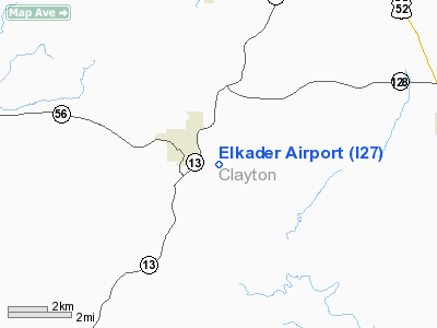
Elkader Airport
Address:
Clayton County, IA
Tel:
563-245-2899, 563-245-1594
Images
and information placed above are from
http://www.airport-data.com/airport/I27/
We
thank them for the data!
|
General Info |
| Country |
United
States |
| State |
IOWA
|
| FAA ID |
I27
|
| Latitude |
42-50-48.947N |
|
Longitude |
091-22-50.493W |
|
Elevation |
932 feet
|
| Near
City |
ELKADER
|
We don't guarantee the information is fresh and accurate. The data may
be wrong or outdated.
For more up-to-date information please refer to other sources.
|
|


