 |
|
|
|
|
|
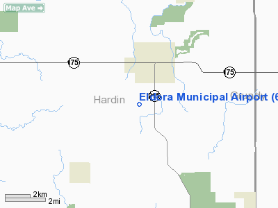
Location &
QuickFacts
|
FAA
Information Effective: |
2007-07-05 |
|
Airport
Identifier: |
6C0 |
|
Airport
Status: |
Operational |
|
Longitude/Latitude: |
093-06-50.5000W/42-19-50.4172N
-93.114028/42.330671 (Estimated) |
|
Elevation: |
979 ft / 298.40 m (Surveyed) |
|
Land: |
17 acres |
|
From
nearest city: |
2 nautical miles SW of Eldora, IA |
|
Location: |
Hardin County, IA |
|
Magnetic Variation: |
03E (1985) |
Owner & Manager
|
Ownership: |
Publicly owned |
|
Owner: |
City Of Eldora |
|
Address: |
1442 Washington
Eldora, IA 50627 |
|
Phone number: |
515-858-2393 |
|
Manager: |
Bob Jones |
|
Address: |
1442 Washington
Eldora, IA 50627 |
|
Phone number: |
515-858-3944 |
Airport
Operations and Facilities
|
Airport
Use: |
Open to public |
|
Wind
indicator: |
Yes |
|
Segmented Circle: |
No |
|
Control
Tower: |
No |
|
Landing
fee charge: |
No |
|
Sectional chart: |
Omaha |
|
Region: |
ACE - Central |
|
Boundary
ARTCC: |
ZAU - Chicago |
|
Tie-in
FSS: |
FOD - Fort Dodge |
|
FSS on
Airport: |
No |
|
FSS
Phone: |
515-955-8114 |
|
FSS Toll
Free: |
1-800-WX-BRIEF |
|
NOTAMs
Facility: |
FOD (NOTAM-d service avaliable) |
Airport Communications
Airport Services
|
Airframe
Repair: |
NONE |
|
Power
Plant Repair: |
NONE |
|
Bottled
Oxygen: |
NONE |
|
Bulk
Oxygen: |
NONE |
|
Runway Information
Runway 18/36
|
Dimension: |
2750 x 100 ft / 838.2 x 30.5 m |
|
Surface: |
TURF, Good Condition |
|
|
Runway 18
|
Runway 36
|
|
Elevation: |
979.00 ft |
0.00 ft |
|
Traffic
Pattern: |
Left |
Left |
|
Obstruction: |
69 ft , 1430.0 ft from runway, 85 ft left of centerline,
20:1 slope to clear |
41 ft trees, 875.0 ft from runway, 45 ft right of
centerline, 21:1 slope to clear |
|
Radio Navigation Aids
|
ID |
Type |
Name |
Ch |
Freq |
Var |
Dist |
|
IFA |
NDB |
Iowa Falls |
|
368.00 |
03E |
11.1 nm |
|
MIW |
NDB |
Marshalltown |
|
239.00 |
03E |
15.9 nm |
|
HPT |
NDB |
Hampton |
|
230.00 |
03E |
24.2 nm |
|
EBS |
NDB |
Webster City |
|
323.00 |
03E |
34.2 nm |
|
BNW |
NDB |
Boone |
|
407.00 |
03E |
36.9 nm |
|
CAV |
NDB |
Clarion |
|
387.00 |
03E |
37.9 nm |
|
GGI |
NDB |
Grinnell |
|
248.00 |
02E |
41.1 nm |
|
EAG |
NDB |
Eagle Grove |
|
302.00 |
03E |
42.0 nm |
|
IKV |
NDB |
Ankeny |
|
275.00 |
03E |
43.0 nm |
|
TZT |
NDB |
Belle Plaine |
|
371.00 |
02E |
45.7 nm |
|
VTI |
NDB |
Garrison |
|
338.00 |
03E |
49.1 nm |
|
CCY |
NDB |
Charles City |
|
375.00 |
03E |
49.7 nm |
|
JWJ |
VOR/DME |
Elmwood |
031X |
109.40 |
03E |
16.0 nm |
|
TNU |
VOR/DME |
Newton |
072X |
112.50 |
03E |
32.9 nm |
|
ALO |
VORTAC |
Waterloo |
059X |
112.20 |
06E |
34.5 nm |
|
MCW |
VORTAC |
Mason City |
096X |
114.90 |
06E |
46.9 nm |
Remarks
-
ARPT CLSD SS-SR.
-
ARPT CLSD NOV-APR.
-
ULTRALIGHT ACTIVITY
PROHIBITED.
-
EXISTED PRIOR TO 10/01/59.
Based Aircraft
|
Aircraft based
on field: |
2 |
|
Single Engine
Airplanes: |
2 |
Operational Statistics
Time Period:
2005-09-13 -
2006-09-12
|
Aircraft
Operations: |
10/Week |
|
General
Aviation Local: |
39.9% |
|
General
Aviation Itinerant: |
60.1% |
Eldora Municipal Airport
Address:
Hardin County, IA
Tel:
515-858-2393, 515-858-3944
Images
and information placed above are from
http://www.airport-data.com/airport/6C0/
We
thank them for the data!
|
General Info |
| Country |
United
States |
| State |
IOWA
|
| FAA ID |
6C0
|
| Latitude |
42-19-47.940N |
|
Longitude |
093-06-59.728W |
|
Elevation |
979 feet
|
| Near
City |
ELDORA
|
We don't guarantee the information is fresh and accurate. The data may
be wrong or outdated.
For more up-to-date information please refer to other sources.
|
|


