 |
|
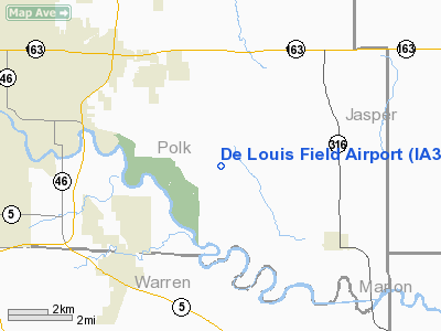
Location &
QuickFacts
|
FAA
Information Effective: |
2007-07-05 |
|
Airport
Identifier: |
IA38 |
|
Airport
Status: |
Operational |
|
Longitude/Latitude: |
093-25-45.0000W/41-32-53.0000N
-93.429167/41.548056 (Estimated) |
|
Elevation: |
1250 ft / 381.00 m (Estimated) |
|
Land: |
0 acres |
|
From
nearest city: |
10 nautical miles E of Des Moines, IA |
|
Location: |
Polk County, IA |
|
Magnetic Variation: |
04E (1990) |
Owner & Manager
|
Ownership: |
Privately owned |
|
Owner: |
Frank De Louis |
|
Address: |
8797 Se 32 Ave
Runnells, IA 50237 |
|
Phone number: |
515-966-2307 |
|
Manager: |
Frank De Louis |
|
Address: |
8797 Se 32 Ave
Runnells, IA 50237 |
|
Phone number: |
515-966-2307 |
Airport
Operations and Facilities
|
Airport
Use: |
Private |
|
Segmented Circle: |
No |
|
Control
Tower: |
No |
|
Sectional chart: |
Omaha |
|
Region: |
ACE - Central |
|
Boundary
ARTCC: |
ZAU - Chicago |
|
Tie-in
FSS: |
FOD - Fort Dodge |
|
FSS
Phone: |
515-955-8114 |
|
FSS Toll
Free: |
1-800-WX-BRIEF |
|
Runway Information
Runway 18/36
|
Dimension: |
1700 x 200 ft / 518.2 x 61.0 m |
|
Surface: |
TURF, |
|
|
Runway 18
|
Runway 36
|
|
Traffic
Pattern: |
Left |
Left |
|
Radio Navigation Aids
|
ID |
Type |
Name |
Ch |
Freq |
Var |
Dist |
|
IKV |
NDB |
Ankeny |
|
275.00 |
03E |
10.9 nm |
|
OXV |
NDB |
Knoxville |
|
284.00 |
03E |
20.8 nm |
|
PEA |
NDB |
Pella |
|
257.00 |
02E |
23.5 nm |
|
CNC |
NDB |
Chariton |
|
335.00 |
05E |
32.1 nm |
|
GGI |
NDB |
Grinnell |
|
248.00 |
02E |
32.9 nm |
|
BNW |
NDB |
Boone |
|
407.00 |
03E |
35.9 nm |
|
PRO |
NDB |
Perry |
|
251.00 |
06E |
37.0 nm |
|
MIW |
NDB |
Marshalltown |
|
239.00 |
03E |
40.8 nm |
|
GCT |
NDB |
Guthrie Center |
|
518.00 |
05E |
45.8 nm |
|
OOA |
NDB |
Oskaloosa |
|
414.00 |
03E |
46.7 nm |
|
GFZ |
NDB |
Greenfield |
|
338.00 |
04E |
47.7 nm |
|
EFW |
NDB |
Jefferson |
|
391.00 |
03E |
49.6 nm |
|
TNU |
VOR/DME |
Newton |
072X |
112.50 |
03E |
20.2 nm |
|
JWJ |
VOR/DME |
Elmwood |
031X |
109.40 |
03E |
41.1 nm |
|
DSM |
VORTAC |
Des Moines |
122X |
117.50 |
07E |
11.9 nm |
|
DSM |
VOT |
Des Moines |
|
109.20 |
|
11.0 nm |
Remarks
-
PRVDD APCH TO
EACH RY MAINTAINED FOR A MINIMUM 20:1 GLIDE SLOPE; TRANSITIONAL SURFACE BE
MAINTAINED FOR A 7:1.
Based
Aircraft
|
Aircraft based
on field: |
1 |
|
Single Engine
Airplanes: |
1 |
De Louis Field Airport
Address:
Polk County, IA
Tel:
515-966-2307
Images
and information placed above are from
http://www.airport-data.com/airport/IA38/
We
thank them for the data!
|
General Info |
| Country |
United
States |
| State |
IOWA
|
| FAA ID |
IA38
|
| Latitude |
41-32-53.000N |
|
Longitude |
093-25-45.000W |
|
Elevation |
1250
feet |
| Near
City |
DES
MOINES |
We don't guarantee the information is fresh and accurate. The data may
be wrong or outdated.
For more up-to-date information please refer to other sources.
|
|


