 |
|
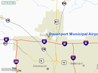
Davenport Municipal Airport |
Coordinates: 41°36â²37â³N 090°35â²18â³W / 41.61028°N 90.58833°W / 41.61028; -90.58833
| Davenport Municipal Airport |
| IATA: DVN â ICAO: KDVN â FAA LID: DVN
Location of Davenport Municipal Airport
|
| Summary |
| Airport type |
Public |
| Owner |
City of Davenport |
| Serves |
Davenport, Iowa |
| Elevation AMSL |
753 ft / 230 m |
| Website |
CityOfDavenportIowa.com/... |
| Runways |
| Direction |
Length |
Surface |
| ft |
m |
| 15/33 |
5,500 |
1,677 |
Concrete |
| 3/21 |
4,000 |
1,220 |
Concrete |
| Statistics (2007) |
| Aircraft operations |
28,251 |
| Based aircraft |
108 |
| Source: Federal Aviation Administration |
Davenport Municipal Airport (IATA: DVN, ICAO: KDVN, FAA LID: DVN) is a general aviation airport located about 7 miles (11 km) north of downtown Davenport, a city in Scott County, Iowa, United States. The airport, which dates back from 1948, has also been home to the Quad City Air Show since 1987. The air show occurs the last weekend of June every year.
The fixed base operation is run by Carver Aero Inc. The airport has two runways (3-21 and 15-33) and a 12,000-square-foot (1,100 m) hangar. Most of the air traffic in and out of Davenport Municipal is regional, consisting mainly of single-prop and twin-prop aircraft. However, some smaller private jets also utilize the airport for longer trips to other destinations around the United States. The National Oceanic and Atmospheric Administration operates the Quad Cities National Weather Service office from Davenport Municipal Airport. Also the U.S. Army Iowa National Guard 1/109th Aviation Battalion Maintains an Armory with 3-4 CH-47 Chinook Helicopters. Facilities and aircraft
Davenport Municipal Airport covers an area of 764 acres (309 ha) which contains two concrete paved runways: 15/33 measuring 5,500 x 100 ft (1,677 x 30 m) and 3/21 measuring 4,000 x 100 ft (1,220 x 30 m).
For the 12-month period ending May 23, 2007, the airport had 28,251 aircraft operations, an average of 77 per day: 94% general aviation, 4% air taxi and 2% military. There are 108 aircraft based at this airport: 72% single-engine, 14% multi-engine, 2% jet, 1% helicopter and 11% military.
Quad City Airshow
The Quad City Airshow has been hosted at the Davenport Municipal Airport since 1987. The show has hosted all of the North American Military Demonstration Teams, and several International performers. This years Quad City Airshow will be held on June 26â27 and will be a tribute to all US Military Veterans. The 2011 Quad City Airshow will be host to the U.S. Navy Blue Angels as part of their 100 Years of Naval Aviation Tour, the show will take place June 18â19, 2011.
- Headline Performers
1987: None
1988: None
1989: U.S. Navy Blue Angels
1990: None
June 1991: None
September 1991: Snowbirds
1992: U.S. Navy Blue Angels
1993: U.S. Air Force Thunderbirds
1994: U.S. Navy Blue Angels
1995: U.S. Air Force Thunderbirds
1996: U.S. Navy Blue Angels
1997: None
1998: U.S. Air Force Thunderbirds
1999: U.S. Navy Blue Angels
2000: U.S. Air Force Thunderbirds
2001: U.S. Navy Blue Angels
2002: U.S. Air Force Thunderbirds & Canadian Snowbirds
2003: U.S. Navy Blue Angels
2004: Masters of Disaster
2005: U.S. Air Force Thunderbirds
2006: U.S. Navy Blue Angels
2007: U.S. Air Force Thunderbirds
2008: U.S. Navy Blue Angels
2009: U.S. Navy Blue Angels
2010: Tora! Tora! Tora!
2011: U.S. Navy Blue Angels
The above content comes from Wikipedia and is published under free licenses – click here to read more.
|
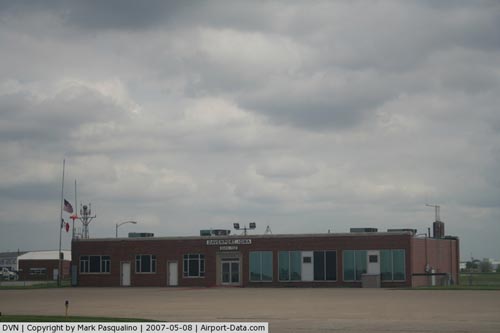 |
(Click on the photo to enlarge) |
Location &
QuickFacts
|
FAA
Information Effective: |
2007-07-05 |
|
Airport
Identifier: |
DVN |
|
Airport
Status: |
Operational |
|
Longitude/Latitude: |
090-35-17.9710W/41-36-36.9990N
-90.588325/41.610278 (Estimated) |
|
Elevation: |
753 ft / 229.51 m (Surveyed) |
|
Land: |
764 acres |
|
From
nearest city: |
5 nautical miles N of Davenport, IA |
|
Location: |
Scott County, IA |
|
Magnetic Variation: |
01E (1985) |
Owner & Manager
|
Ownership: |
Publicly owned |
|
Owner: |
City Of Davenport |
|
Address: |
City Hall 226 W 4th St
Davenport, IA 52801 |
|
Phone
number: |
563-326-7783 |
|
Manager: |
Sandra Barrett
BYRON BAXTER, AIRPORT PLANNER 563-326-7783(OFC). |
|
Address: |
9230 Harrison St
Davenport, IA 52804 |
|
Phone number: |
563-391-5650 |
Airport
Operations and Facilities
|
Airport
Use: |
Open to public |
|
Wind
indicator: |
Yes |
|
Segmented Circle: |
No |
|
Control
Tower: |
No |
|
Lighting
Schedule: |
DUSK-DAWN
ACTVT MIRL RYS 03/21; 15/33; VASI RYS 15; 33; MALSR RY 15 & REIL RY 33
- CTAF. |
|
Beacon
Color: |
Clear-Green (lighted land airport) |
|
Landing
fee charge: |
No |
|
Sectional chart: |
Chicago |
|
Region: |
ACE - Central |
|
Boundary
ARTCC: |
ZAU - Chicago |
|
Tie-in
FSS: |
FOD - Fort Dodge |
|
FSS on
Airport: |
No |
|
FSS
Phone: |
515-955-8114 |
|
FSS Toll
Free: |
1-800-WX-BRIEF |
|
NOTAMs
Facility: |
DVN (NOTAM-d service avaliable) |
|
Federal Agreements: |
NGY |
Airport Communications
|
CTAF: |
123.000 |
|
Unicom: |
123.000 |
Airport Services
|
Fuel
available: |
100LLA |
|
Airframe
Repair: |
MAJOR |
|
Power
Plant Repair: |
MAJOR |
|
Bottled
Oxygen: |
NONE |
|
Bulk
Oxygen: |
NONE |
|
Runway Information
Runway 03/21
|
Dimension: |
4001 x 100 ft / 1219.5 x 30.5 m |
|
Surface: |
CONC, Good Condition |
|
Weight Limit: |
Single wheel: 68000 lbs.
Dual wheel: 93000 lbs.
Dual tandem wheel: 122000 lbs. |
|
Edge Lights: |
Non-standard lighting system
NSTD MIRL, THLDS HAVE ONLY 6 LGTS; CLEAR LENSES ENTIRE RY LENGTH. |
|
|
Runway 03
|
Runway 21
|
|
Longitude: |
090-35-31.0760W |
090-35-05.0830W |
|
Latitude: |
41-36-26.8510N |
41-37-01.2250N |
|
Elevation: |
747.00 ft |
749.00 ft |
|
Alignment: |
30 |
127 |
|
Traffic
Pattern: |
Left |
Left |
|
Markings: |
Non-precision instrument, Fair Condition |
Non-precision instrument, Fair Condition |
|
Crossing
Height: |
44.00 ft |
44.00 ft |
|
VASI: |
4-box on left side |
4-box on left side |
|
Visual
Glide Angle: |
3.00° |
3.00° |
|
Obstruction: |
, 50:1 slope to clear |
14 ft road, 500.0 ft from runway, 21:1 slope to clear |
|
Runway 15/33
|
Dimension: |
5501 x 100 ft / 1676.7 x 30.5 m |
|
Surface: |
CONC, Good Condition |
|
Weight Limit: |
Single wheel: 68000 lbs.
Dual wheel: 93000 lbs.
Dual tandem wheel: 122000 lbs. |
|
Edge Lights: |
Medium
NSTD MIRL, THLDS HAVE ONLY 6 LGTS; CLEAR LENSES ENTIRE RY LENGTH. |
|
|
Runway 15
|
Runway 33
|
|
Longitude: |
090-35-36.2330W |
090-34-59.5500W |
|
Latitude: |
41-36-55.3080N |
41-36-08.4500N |
|
Elevation: |
753.00 ft |
743.00 ft |
|
Alignment: |
127 |
127 |
|
ILS Type: |
ILS/DME |
|
|
Traffic
Pattern: |
Left |
Left |
|
Markings: |
Precision instrument, Fair Condition |
Non-precision instrument, Fair Condition |
|
Crossing
Height: |
39.00 ft |
48.00 ft |
|
VASI: |
4-box on left side |
4-box on left side |
|
Visual
Glide Angle: |
3.00° |
3.00° |
|
Approach
lights: |
MALSR |
|
|
Runway End
Identifier: |
|
Yes |
|
Obstruction: |
18 ft road, 980.0 ft from runway, 43:1 slope to clear |
, 50:1 slope to clear |
|
Radio Navigation Aids
|
ID |
Type |
Name |
Ch |
Freq |
Var |
Dist |
|
CWI |
NDB |
Clinton |
|
377.00 |
01E |
17.6 nm |
|
OQW |
NDB |
Maquoketa |
|
386.00 |
02E |
27.4 nm |
|
BOZ |
NDB |
Whiteside |
|
254.00 |
01E |
36.6 nm |
|
EZI |
NDB |
Kewanee |
|
245.00 |
01E |
37.5 nm |
|
MXO |
NDB |
Monticello |
|
397.00 |
01E |
43.1 nm |
|
DDD |
VOR/DME |
Port City |
112X |
116.50 |
01E |
29.2 nm |
|
GBG |
VOR/DME |
Galesburg |
035X |
109.80 |
03E |
41.0 nm |
|
CVA |
VORTAC |
Davenport |
085X |
113.80 |
04E |
7.6 nm |
|
MZV |
VORTAC |
Moline |
091X |
114.40 |
05E |
17.5 nm |
|
IOW |
VORTAC |
Iowa City |
109X |
116.20 |
05E |
46.4 nm |
|
DBQ |
VORTAC |
Dubuque |
105X |
115.80 |
04E |
47.9 nm |
|
DVN |
VOT |
Davenport Municipal |
|
111.80 |
|
0.1 nm |
Remarks
-
HELICOPTER
OPERATIONS ON CTAF OPERG PARALLEL TO RYS FM GRASS AREAS.
-
RWY 15 DESIGNATED
CALM WIND RY.
-
TWO WAY RADIO
COMMUNICATIONS REQUIRED FOR ALL ACFT CONDUCTING MULTIPLE OPNS.
-
EXTSV HVY MIL HEL
(CHINOOK) TRNG ON & INVOF OF ARPT; PSBL EXTREME TRUB FM ROTORS.
-
ULTRALIGHT ACTIVITY
PROHIBITED.
-
ARNG: DSN 431-5510.
Based Aircraft
|
Aircraft based
on field: |
108 |
|
Single Engine
Airplanes: |
78 |
|
Multi Engine
Airplanes: |
15 |
|
Jet Engine
Airplanes: |
2 |
|
Helicopters: |
1 |
|
Military: |
12 |
Operational Statistics
Time Period:
2006-05-24 -
2007-05-23
|
Aircraft
Operations: |
78/Day |
|
Air Taxi: |
3.6% |
|
General
Aviation Local: |
43.0% |
|
General
Aviation Itinerant: |
51.6% |
|
Military: |
1.8% |
Davenport Municipal Airport
Address:
Scott County, IA
Tel:
563-326-7783,
563-391-5650
Images
and information placed above are from
http://www.airport-data.com/airport/DVN/
We
thank them for the data!
|
General Info |
| Country |
United
States |
| State |
IOWA
|
| FAA ID |
DVN
|
| Latitude |
41-36-36.999N |
|
Longitude |
090-35-17.971W |
|
Elevation |
753 feet
|
| Near
City |
DAVENPORT |
We don't guarantee the information is fresh and accurate. The data may
be wrong or outdated.
For more up-to-date information please refer to other sources.
|
|


