 |
|
|
|
|
|
Location &
QuickFacts
|
FAA
Information Effective: |
2007-07-05 |
|
Airport
Identifier: |
Y16 |
|
Airport
Status: |
Operational |
|
Longitude/Latitude: |
091-36-54.5340W/43-04-43.9240N
-91.615148/43.078868 (Estimated) |
|
Elevation: |
1200 ft / 365.76 m (Estimated) |
|
Land: |
5 acres |
|
From
nearest city: |
2 nautical miles SW of Postville, IA |
|
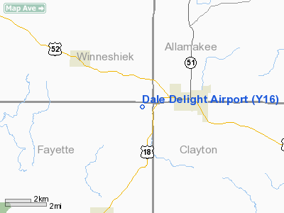
Location: |
Fayette County, IA |
|
Magnetic Variation: |
02E (1985) |
Owner & Manager
|
Ownership: |
Privately owned |
|
Owner: |
C. Keith Kerr |
|
Address: |
Rfd 2, Box 40
Postville, IA 52162 |
|
Phone number: |
563-864-3256 |
|
Manager: |
C. Keith Kerr |
|
Address: |
Rfd 2, Box 40
Postville, IA 52162 |
|
Phone number: |
563-864-3256 |
Airport
Operations and Facilities
|
Airport
Use: |
Open to public |
|
Wind
indicator: |
Yes |
|
Segmented Circle: |
No |
|
Control
Tower: |
No |
|
Landing
fee charge: |
No |
|
Sectional chart: |
Chicago |
|
Region: |
ACE - Central |
|
Boundary
ARTCC: |
ZMP - Minneapolis |
|
Tie-in
FSS: |
FOD - Fort Dodge |
|
FSS on
Airport: |
No |
|
FSS
Phone: |
515-955-8114 |
|
FSS Toll
Free: |
1-800-WX-BRIEF |
|
NOTAMs
Facility: |
FOD (NOTAM-d service avaliable) |
Airport Communications
Airport Services
|
Airframe
Repair: |
NONE |
|
Power
Plant Repair: |
NONE |
|
Runway Information
Runway 11/29
|
Dimension: |
2325 x 70 ft / 708.7 x 21.3 m |
|
Surface: |
TURF, Good Condition |
|
|
Runway 11
|
Runway 29
|
|
Traffic
Pattern: |
Left |
Left |
|
Obstruction: |
, 50:1 slope to clear |
15 ft road, 350.0 ft from runway, 23:1 slope to clear |
|
Radio Navigation Aids
|
ID |
Type |
Name |
Ch |
Freq |
Var |
Dist |
|
XWY |
NDB |
West Union |
|
278.00 |
02E |
10.9 nm |
|
DEH |
NDB |
Decorah |
|
236.00 |
01E |
13.0 nm |
|
CJJ |
NDB |
Cresco |
|
293.00 |
02E |
28.4 nm |
|
OLZ |
NDB |
Oelwein |
|
260.00 |
02E |
28.6 nm |
|
CHU |
NDB |
Caledonia |
|
209.00 |
03E |
31.0 nm |
|
IIB |
NDB |
Wapsie |
|
206.00 |
02E |
40.5 nm |
|
CCY |
NDB |
Charles City |
|
375.00 |
03E |
43.6 nm |
|
IY |
NDB |
Chukk |
|
417.00 |
03E |
49.0 nm |
|
UKN |
VORTAC |
Waukon |
113X |
116.60 |
05E |
12.6 nm |
|
ALO |
VORTAC |
Waterloo |
059X |
112.20 |
06E |
46.7 nm |
Remarks
-
NO SNOW REMOVAL -
CALL 563-864-3256 FOR ARPT CONDITIONS.
-
ABRUPT DROP OFF
AT RY 11 THR.
-
PROVIDED THE
APPROACH TO EACH RWY IS MAINTAINED FOR A MINIMUM 20:1 GLIDE SLOPE AND THE
TRANSITIONAL SURFACE BE MAINTAINED FOR A 7:1 SLOPE.
Based
Aircraft
|
Aircraft based
on field: |
1 |
|
Single Engine
Airplanes: |
1 |
Operational Statistics
Time Period:
2001-07-10 -
2002-07-09
|
Aircraft
Operations: |
11/Month |
|
General
Aviation Local: |
80.6% |
|
General
Aviation Itinerant: |
19.4% |
Dale Delight Airport
Address:
Fayette County, IA
Tel:
563-864-3256
Images
and information placed above are from
http://www.airport-data.com/airport/Y16/
We
thank them for the data!
|
General Info |
| Country |
United
States |
| State |
IOWA
|
| FAA ID |
Y16
|
| Latitude |
43-04-43.924N |
|
Longitude |
091-36-54.534W |
|
Elevation |
1200
feet |
| Near
City |
POSTVILLE |
We don't guarantee the information is fresh and accurate. The data may
be wrong or outdated.
For more up-to-date information please refer to other sources.
|
|


