 |
|
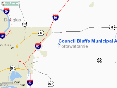
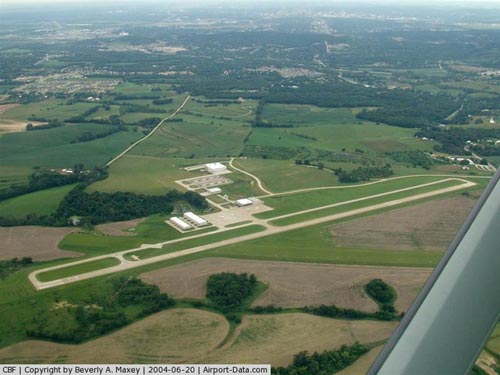
Council Bluffs Municipal Airport |
| Council Bluffs Municipal Airport |
| IATA: CBF â ICAO: KCBF â FAA LID: CBF |
| Summary |
| Airport type |
Public |
| Operator |
Council Bluffs Airport Authority |
| Serves |
Council Bluffs, Iowa |
| Elevation AMSL |
1,253 ft / 382 m |
| Coordinates |
41°15â²37â³N 095°45â²32â³W / 41.26028°N 95.75889°W / 41.26028; -95.75889 |
| Website |
www.cbairport.com |
| Runways |
| Direction |
Length |
Surface |
| ft |
m |
| 18/36 |
5,500 |
1,676 |
Concrete |
| 14/32 |
3,650 |
1,113 |
Concrete |
Council Bluffs Municipal Airport (IATA: CBF, ICAO: KCBF, FAA LID: CBF) is a general aviation airport located 4 miles east of Council Bluffs, Iowa, United States. Flight School and Air Charter Company, Advanced Air Inc. operates out of this airport. The airport is also the site of Iowa Western Community College's Aviation Maintenance Technology program, and their Professional Pilot training program.
Runway 36 is also expected to have ILS approach system capabilities sometimes in the near future. While the hardware has been installed already, the system is not yet operational.
The above content comes from Wikipedia and is published under free licenses – click here to read more.
|
 |
(Click on the photo to enlarge) |
Location &
QuickFacts
|
FAA
Information Effective: |
2007-07-05 |
|
Airport
Identifier: |
CBF |
|
Airport
Status: |
Operational |
|
Longitude/Latitude: |
095-45-32.9150W/41-15-40.0470N
-95.759143/41.261124 (Estimated) |
|
Elevation: |
1253 ft / 381.91 m (Surveyed) |
|
Land: |
656 acres |
|
From
nearest city: |
4 nautical miles E of Council Bluffs, IA |
|
Location: |
Pottawattamie County, IA |
|
Magnetic Variation: |
05E (2000) |
Owner & Manager
|
Ownership: |
Publicly owned |
|
Owner: |
Council Bluffs Airport Authority |
|
Address: |
Council Bluffs, IA 51501 |
|
Phone
number: |
712-322-2284 |
|
Manager: |
Dan Smith |
|
Address: |
16801 Mccandles Lane Suite #2
Council Bluffs, IA 51503 |
|
Phone number: |
402-630-2851 |
Airport Operations and Facilities
|
Airport
Use: |
Open to public |
|
Wind
indicator: |
Yes |
|
Segmented Circle: |
No |
|
Control
Tower: |
No |
|
Lighting
Schedule: |
DUSK-DAWN
ACTVT MIRL RYS 14/32 & 18/36; VASI RY 14 & PAPI RYS 18, 32 & 36; REIL
RYS 14, 32 & 18 - CTAF. |
|
Beacon
Color: |
Clear-Green (lighted land airport) |
|
Landing
fee charge: |
No |
|
Sectional chart: |
Omaha |
|
Region: |
ACE - Central |
|
Boundary
ARTCC: |
ZMP - Minneapolis |
|
Tie-in
FSS: |
FOD - Fort Dodge |
|
FSS on
Airport: |
No |
|
FSS
Phone: |
515-955-8114 |
|
FSS Toll
Free: |
1-800-WX-BRIEF |
|
NOTAMs
Facility: |
CBF (NOTAM-d service avaliable) |
|
Federal Agreements: |
NGY |
Airport Communications
|
CTAF: |
122.800 |
|
Unicom: |
122.800 |
Airport Services
|
Fuel
available: |
100LLA |
|
Airframe
Repair: |
MAJOR
PROP REPAIRS AVBL. |
|
Power
Plant Repair: |
MAJOR |
|
Bottled
Oxygen: |
LOW |
|
Bulk
Oxygen: |
NONE |
|
Runway Information
Runway 14/32
|
Dimension: |
4100 x 75 ft / 1249.7 x 22.9 m |
|
Surface: |
CONC, Good Condition |
|
Weight Limit: |
Single wheel: 28000 lbs.
Dual wheel: 48000 lbs. |
|
Edge Lights: |
Medium |
|
|
Runway 14
|
Runway 32
|
|
Longitude: |
095-45-55.1390W |
095-45-21.3410W |
|
Latitude: |
41-15-48.7430N |
41-15-17.2680N |
|
Elevation: |
1232.00 ft |
1244.00 ft |
|
Alignment: |
127 |
127 |
|
Traffic
Pattern: |
Left |
Left |
|
Markings: |
Non-precision instrument, Fair Condition |
Non-precision instrument, Good Condition |
|
Crossing
Height: |
52.00 ft |
44.00 ft |
|
VASI: |
2-box on left side |
4-light PAPI on left side
PAPI OTS INDEFLY. |
|
Visual
Glide Angle: |
3.00° |
3.00° |
|
Runway End
Identifier: |
Yes |
Yes |
|
Obstruction: |
23 ft trees, 597.0 ft from runway, 171 ft left of
centerline, 17:1 slope to clear |
, 0.0 ft from runway, 50:1 slope to clear |
|
Runway 18/36
|
Dimension: |
5500 x 100 ft / 1676.4 x 30.5 m |
|
Surface: |
CONC, |
|
Weight Limit: |
Single wheel: 30000 lbs.
Dual wheel: 60000 lbs. |
|
Edge Lights: |
Medium |
|
|
Runway 18
|
Runway 36
|
|
Longitude: |
095-45-26.7600W |
095-45-28.6725W |
|
Latitude: |
41-16-07.0190N |
41-15-12.6973N |
|
Alignment: |
127 |
1 |
|
Traffic
Pattern: |
Left |
Left |
|
Markings: |
Non-precision instrument, Good Condition |
Non-precision instrument, Good Condition |
|
Crossing
Height: |
45.00 ft |
0.00 ft |
|
VASI: |
2-light PAPI on left side |
4-light PAPI on left side |
|
Visual
Glide Angle: |
3.00° |
0.00° |
|
Runway End
Identifier: |
Yes |
|
|
Obstruction: |
, 5 ft right of centerline |
28 ft gnd, 400.0 ft from runway, 7:1 slope to clear |
|
Radio Navigation Aids
|
ID |
Type |
Name |
Ch |
Freq |
Var |
Dist |
|
OM |
NDB |
Gerfi |
|
320.00 |
05E |
10.9 nm |
|
MLE |
NDB |
Millard |
|
371.00 |
06E |
16.5 nm |
|
PMV |
NDB |
Plattsmouth |
|
329.00 |
06E |
20.3 nm |
|
HNR |
NDB |
Harlan |
|
272.00 |
05E |
26.9 nm |
|
RDK |
NDB |
Red Oak |
|
230.00 |
04E |
27.2 nm |
|
AIO |
NDB |
Atlantic |
|
365.00 |
04E |
33.3 nm |
|
SDA |
NDB |
Shenandoah |
|
411.00 |
05E |
34.5 nm |
|
FET |
NDB |
Fremont |
|
311.00 |
06E |
36.1 nm |
|
AHQ |
NDB |
Wahoo |
|
400.00 |
07E |
37.9 nm |
|
AFK |
NDB |
Nebraska City |
|
347.00 |
05E |
39.7 nm |
|
ADU |
NDB |
Audubon |
|
266.00 |
04E |
46.1 nm |
|
ICL |
NDB |
Clarinda |
|
353.00 |
04E |
46.2 nm |
|
DNS |
NDB |
Denison |
|
350.00 |
04E |
46.7 nm |
|
CRZ |
NDB |
Corning |
|
278.00 |
04E |
48.1 nm |
|
AYB |
NDB |
Auburn |
|
430.00 |
05E |
49.7 nm |
|
OFF |
TACAN |
Offutt |
054X |
|
05E |
10.7 nm |
|
TQE |
VOR |
Tekamah |
|
108.40 |
07E |
35.4 nm |
|
SCB |
VOR/DME |
Scribner |
47X |
111.00 |
06E |
44.3 nm |
|
OVR |
VORTAC |
Omaha |
110X |
116.30 |
08E |
5.7 nm |
|
LNK |
VORTAC |
Lincoln |
108X |
116.10 |
09E |
48.9 nm |
|
OMA |
VOT |
Omaha |
|
109.00 |
|
6.1 nm |
Remarks
-
DEER ON & INVOF ARPT.
-
TWY 'A' CLSD
NORTH OF A2 INTERSECTION & SOUTH OF A3 INTERSECTION.
Based
Aircraft
|
Aircraft based
on field: |
91 |
|
Single Engine
Airplanes: |
64 |
|
Multi Engine
Airplanes: |
14 |
|
Jet Engine
Airplanes: |
3 |
|
Helicopters: |
10 |
Operational Statistics
Time Period:
2004-11-09 -
2005-11-08
|
Aircraft
Operations: |
106/Day |
|
Air Taxi: |
0.5% |
|
General
Aviation Local: |
49.5% |
|
General
Aviation Itinerant: |
49.5% |
|
Military: |
0.5% |
Council Bluffs Municipal Airport
Address:
Pottawattamie County, IA
Tel:
712-322-2284,
402-630-2851
Images
and information placed above are from
http://www.airport-data.com/airport/CBF/
We
thank them for the data!
|
General Info |
| Country |
United
States |
| State |
IOWA
|
| FAA ID |
CBF
|
| Latitude |
41-15-34.100N |
|
Longitude |
095-45-35.900W |
|
Elevation |
1253
feet |
| Near
City |
COUNCIL
BLUFFS |
We don't guarantee the information is fresh and accurate. The data may
be wrong or outdated.
For more up-to-date information please refer to other sources.
|
|


