 |
|
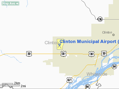
Clinton Municipal Airport |
| Clinton Municipal Airport |
 |
| USGS aerial image, 1994 (North is to the right) |
| IATA: CWI â ICAO: KCWI â FAA LID: CWI |
| Summary |
| Airport type |
Public |
| Owner |
City of Clinton |
| Serves |
Clinton, Iowa |
| Elevation AMSL |
708 ft / 216 m |
| Coordinates |
41°49â²52â³N 090°19â²45â³W / 41.83111°N 90.32917°W / 41.83111; -90.32917 |
| Website |
www.clintonairport.us |
| Runways |
| Direction |
Length |
Surface |
| ft |
m |
| 3/21 |
5,204 |
1,586 |
Asphalt |
| 14/32 |
3,700 |
1,128 |
Asphalt |
| Statistics (2009) |
| Aircraft operations |
15,400 |
| Based aircraft |
40 |
| Source: Federal Aviation Administration |
Clinton Municipal Airport (IATA: CWI, ICAO: KCWI, FAA LID: CWI) is a city-owned public-use airport located six nautical miles (11 km) southwest of the central business district of Clinton, a city in Clinton County, Iowa, United States. This airport is included in the FAA's National Plan of Integrated Airport Systems (2009-2013), which categorizes it as a general aviation airport.
Facilities and aircraft
Clinton Municipal Airport covers an area of 357 acres (144 ha) at an elevation of 708 feet (216 m) above mean sea level. It has two asphalt paved runways: 3/21 is 5,204 by 100 feet (1,586 x 30 m) and 14/32 is 3,700 by 100 feet (1,128 x 30 m).
For the 12-month period ending May 28, 2009, the airport had 15,400 aircraft operations, an average of 42 per day: 95% general aviation, 3% military and 2% air taxi, At that time there were 40 aircraft based at this airport: 77.5% single-engine, 5% multi-engine, 2.5% helicopter and 15% ultralight.
The above content comes from Wikipedia and is published under free licenses – click here to read more.
Location
& QuickFacts
|
FAA Information Effective: |
2007-07-05 |
|
Airport
Identifier: |
CWI |
|
Airport
Status: |
Operational |
|
Longitude/Latitude: |
090-19-44.9000W/41-49-52.0000N
-90.329139/41.831111 (Estimated) |
|
Elevation: |
708 ft / 215.80 m (Surveyed) |
|
Land: |
357 acres |
|
From
nearest city: |
6 nautical miles SW of Clinton, IA |
|
Location: |
Clinton County, IA |
|
Magnetic Variation: |
00E (2000) |
Owner
& Manager
|
Ownership: |
Publicly owned |
|
Owner: |
City Of Clinton
CHMN ARPT CMSN:RANDY CLEGG; 563-243-9600. |
|
Address: |
City Hall
Clinton, IA 52732 |
|
Phone
number: |
563-242-2144 |
|
Manager: |
Michael Nass |
|
Address: |
2000 S 60th St.
Clinton, IA 52732 |
|
Phone number: |
563-242-3292 |
Airport
Operations and Facilities
|
Airport Use: |
Open to public |
|
Wind
indicator: |
Yes |
|
Segmented
Circle: |
No |
|
Control
Tower: |
No |
|
Lighting
Schedule: |
DUSK-DAWN
ACTVT HIRL RY 03/21 & MIRL RY 14/32; MALSR RY 03; VASI
RYS 14; 21 & 32 & REIL RYS 14 & 21 - 118.5. |
|
Beacon
Color: |
Clear-Green (lighted land airport) |
|
Landing
fee charge: |
No |
|
Sectional
chart: |
Chicago |
|
Region: |
ACE - Central |
|
Boundary
ARTCC: |
ZAU - Chicago |
|
Tie-in
FSS: |
FOD - Fort Dodge |
|
FSS
on Airport: |
No |
|
FSS
Phone: |
515-955-8114 |
|
FSS
Toll Free: |
1-800-WX-BRIEF |
|
NOTAMs
Facility: |
CWI (NOTAM-d service avaliable) |
|
Federal Agreements: |
NGY |
Airport
Communications
|
CTAF: |
122.800 |
|
Unicom: |
122.800 |
Airport
Services
|
Fuel available: |
100LLA |
|
Bottled
Oxygen: |
NONE |
|
Bulk
Oxygen: |
NONE |
|
Runway Information
Runway 03/21
|
Dimension: |
5204 x 100 ft / 1586.2 x 30.5 m |
|
Surface: |
ASPH, Fair Condition |
|
Weight
Limit: |
Single wheel: 37000 lbs.
Dual wheel: 48000 lbs. |
|
Edge
Lights: |
High |
|
|
Runway 03 |
Runway 21 |
|
Longitude: |
090-19-58.9121W |
090-19-24.8884W |
|
Latitude: |
41-49-34.8109N |
41-50-19.4868N |
|
Elevation: |
691.00 ft |
707.00 ft |
|
Alignment: |
30 |
127 |
|
ILS
Type: |
ILS/DME |
|
|
Traffic
Pattern: |
Left |
Left |
|
Markings: |
Precision instrument, Good Condition |
Precision instrument, Good Condition |
|
Crossing
Height: |
0.00 ft |
34.00 ft |
|
VASI: |
|
4-box on left side |
|
Visual
Glide Angle: |
0.00° |
3.00° |
|
Approach
lights: |
MALSR |
|
|
Runway
End Identifier: |
|
Yes |
|
Obstruction: |
14 ft road, 400.0 ft from runway, 500 ft left
of centerline, 14:1 slope to clear |
, 50:1 slope to clear
HIGH GND 200' FM THR; 275' RIGHT OF CNTRLN. |
|
Decleard
distances: |
Take off run available 5204.00 ft
Take off distance available 5204.00 ft
Actual stop distance available 5204.00 ft
Landing distance available 5204.00 ft |
Take off run available 5204.00 ft
Take off distance available 5204.00 ft
Actual stop distance available 5204.00 ft
Landing distance available 5204.00 ft |
|
Runway 14/32
|
Dimension: |
3700 x 100 ft / 1127.8 x 30.5 m |
|
Surface: |
ASPH, Fair Condition |
|
Weight
Limit: |
Single wheel: 36000 lbs.
Dual wheel: 44000 lbs. |
|
Edge
Lights: |
Medium |
|
|
Runway 14 |
Runway 32 |
|
Longitude: |
090-20-03.2621W |
090-19-34.8838W |
|
Latitude: |
41-49-59.5226N |
41-49-29.7658N |
|
Elevation: |
701.00 ft |
690.00 ft |
|
Alignment: |
127 |
127 |
|
Traffic
Pattern: |
Left |
Left |
|
Markings: |
Non-precision instrument, Good Condition |
Non-precision instrument, Good Condition |
|
Crossing
Height: |
33.00 ft |
26.00 ft |
|
Displaced
threshold: |
170.00 ft |
0.00 ft |
|
VASI: |
4-box on left side |
4-box on left side |
|
Visual
Glide Angle: |
3.00° |
3.30° |
|
Runway
End Identifier: |
Yes |
|
|
Obstruction: |
15 ft road, 200.0 ft from runway, 200 ft right
of centerline
APCH RATIO FM DSPLCD THR 24:1. |
9 ft fence, 290.0 ft from runway, 50 ft right
of centerline, 10:1 slope to clear
4' FENCE 175' FM THR; 150' RIGHT OF CNTRLN. |
|
Decleard
distances: |
Take off run available 3700.00 ft
Take off distance available 3700.00 ft
Actual stop distance available 3700.00 ft
Landing distance available 3530.00 ft |
Take off run available 3700.00 ft
Take off distance available 3700.00 ft
Actual stop distance available 3700.00 ft
Landing distance available 3700.00 ft |
|
Radio Navigation
Aids
|
ID |
Type |
Name |
Ch |
Freq |
Var |
Dist |
|
CWI |
NDB |
Clinton |
|
377.00 |
01E |
0.2 nm |
|
OQW |
NDB |
Maquoketa |
|
386.00 |
02E |
22.7 nm |
|
BOZ |
NDB |
Whiteside |
|
254.00 |
01E |
25.4 nm |
|
EZI |
NDB |
Kewanee |
|
245.00 |
01E |
41.4 nm |
|
FEP |
NDB |
Freeport |
|
335.00 |
00E |
41.5 nm |
|
MXO |
NDB |
Monticello |
|
397.00 |
01E |
42.4 nm |
|
PLL |
VOR/DME |
Polo |
049X |
111.20 |
03E |
36.9 nm |
|
DDD |
VOR/DME |
Port City |
112X |
116.50 |
01E |
46.2 nm |
|
CVA |
VORTAC |
Davenport |
085X |
113.80 |
04E |
10.1 nm |
|
MZV |
VORTAC |
Moline |
091X |
114.40 |
05E |
33.7 nm |
|
DBQ |
VORTAC |
Dubuque |
105X |
115.80 |
04E |
38.2 nm |
|
DVN |
VOT |
Davenport Municipal |
|
111.80 |
|
17.5 nm |
Remarks
- CTN:
ULTRALIGHT ACTIVITY ON & INVOF ARPT.
- RY
03 IS CALM WIND RY.
- PRVDD
APCH TO EACH RWY IS MAINTD FOR A MIN 34:1 OR 20:1 GS; WHICHEVER IS APPLICABLE;
AND THE TRANSITIONAL SURFACE BE MAINTAINED FOR A 7:1 SLOPE.
Based
Aircraft
|
Aircraft
based on field: |
39 |
|
Single
Engine Airplanes: |
31 |
|
Multi
Engine Airplanes: |
2 |
|
Ultralights: |
6 |
Operational Statistics
Time Period: 2005-09-12 - 2006-09-11
|
Aircraft
Operations: |
50/Day |
|
Air Taxi: |
2.2% |
|
General
Aviation Local: |
38.0% |
|
General
Aviation Itinerant: |
57.0% |
|
Military: |
2.7% |
Clinton Municipal Airport
Address:
Clinton County, IA
Tel:
563-242-2144,
563-242-3292
Images
and information placed above are from
http://www.airport-data.com/airport/CWI/
We
thank them for the data!
| General
Info |
| Country |
United
States |
| State |
IOWA
|
| FAA ID |
CWI
|
| Latitude |
41-49-52.005N
|
| Longitude |
090-19-44.870W
|
| Elevation |
708 feet
|
| Near City |
CLINTON
|
We don't guarantee the information is fresh and accurate. The data may
be wrong or outdated.
For more up-to-date information please refer to other sources.
|
|


