 |
|
Clarion Municipal Airport |
| Clarion Municipal Airport |
| IATA: none – ICAO: KCAV – FAA LID: CAV |
| Summary |
| Airport type |
Public |
| Owner |
City of Clarion |
| Serves |
Clarion, Iowa |
| Elevation AMSL |
1,162 ft / 354 m |
| Coordinates |
42°44′31″N 093°45′32″W / 42.74194°N 93.75889°W / 42.74194; -93.75889 |
| Runways |
| Direction |
Length |
Surface |
| ft |
m |
| 14/32 |
3,515 |
1,071 |
Concrete |
| Statistics (2009) |
| Aircraft operations |
3,750 |
| Based aircraft |
12 |
| Source: Federal Aviation Administration |
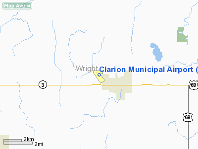
Clarion Municipal Airport (ICAO: KCAV, FAA LID: CAV) is a city-owned public-use airport located one nautical mile (1.85 km) northwest of the central business district of Clarion, a city in Wright County, Iowa, United States. This airport is included in the FAA's National Plan of Integrated Airport Systems for 2009–2013, which categorized it as a general aviation facility.
Although many U.S. airports use the same three-letter location identifier for the FAA and IATA, this facility is assigned CAV by the FAA but has no designation from the IATA (which assigned CAV to Cazombo Airport in Angola).
Facilities and aircraft
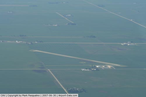
Clarion Municipal Airport covers an area of 255 acres (103 ha) at an elevation of 1,162 feet (354 m) above mean sea level. It has one runway designated 14/32 with a concrete surface measuring 3,515 by 60 feet (1,071 x 18 m).
For the 12-month period ending May 6, 2009, the airport had 3,750 general aviation aircraft operations, an average of 10 per day. At that time there were 12 aircraft based at this airport: 75% single-engine, 17% multi-engine and 8% ultralight.
The above content comes from Wikipedia and is published under free licenses – click here to read more.
|
 |
(Click on the photo to enlarge) |
Location
& QuickFacts
|
FAA Information Effective: |
2007-07-05 |
|
Airport
Identifier: |
CAV |
|
Airport
Status: |
Operational |
|
Longitude/Latitude: |
093-45-32.0740W/42-44-30.9980N
-93.758909/42.741944 (Estimated) |
|
Elevation: |
1162 ft / 354.18 m (Surveyed) |
|
Land: |
255 acres |
|
From
nearest city: |
1 nautical miles NW of Clarion, IA |
|
Location: |
Wright County, IA |
|
Magnetic Variation: |
04E (1985) |
Owner
& Manager
|
Ownership: |
Publicly owned |
|
Owner: |
City Of Clarion |
|
Address: |
121 1st St. Sw
Clarion, IA 50525 |
|
Phone number: |
515-851-0526 |
|
Manager: |
Jon Devries |
|
Address: |
2076 - 210th Street
Clarion, IA 50525 |
|
Phone number: |
515-532-6980 |
Airport
Operations and Facilities
|
Airport Use: |
Open to public |
|
Wind
indicator: |
Yes |
|
Segmented
Circle: |
No |
|
Control
Tower: |
No |
|
Lighting
Schedule: |
DUSK-DAWN
RY 14/32 MIRL PRESET LOW INTST; ACTVT VASI & REIL RY
14 & 32 & MIRL RY 14/32 HIGHER INTST - CTAF. |
|
Beacon
Color: |
Clear-Green (lighted land airport) |
|
Landing
fee charge: |
No |
|
Sectional
chart: |
Omaha |
|
Region: |
ACE - Central |
|
Boundary
ARTCC: |
ZMP - Minneapolis |
|
Tie-in
FSS: |
FOD - Fort Dodge |
|
FSS
on Airport: |
No |
|
FSS
Phone: |
515-955-8114 |
|
FSS
Toll Free: |
1-800-WX-BRIEF |
|
NOTAMs
Facility: |
CAV (NOTAM-d service avaliable) |
|
Federal Agreements: |
NY1 |
Airport
Communications
|
CTAF: |
122.800 |
|
Unicom: |
122.800 |
Airport
Services
|
Fuel available: |
100LL |
|
Bottled
Oxygen: |
NONE |
|
Bulk
Oxygen: |
NONE |
|
Runway Information
Runway 08/26
|
Dimension: |
1380 x 110 ft / 420.6 x 33.5 m |
|
Surface: |
TURF, Good Condition |
|
|
Runway 08 |
Runway 26 |
|
Longitude: |
093-45-43.7750W |
093-45-17.7730W |
|
Latitude: |
42-44-39.8980N |
42-44-39.8980N |
|
Alignment: |
90 |
127 |
|
Traffic
Pattern: |
Left |
Left |
|
Runway 14/32
|
Dimension: |
3515 x 60 ft / 1071.4 x 18.3 m |
|
Surface: |
CONC, Good Condition |
|
Weight
Limit: |
Single wheel: 17000 lbs. |
|
Edge
Lights: |
Medium |
|
|
Runway 14 |
Runway 32 |
|
Longitude: |
093-45-46.1340W |
093-45-19.5990W |
|
Latitude: |
42-44-40.2950N |
42-44-11.6100N |
|
Elevation: |
1152.00 ft |
1156.00 ft |
|
Alignment: |
127 |
127 |
|
Traffic
Pattern: |
Left |
Left |
|
Markings: |
Non-precision instrument, Fair Condition |
Non-precision instrument, Good Condition |
|
VASI: |
2-box on left side |
2-box on left side |
|
Runway
End Identifier: |
Yes |
Yes |
|
Obstruction: |
18 ft road, 485.0 ft from runway, 290 ft left
of centerline, 15:1 slope to clear |
77 ft tree, 2280.0 ft from runway, 27:1 slope
to clear |
|
Radio Navigation
Aids
|
ID |
Type |
Name |
Ch |
Freq |
Var |
Dist |
|
CAV |
NDB |
Clarion |
|
387.00 |
03E |
0.2 nm |
|
EAG |
NDB |
Eagle Grove |
|
302.00 |
03E |
7.0 nm |
|
EBS |
NDB |
Webster City |
|
323.00 |
03E |
18.7 nm |
|
HPT |
NDB |
Hampton |
|
230.00 |
03E |
23.6 nm |
|
IFA |
NDB |
Iowa Falls |
|
368.00 |
03E |
27.0 nm |
|
FXY |
NDB |
Forest City |
|
359.00 |
05E |
30.3 nm |
|
AXA |
NDB |
Algona |
|
403.00 |
03E |
30.5 nm |
|
POH |
NDB |
Pocahontas |
|
428.00 |
06E |
39.2 nm |
|
BNW |
NDB |
Boone |
|
407.00 |
03E |
41.5 nm |
|
EGQ |
NDB |
Emmetsburg |
|
410.00 |
04E |
47.0 nm |
|
FOD |
VORTAC |
Fort Dodge |
082X |
113.50 |
07E |
25.0 nm |
|
MCW |
VORTAC |
Mason City |
096X |
114.90 |
06E |
28.4 nm |
Based
Aircraft
|
Aircraft
based on field: |
8 |
|
Single
Engine Airplanes: |
5 |
|
Multi
Engine Airplanes: |
1 |
|
Ultralights: |
2 |
Operational Statistics
Time Period: 2005-09-12 - 2006-09-11
|
Aircraft
Operations: |
88/Week |
|
General
Aviation Local: |
40.0% |
|
General
Aviation Itinerant: |
60.0% |
Clarion Municipal Airport
Address:
Wright County, IA
Tel:
515-851-0526, 515-532-6980
Images
and information placed above are from
http://www.airport-data.com/airport/CAV/
We
thank them for the data!
| General
Info |
| Country |
United
States |
| State |
IOWA
|
| FAA ID |
CAV
|
| Latitude |
42-44-30.998N
|
| Longitude |
093-45-32.074W
|
| Elevation |
1162 feet
|
| Near City |
CLARION
|
We don't guarantee the information is fresh and accurate. The data may
be wrong or outdated.
For more up-to-date information please refer to other sources.
|
|


