 |
|
Cherokee County Regional Airport |
|
|
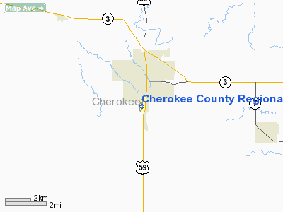
Location
& QuickFacts
|
FAA Information Effective: |
2007-07-05 |
|
Airport
Identifier: |
CKP |
|
Airport
Status: |
Operational |
|
Longitude/Latitude: |
095-33-21.4210W/42-43-54.0990N
-95.555950/42.731694 (Estimated) |
|
Elevation: |
1226 ft / 373.68 m (Surveyed) |
|
Land: |
155 acres |
|
From
nearest city: |
1 nautical miles S of Cherokee, IA |
|
Location: |
Cherokee County, IA |
|
Magnetic Variation: |
05E (1985) |
Owner
& Manager
|
Ownership: |
Publicly owned |
|
Owner: |
City Of Cherokee |
|
Address: |
1201 South 2nd Street
Cherokee, IA 51012 |
|
Phone
number: |
712-261-2011 |
|
Manager: |
Brian Lauck
KENT WENCH, CHMN ARPT AUTHORITY: 712-225-2810. |
|
Address: |
Muni Arpt 1201 S 2nd St
Cherokee, IA 51012 |
|
Phone number: |
712-225-2810 |
Airport
Operations and Facilities
|
Airport Use: |
Open to public |
|
Wind
indicator: |
Yes |
|
Segmented
Circle: |
No |
|
Control
Tower: |
No |
|
Lighting
Schedule: |
DUSK-DAWN
ACTVT MIRL RY 18/36; REIL & PAPI RYS 18 & 36 - CTAF. |
|
Beacon
Color: |
Clear-Green (lighted land airport) |
|
Landing
fee charge: |
No |
|
Sectional
chart: |
Omaha |
|
Region: |
ACE - Central |
|
Boundary
ARTCC: |
ZMP - Minneapolis |
|
Tie-in
FSS: |
FOD - Fort Dodge |
|
FSS
on Airport: |
No |
|
FSS
Phone: |
515-955-8114 |
|
FSS
Toll Free: |
1-800-WX-BRIEF |
|
NOTAMs
Facility: |
CKP (NOTAM-d service avaliable) |
|
Federal Agreements: |
NGY |
Airport
Communications
|
CTAF: |
122.800 |
|
Unicom: |
122.800 |
Airport
Services
|
Fuel available: |
100LLA
FOR FUEL AFT HRS CALL (712) 225-6168 OR (712) 229-9365. |
|
Airframe Repair: |
MAJOR
FOR MAJOR REPAIRS AFT HRS CALL (712) 225-4736. |
|
Power Plant Repair: |
MAJOR |
|
Runway Information
Runway 01/19
|
Dimension: |
2580 x 100 ft / 786.4 x 30.5 m |
|
Surface: |
TURF, Fair Condition |
|
|
Runway 01 |
Runway 19 |
|
Longitude: |
095-33-26.0620W |
095-33-21.0000W |
|
Latitude: |
42-43-50.6020N |
42-44-09.8000N |
|
Elevation: |
1213.00 ft |
1212.00 ft |
|
Alignment: |
11 |
127 |
|
Traffic
Pattern: |
Left |
Left |
|
Displaced
threshold: |
600.00 ft |
0.00 ft |
|
Obstruction: |
29 ft rr, 190.0 ft from runway, 6:1 slope to
clear
APCH SLOPE 27:1 APCH SLOPE TO DSPLCD THLD. |
54 ft trees, 1250.0 ft from runway, 50 ft left
of centerline, 23:1 slope to clear |
|
Runway 18/36
|
Dimension: |
4000 x 75 ft / 1219.2 x 22.9 m |
|
Surface: |
CONC, Good Condition |
|
Weight
Limit: |
Single wheel: 15000 lbs. |
|
Edge
Lights: |
Medium |
|
|
Runway 18 |
Runway 36 |
|
Longitude: |
095-33-19.1030W |
095-33-21.6500W |
|
Latitude: |
42-44-10.8140N |
42-43-31.3450N |
|
Elevation: |
1212.00 ft |
1226.00 ft |
|
Alignment: |
127 |
3 |
|
Traffic
Pattern: |
Left |
Left |
|
Markings: |
Non-precision instrument, Fair Condition |
Non-precision instrument, Fair Condition |
|
Crossing
Height: |
52.00 ft |
28.00 ft |
|
Displaced
threshold: |
200.00 ft |
0.00 ft |
|
VASI: |
2-light PAPI on left side |
2-light PAPI on right side |
|
Visual
Glide Angle: |
3.60° |
2.94° |
|
Runway
End Identifier: |
Yes |
Yes |
|
Obstruction: |
54 ft trees, 1150.0 ft from runway, 150 ft
left of centerline, 17:1 slope to clear |
90 ft ant, 2000.0 ft from runway, 260 ft right
of centerline, 20:1 slope to clear |
|
Radio Navigation
Aids
|
ID |
Type |
Name |
Ch |
Freq |
Var |
Dist |
|
CKP |
NDB |
Pilot Rock |
|
423.00 |
05E |
0.1 nm |
|
SLB |
NDB |
Storm Lake |
|
434.00 |
04E |
15.9 nm |
|
ORC |
NDB |
Orange City |
|
521.00 |
05E |
27.2 nm |
|
LTU |
NDB |
Little Sioux |
|
326.00 |
05E |
30.2 nm |
|
SHL |
NDB |
Sheldon |
|
338.00 |
05E |
31.5 nm |
|
SKI |
NDB |
Sac City |
|
356.00 |
04E |
33.0 nm |
|
MEY |
NDB |
Mapleton |
|
335.00 |
05E |
34.8 nm |
|
SOY |
NDB |
Sioux Center |
|
368.00 |
06E |
36.9 nm |
|
ISB |
NDB |
Sibley |
|
269.00 |
05E |
39.2 nm |
|
POH |
NDB |
Pocahontas |
|
428.00 |
06E |
40.1 nm |
|
SU |
NDB |
Salix |
|
414.00 |
07E |
40.6 nm |
|
GAK |
NDB |
Sioux Gateway |
|
233.00 |
06E |
41.6 nm |
|
OI |
NDB |
Tommi |
|
305.00 |
07E |
43.3 nm |
|
EGQ |
NDB |
Emmetsburg |
|
410.00 |
04E |
43.5 nm |
|
DNS |
NDB |
Denison |
|
350.00 |
04E |
45.6 nm |
|
SPW |
VOR/DME |
Spencer |
037X |
110.00 |
05E |
30.2 nm |
|
DDL |
VOR/DME |
Sheldon |
023X |
108.60 |
05E |
31.4 nm |
|
SUX |
VORTAC |
Sioux City |
112X |
116.50 |
09E |
41.2 nm |
Remarks
- WATERFOWL
ON & INVOF ARPT.
Based
Aircraft
|
Aircraft
based on field: |
42 |
|
Single
Engine Airplanes: |
37 |
|
Multi
Engine Airplanes: |
4 |
|
Ultralights: |
1 |
Operational Statistics
Time Period: 2004-11-22 - 2005-11-21
|
Aircraft
Operations: |
91/Week |
|
General
Aviation Local: |
42.3% |
|
General
Aviation Itinerant: |
57.7% |
Cherokee County Regional Airport
Address:
Cherokee County, IA
Tel:
712-261-2011,
712-225-2810
Images
and information placed above are from
http://www.airport-data.com/airport/CKP/
We
thank them for the data!
| General
Info |
| Country |
United
States |
| State |
IOWA
|
| FAA ID |
CKP
|
| Latitude |
42-43-53.300N
|
| Longitude |
095-33-22.100W
|
| Elevation |
1219 feet
|
| Near City |
CHEROKEE
|
We don't guarantee the information is fresh and accurate. The data may
be wrong or outdated.
For more up-to-date information please refer to other sources.
|
|


