 |
|
Chariton Municipal Airport |
|
|
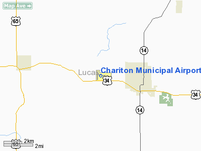
Location
& QuickFacts
|
FAA Information Effective: |
2007-07-05 |
|
Airport
Identifier: |
CNC |
|
Airport
Status: |
Operational |
|
Longitude/Latitude: |
093-21-34.8490W/41-01-10.6460N
-93.359680/41.019624 (Estimated) |
|
Elevation: |
1050 ft / 320.04 m (Surveyed) |
|
Land: |
120 acres |
|
From
nearest city: |
3 nautical miles W of Chariton, IA |
|
Location: |
Lucas County, IA |
|
Magnetic Variation: |
03E (1995) |
Owner
& Manager
|
Ownership: |
Publicly owned |
|
Owner: |
City Of Chariton |
|
Address: |
115 South Main
Chariton, IA 50049 |
|
Phone number: |
641-774-5991 |
|
Manager: |
Nels Christensen |
|
Address: |
Route 5
Chariton, IA 50049 |
|
Phone number: |
641-774-2599 |
Airport
Operations and Facilities
|
Airport Use: |
Open to public |
|
Wind
indicator: |
Yes |
|
Segmented
Circle: |
Yes |
|
Control
Tower: |
No |
|
Lighting
Schedule: |
DUSK-DAWN
MIRL RYS 17/35 & 10/28 PRESET ON LOW INTST; TO INCR
INTST AND ACTVT REIL RYS 17/35 & 10/28 - CTAF.
PAPI
RYS 17 & 35 ACTVT - CTAF. |
|
Beacon
Color: |
Clear-Green (lighted land airport) |
|
Landing
fee charge: |
No |
|
Sectional
chart: |
Omaha |
|
Region: |
ACE - Central |
|
Boundary
ARTCC: |
ZAU - Chicago |
|
Responsible
ARTCC: |
ZMP - Minneapolis |
|
Tie-in
FSS: |
FOD - Fort Dodge |
|
FSS
on Airport: |
No |
|
FSS
Phone: |
515-955-8114 |
|
FSS
Toll Free: |
1-800-WX-BRIEF |
|
NOTAMs
Facility: |
CNC (NOTAM-d service avaliable) |
|
Federal Agreements: |
NY1 |
Airport
Communications
|
CTAF: |
122.800 |
|
Unicom: |
122.800 |
Airport
Services
|
Fuel available: |
100LLA |
|
Airframe Repair: |
NONE |
|
Power Plant Repair: |
NONE |
|
Bottled
Oxygen: |
NONE |
|
Bulk
Oxygen: |
NONE |
|
Runway Information
Runway 10/28
|
Dimension: |
4000 x 75 ft / 1219.2 x 22.9 m |
|
Surface: |
CONC, Good Condition |
|
Surface
Treatment: |
Wire Comb or Wire Tine |
|
Edge
Lights: |
Medium |
|
|
Runway 10 |
Runway 28 |
|
Longitude: |
093-21-48.4780W |
093-20-57.3830W |
|
Latitude: |
41-01-14.7680N |
41-01-06.7440N |
|
Elevation: |
1046.00 ft |
1034.00 ft |
|
Alignment: |
102 |
127 |
|
Traffic
Pattern: |
Left |
Left |
|
Markings: |
Non-precision instrument, Fair Condition |
Non-precision instrument, Fair Condition |
|
Crossing
Height: |
26.00 ft |
30.00 ft |
|
VASI: |
2-box on left side |
2-box on left side |
|
Visual
Glide Angle: |
3.00° |
3.00° |
|
Runway
End Identifier: |
Yes |
Yes |
|
Obstruction: |
25 ft trees, 775.0 ft from runway, 150 ft left
of centerline, 23:1 slope to clear
+18' ROAD AT 650' GLIDESLOPE 25:1. |
32 ft trees, 765.0 ft from runway, 133 ft left
of centerline, 17:1 slope to clear |
|
Runway 17/35
|
Dimension: |
2800 x 75 ft / 853.4 x 22.9 m |
|
Surface: |
CONC, Good Condition |
|
Weight
Limit: |
Single wheel: 4000 lbs. |
|
Edge
Lights: |
Medium |
|
|
Runway 17 |
Runway 35 |
|
Longitude: |
093-21-51.8550W |
093-21-51.8970W |
|
Latitude: |
41-01-24.3200N |
41-00-56.6530N |
|
Elevation: |
1038.00 ft |
1050.00 ft |
|
Alignment: |
127 |
0 |
|
Traffic
Pattern: |
Left |
Left |
|
Markings: |
Non-precision instrument, Fair Condition |
Non-precision instrument, Fair Condition |
|
VASI: |
2-light PAPI on left side |
2-light PAPI on left side |
|
Runway
End Identifier: |
Yes |
Yes |
|
Obstruction: |
, 50:1 slope to clear |
15 ft road, 500.0 ft from runway, 20:1 slope
to clear |
|
Radio Navigation
Aids
|
ID |
Type |
Name |
Ch |
Freq |
Var |
Dist |
|
CNC |
NDB |
Chariton |
|
335.00 |
05E |
0.2 nm |
|
OXV |
NDB |
Knoxville |
|
284.00 |
03E |
20.0 nm |
|
TVK |
NDB |
Centerville |
|
290.00 |
04E |
28.9 nm |
|
PEA |
NDB |
Pella |
|
257.00 |
02E |
29.9 nm |
|
OOA |
NDB |
Oskaloosa |
|
414.00 |
03E |
41.4 nm |
|
IKV |
NDB |
Ankeny |
|
275.00 |
03E |
41.8 nm |
|
UNE |
NDB |
Union County |
|
379.00 |
04E |
45.0 nm |
|
BEX |
NDB |
Bloomfield |
|
269.00 |
02E |
45.3 nm |
|
OTM |
VOR/DME |
Ottumwa |
053X |
111.60 |
06E |
46.9 nm |
|
TNU |
VOR/DME |
Newton |
072X |
112.50 |
03E |
47.3 nm |
|
DSM |
VORTAC |
Des Moines |
122X |
117.50 |
07E |
28.3 nm |
|
LMN |
VORTAC |
Lamoni |
114X |
116.70 |
07E |
37.6 nm |
|
DSM |
VOT |
Des Moines |
|
109.20 |
|
34.3 nm |
Based
Aircraft
|
Aircraft
based on field: |
20 |
|
Single
Engine Airplanes: |
18 |
|
Multi
Engine Airplanes: |
2 |
Operational Statistics
Time Period: 2003-07-17 - 2004-07-15
|
Aircraft
Operations: |
37/Week |
|
General
Aviation Local: |
53.0% |
|
General
Aviation Itinerant: |
47.0% |
Chariton Municipal Airport
Address:
Lucas County, IA
Tel:
641-774-5991, 641-774-2599
Images
and information placed above are from
http://www.airport-data.com/airport/CNC/
We
thank them for the data!
| General
Info |
| Country |
United
States |
| State |
IOWA
|
| FAA ID |
CNC
|
| Latitude |
41-01-10.646N
|
| Longitude |
093-21-34.849W
|
| Elevation |
1050 feet
|
| Near City |
CHARITON
|
We don't guarantee the information is fresh and accurate. The data may
be wrong or outdated.
For more up-to-date information please refer to other sources.
|
|


